
Kensington is an unincorporated community and census designated place located in the Berkeley Hills, in the East Bay, part of the San Francisco Bay Area, in Contra Costa County, California. The population was 5,077 at the 2010 census.
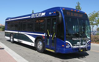
WestCAT is a public transportation service in western Contra Costa County. It is a service of the Western Contra Costa Transit Authority.

State Route 123 is a state highway in the U.S. state of California in the San Francisco Bay Area. Named San Pablo Avenue for virtually its entire length, SR 123 is a major north–south state highway along the flats of the urban East Bay in the U.S. state of California. Route 123 runs a relatively short 7.39 miles (11.9 km) between Interstate 580 in the south and Interstate 80 in the north. San Pablo Avenue itself, a portion of Historic US 40, continues well past these termini but without the Route 123 designation.
The West Contra Costa Unified School District is the school district for western Contra Costa County, California. It is based in Richmond, California. In addition to Richmond, the district covers the cities of El Cerrito, San Pablo, Pinole, and Hercules and the unincorporated areas of Bayview-Montalvin Manor, East Richmond Heights, El Sobrante, Kensington, North Richmond, and Tara Hills.

The East Bay Times is a daily broadsheet newspaper based in Walnut Creek, California, United States owned by the Bay Area News Group (BANG), as subsidiary of Digital First Media, that serves Contra Costa and Alameda counties, in the eastern part of the San Francisco Bay Area. It was founded as the Contra Costa Times, and took its current name in 2016 when it was merged with other sister papers in the East Bay region.
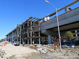
El Cerrito del Norte is a BART station located off Cutting Boulevard near San Pablo Avenue and Interstate 80 in El Cerrito, California. The station serves as a regional transit hub for local AC Transit bus services, and for commuter feeder services from Solano, Napa, and Marin Counties in the North Bay plus western Contra Costa County. Opened in 1973, the station is undergoing a renovation expected to be completed in 2019.
KCRT-TV is a local cable news cable TV station in Richmond, California. It mostly plays historic archives and historic documentary, news, as well as the long-running Sidewalks Entertainment. In Richmond, the station appears on Channel 28.
Richmond Annex or The Annex is a neighborhood in southeastern Richmond, California. It is mostly residential and located between San Pablo Avenue/El Cerrito to the east, San Francisco Bay to the west, Central Avenue/Cerrito Creek/Albany Hill/Albany/Alameda County to the south, and Potrero Avenue/Pullman to the north. Carlson Boulevard is the main thoroughfare through the annex, connecting downtown Richmond with downtown El Cerrito.

Cutting Boulevard is a major east-west arterial trunk road in the city of Richmond, California.
Cerrito, Cerritos, El Cerrito, or Los Cerritos may refer to:

Cerrito Creek is one of the principal watercourses running out of the Berkeley Hills into San Francisco Bay in northern California. It is significant for its use as a boundary demarcation historically, as well as presently. In the early 19th century, it separated the vast Rancho San Antonio to the south from the Castro family's Rancho San Pablo to the north. Today, it marks part of the boundary between Alameda County and Contra Costa County. The main stem, running through a deep canyon that separates Berkeley from Kensington, is joined below San Pablo Avenue by a fan of tributaries, their lower reaches mostly in culverts. The largest of these is Middle or Blackberry Creek, a southern branch.
Fluvius Innominatus or Central Creek is a creek in Richmond and El Cerrito, California in western Contra Costa County. There is one main source and a secondary unnamed tributary. The creek drains into Hoffman Marsh and then flows into the bay through Point Isabel Regional Shoreline's Hoffman Channel. However, before the area was developed and as early as 1899 the creek had 11 sources which stretched far higher into the Berkeley Hills.
Víctor Ramón Castro was a landowner in an area of Alta California which later became part of Contra Costa County, California. Víctor Castro was the son of Francisco María Castro, a former soldier at the San Francisco Presidio, one-time alcalde of the Pueblo of San José, and grantee of Rancho San Pablo.

The Eastshore and Suburban Railway (E&SR) was a formerly independent unit of the historic San Francisco Bay Area Key System which ran streetcar trains in Richmond, California, San Pablo, and El Cerrito. There were several lines with terminals at Point Richmond, North Richmond, the county line with Alameda County, what is now San Pablo, and Grand Canyon/East Richmond/Alvarado Park. Service to Oakland required a transfer to Oakland Traction Company trains at the County Line station and service to San Francisco required an additional transfer in Oakland. The systems were later consolidated into the Key System. Service began to be replaced by buses beginning on August 1, 1932, with the conversion of the East Richmond/23rd Street line to buses. Lines were converted to buses one at a time with the last remaining line being in September 1933. Fares were originally 5 cents and were raised to 7 cents over time at the time of the last runs.

Hercules Transit Center is a major commuter hub in the western Contra Costa County city of
Hercules, California. It is anchored by WestCAT bus services. The center was originally on San Pablo Avenue. In August 2009, the transit center was relocated to the other side of I-80 with additional paid parking.

Stege, founded in 1876, was an unincorporated community in western Contra Costa County, California, United States. The town has now been annexed and absorbed by the cities of Richmond and El Cerrito, California. It was located on the Southern Pacific Railroad 1.5 miles (2.4 km) south-southeast of downtown Richmond, at an elevation of 23 feet. The site is now located in the area known as the Richmond Annex, at coordinates: 37°55′00″N 122°19′38″W.
The Contra Costa County Board of Supervisors is the governing body for Contra Costa County, California in the San Francisco Bay Area's East Bay region. Members of the Board of supervisors are elected from districts, based on their residence.

John Gioia is an American politician. He has served on the Contra Costa County Board of Supervisors in Contra Costa County, California since 1998 and was re-elected three times. He served as chair in 2002, 2006 and 2010. John Gioia is a Democrat. Contra Costa Supervisory seats are non-partisan.

GoLibrary or Library-a-Go-Go is a book lending vending machine used by libraries in Sweden and the U.S. state of California. The Contra Costa Library was the body that first brought these machines to the United States.


