
County Cork is the largest and the southernmost county of Ireland, named after the city of Cork, the state's second-largest city. It is in the province of Munster and the Southern Region. Its largest market towns are Mallow, Macroom, Midleton, and Skibbereen. As of 2022 the county had a population of 581,231, making it the third-most populous county in Ireland. Cork County Council is the local authority for the county, while Cork City Council governs the city of Cork and its environs. Notable Corkonians include Michael Collins, Jack Lynch, Roy Keane, Sonia O'Sullivan and Cillian Murphy.
County Kilkenny is a county in Ireland. It is in the province of Leinster and is part of the South-East Region. It is named after the city of Kilkenny. Kilkenny County Council is the local authority for the county. As of the 2022 census the population of the county was just over 100,000. The county was based on the historic Gaelic kingdom of Ossory (Osraighe), which was coterminous with the Diocese of Ossory.

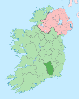
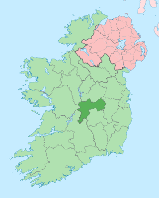
County Tipperary is a county in Ireland. It is in the province of Munster and the Southern Region. The county is named after the town of Tipperary, and was established in the early 13th century, shortly after the Norman invasion of Ireland. It is Ireland's largest inland county and shares a border with eight counties, more than any other. The population of the county was 159,553 at the 2016 census. The largest towns are Clonmel, Nenagh and Thurles.
County Offaly is a county in Ireland. It is part of the Eastern and Midland Region and the province of Leinster. It is named after the ancient Kingdom of Uí Failghe. It was formerly known as King's County, in honour of Philip II of Spain. Offaly County Council is the local authority for the county. The county population was 82,668 at the 2022 census.
Blanchardstown is a large outer suburb of Dublin in the modern county of Fingal, Ireland. Located ten kilometres (6 mi) northwest of Dublin city centre, it has developed since the 1960s from a small village to a point where Greater Blanchardstown is the largest urban area in Fingal.

Athea is a village in west County Limerick, Ireland. Athea has a Roman Catholic church, and is the centre for the parish of Athea, which encompasses several nearby townlands.

Williamstown is a small village located on the R360 regional road in the townland of Corralough in northeast County Galway, Ireland. According to the census in April 2016, the population of the village was 148.

Naul, is a village, townland, and civil parish at the northern edge of Fingal and the traditional County Dublin in Ireland. The Delvin River to the north of the village marks the county boundary with County Meath. Naul civil parish is in the historic barony of Balrothery West.

Ballyhale is a village in the south east of Ireland. Located in the south of County Kilkenny, south of the city of Kilkenny and roughly halfway to Waterford city.
Roxborough is a townland in County Limerick, Ireland comprising some 24.02 km2. It lies to the south of the townlands of Ballysheedy and Routagh and to the east of the townland of Ballyclough. Its northern boundary, partially bounded by the Ballyclough River, lies some three kilometres to the south of the Limerick City boundary at Southill. The Limerick to Fedamore road (R511) bounds the west side of Roxborough.
Balally, County Dublin, Ireland, is a townland and residential area between Dundrum village and the Sandyford Industrial Estate in Sandyford.

Kilsheelan is a village and civil parish within the in the barony of Iffa and Offa East in County Tipperary, Ireland. It is also one half of the Roman Catholic parish of Kilsheelan & Kilcash in the Roman Catholic Diocese of Waterford and Lismore.
Ballyhide is a rural townland and village in the extreme south eastern corner of County Laois, Ireland at the border with County Carlow. The nearest urban centre is Carlow town which is 3 kilometres to the north east. It is located in the Luggacurren Local Electoral District.
Arywee is a townland in the parish of Fedamore, in County Limerick, Ireland.

Carnane is a townland in the parish of Fedamore, in County Limerick, Ireland.
Fanningstown is a townland in the parish of Fedamore, in County Limerick, Ireland.

Ballingarry is a civil parish and a townland in the barony of Ormond Lower, County Tipperary in Ireland. It is located on the N52 between Borrisokane and Birr. Ballingarry townland has an area of 5.3 square kilometres (2 sq mi), and had a population of 170 people as of the 2011 census.
Fedamore is a small village in County Limerick, Ireland. As of the 2016 census, Fedamore had a population of 329 people. It is also a civil parish in the ancient barony of Smallcounty.
Smallcounty or ‘’’Small County’’’ is a historical barony in County Limerick, Ireland. Settlements in the barony include Hospital, Herbertstown, Fedamore, Knockainy, and Six-Mile-Bridge.
Ballyhahill is a village and townland in County Limerick, Ireland. As of the 2016 census, the village had a population of 146 people. The White River flows to the east of the village.

