Shenandoah Mountain is a mountain ridge approximately 73 miles (117 km) long in Virginia and West Virginia. The steep, narrow, sandstone-capped ridge extends from northern Bath County, Virginia to southern Hardy County, West Virginia. Along the way, its crest defines the borders between Highland and Augusta counties, Virginia, and between Pendleton County, West Virginia, and Rockingham County, Virginia. The name comes from the Iroquoian word for 'deer'.
The Willis River is a 61.8-mile-long (99.5 km) tributary of the James River in central Virginia in the United States. Via the James River, it is part of the watershed of Chesapeake Bay.

Glendale National Cemetery is a United States National Cemetery located near the city of Richmond, in Henrico County, Virginia. Administered by the United States Department of Veterans Affairs, it encompasses 2.1 acres (0.85 ha), and as of the end of 2005 had 2,064 interments. It is closed to new interments.

Fayette is an unincorporated community in Fayette County, West Virginia, United States. Its elevation is 919 feet (280 m). It is the major take-out for the lower section of the New River Gorge National River.

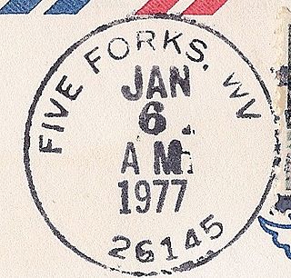
Five Forks is an unincorporated community in Calhoun County, West Virginia, United States. It lies along West Virginia Route 16 to the north of the town of Grantsville, the county seat of Calhoun County. Its elevation is 1,106 feet (337 m). The Five Forks Post Office is closed.

Hix is an unincorporated community in Summers County, West Virginia, United States. It lies to the northeast of the city of Hinton, the county seat of Summers County. Its elevation is 2,618 feet. At some point, Hix possessed a post office, which closed on December 6, 1975.

Smoot is an unincorporated community in western Greenbrier County, West Virginia, United States. It lies south of the interchange of Interstate 64 and U.S. Route 60 northwest of the city of Lewisburg, the county seat of Greenbrier County. Its elevation is 2,480 feet (756 m). Although it is unincorporated, it has a post office, with the ZIP code of 24977.

Rock Castle is an unincorporated community in southwestern Jackson County, West Virginia, United States. It lies along Rock Castle Road south of the city of Ripley, the county seat of Jackson County. Its elevation is 705 feet (215 m).

Murraysville is an unincorporated community in northern Jackson County, West Virginia, United States, along the Ohio River across from Long Bottom, Ohio. It lies along Murraysville Road north of the city of Ripley, the county seat of Jackson County. Its elevation is 591 feet (180 m).

Kentuck is an unincorporated community in southeastern Jackson County, West Virginia, United States. It lies along Kentuck Road southeast of the city of Ripley, the county seat of Jackson County. Its elevation is 922 feet (281 m).

Flatwoods is an unincorporated community in northwestern Jackson County, West Virginia, United States. It lies at the intersection of Crooked Run and Harpold Roads, northwest of the city of Ripley, the county seat of Jackson County. Its elevation is 755 feet (230 m).

Belva is an unincorporated community and census-designated place in west Nicholas County and north Fayette County, West Virginia, United States; while the CDP only includes the Nicholas County portion, the Fayette County portion is considered part of the community. The town is situated at the bottomland surrounding the convergence of Bells Creek with Twentymile Creek and, subsequently, Twenty Mile Creek with the Gauley River. Belva is also the location of the convergence of two state highways: West Virginia Route 16 and West Virginia Route 39.

Willis is an unincorporated community in southwestern Floyd County, Virginia, United States. It lies along U.S. Route 221 southwest of the town of Floyd, the county seat of Floyd County. It has an elevation of 2,723 feet (830 m). Although Willis is unincorporated, it has a post office, with the ZIP code of 24380.

Robley is an unincorporated community in southeastern Richmond County, Virginia, United States. It lies along State Route 3 southeast of the town of Warsaw, the county seat of Richmond County. Its elevation is 115 feet (35 m).

Pool is an unincorporated community in southwestern Nicholas County, West Virginia, United States. It lies along CR 41-7 just east of Route 41, south of the town of Summersville, the county seat of Nicholas County. Its elevation is 2,142 feet (653 m). Although Pool is unincorporated, it has a ZIP code of 26684; it once had its own post office, which opened on March 31, 1881, and closed on March 19, 2011. The community took its name from standing pool of water near the original town site.

Neola is an unincorporated community in northeastern Greenbrier County, West Virginia, United States. It lies along West Virginia Route 92 north of the city of White Sulphur Springs. Its elevation is 2,037 feet (621 m).
Willis Mountain is a monadnock rising from the rolling Piedmont hills of Buckingham County, Virginia, near the geographic center of the state. It is composed of Kyanite-bearing quartz that weathers more slowly than the surrounding material. The Kyanite Mining Corporation of Dillwyn has mined Willis Mountain long enough to reduce significantly the profile of the mountain.
Curdsville is an unincorporated community in Buckingham County, in the U.S. state of Virginia.

Willis Branch is an unincorporated community and coal town in Fayette County, West Virginia. It was also known as Herberton.

Ward is an unincorporated community and coal town in Kanawha County, West Virginia, United States. Its post office is closed. Ward is approximately 3 miles (4.8 km) northeast of Cedar Grove, along Kellys Creek.


