
The Willochra Plain is a wide plain situated east of Port Augusta, South Australia. The area falls in the view from Mount Brown Lookout and from walking trails in The Dutchmans Stern Conservation Park. [1]
The Willochra Plain is a wide plain situated east of Port Augusta, South Australia. The area falls in the view from Mount Brown Lookout and from walking trails in The Dutchmans Stern Conservation Park. [1]
The traditional owners of the area are the Ngadjuri people. [2] The first European explorer to sight the plain was Thomas Burr in September 1842. Burr was traversing the coastal plain between present Port Augusta and Port Pirie, on the western side of the rugged Southern Flinders Ranges, when he decided to leave the coast to cross eastward over the ranges. From the eastern escarpment he found that the ranges overlooked extensive "well-wooded and watered country", now called the Willochra Plain, stretching from what is now Melrose northward toward Quorn. [3] Burr's encouraging reports of his discoveries in this region immediately led to the arrival of European pastoralists.
The Ragless brothers were the first settlers on the plain later in the 1840s; they established a sheep station. The townsite of Willochra was surveyed in 1860 and the brothers established a hotel but the townsite was never further developed and was abandoned during the drought in the 1860s. [4] Overgrazing and the drought lead to the saltbush cover of the land being stripped and the area became a dustbowl. The Ragless brothers survived the drought but later lost the property when it was carved up into paddocks to grow wheat. [4]
The plain is bisected by a large but ephemeral gum-studded creek, named Willochra Creek. Willochra is an Aboriginal word meaning "a flooded creek, where green bushes grow". [5] Much of the plain lies north (outside) of Goyder's Line, which since 1865 has delineated the limits of South Australian lands suitable for agricultural settlement because of being semi-arid and drought-affected. Nevertheless, successive governments of the 1870s and 1880s surveyed and released former pastoral land for crop farming. Despite that being done on a generous credit selection basis, many settlers failed to be commercially viable due to the aridity.
As part of that process, many government townships were surveyed to service those settlers. They include Booleroo, Willowie, Hammond, Quorn and Wilmington. Some of these townships have thrived, some have merely survived, while others are practically deserted.

The Heysen Trail is a long distance walking trail in South Australia. It runs from Parachilna Gorge, in the Flinders Ranges via the Adelaide Hills to Cape Jervis on the Fleurieu Peninsula and is approximately 1,200 kilometres (750 mi) in length.
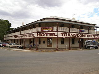
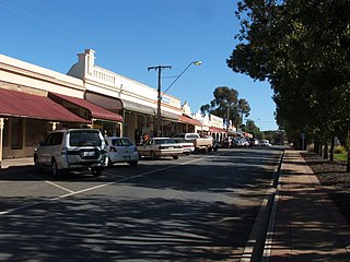
Quorn is a small town and railhead in the Flinders Ranges in the north of South Australia, 39 kilometres (24 mi) northeast of Port Augusta.

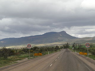
The Flinders Ranges are the largest mountain ranges in South Australia, which starts about 200 km (125 mi) north of Adelaide. The ranges stretch for over 430 km (265 mi) from Port Pirie to Lake Callabonna.

The Flinders Ranges Council is a local government area (LGA) located in the Flinders Ranges of South Australia.

The Mid North is a region of South Australia, north of the Adelaide Plains and south of the Far North and the outback. It is generally accepted to extend from Spencer Gulf east to the Barrier Highway, including the coastal plain, the southern part of the Flinders Ranges, and the northern part of the Mount Lofty Ranges. The Temperate Grassland of South Australia cover most of the area.
Edward John Eyre made two expeditions into the interior of South Australia in 1839. At the time nobody had been any further than the head of Spencer Gulf. The first expedition, in May, set out from Adelaide. It is not exactly clear how far north he reached before turning back, but somewhere in the Flinders Ranges. The second expedition, in August, sailed to Port Lincoln, and struck out west following the coast to Streaky Bay. Forced back again by inhospitable conditions, he went east and then further north than the previous attempt, eventually finding the lake that is now called Lake Torrens.
The Ngadjuri people are a group of Aboriginal Australian people whose traditional lands lie in the mid north of South Australia with a territory extending from Gawler in the south to Orroroo in the Flinders Ranges in the north.
Orroroo is a town in the Yorke and Mid North region of South Australia. At the 2016 census, the locality of Orroroo had a population of 610 while its urban centre had a population of 537. The Wilmington-Ucolta Road passes through here, intersecting with the RM Williams Way which leads to the Birdsville and Oodnadatta Tracks. The Peterborough–Quorn railway line extended from Peterborough to Orroroo also in 1881 and Quorn in 1882, connecting with the new Central Australia Railway from Port Augusta. These railways have now been abandoned. Orroroo is situated near Goyder's Line, a line drawn up in 1865 by Surveyor General Goyder which he believed indicated the edge of the area suitable for agriculture.

Kanyaka Station was a cattle and sheep station in the Flinders Ranges of South Australia located at Kanyaka, approximately 40 km (25 mi) north-north-east of Quorn, South Australia. along Hawker-Stirling North Road (B83).
Willochra is a rural locality and former town in the Flinders Ranges of South Australia, surveyed in 1860. It is at the heart of Willochra Plain which stretches approximately from Melrose to the Willochra locality, some distance northeast of Quorn, and is bisected by the Willochra Creek. The creek overflows across the plain within the locality of Willochra, being known as the 'Overflow of Willochra Creek'.
Thomas Burr (1813–1866), surveyor and mine manager, was a British explorer and Deputy Surveyor General of South Australia 1839–46.
The Dutchmans Stern is a mountain in South Australia located in the Flinders Ranges about 5 kilometres north-west of the town of Quorn and 25 kilometres north east of the city of Port Augusta.

The Dutchmans Stern Conservation Park is a protected area located in South Australia about 5 kilometres north-west of the town of Quorn in the Flinders Ranges. It includes a mountain known as The Dutchmans Stern from which its name is derived.

Kanyaka is a rural locality in the Far North region of South Australia, situated in the Flinders Ranges Council.
The Hundred of Boolcunda is a cadastral hundred of the County of Newcastle in South Australia. It was proclaimed by Governor Anthony Musgrave in 1876.
The County of Newcastle is one of the 49 counties of South Australia spanning the central Flinders Ranges. It was named in 1876 for Francis Pelham-Clinton-Hope, the eighth Duke of Newcastle.
The Hundred of Cudlamudla is a cadastral hundred of the County of Newcastle in South Australia, that is located at 32.195°S 138.215°E in the Flinders Ranges. The traditional owners of the area are the Ngadjuri people. The first European explorer to the area was Thomas Burr in September 1842. The hundred now combines with the adjacent Hundred of Kanyaka to constitute the locality of Kanyaka.

The Hundred of Pichi Richi is a cadastral hundred of the County of Newcastle in South Australia, and 293 m (961 ft) above sea level. It spans the eastern slopes of Dutchman Range and is centred on the township of Quorn.

The Hundred of Palmer is a cadastral hundred of the County of Newcastle in South Australia. It is located near 32.35°S, 138.21°E east of the township of Quorn, and south of the former town of Willochra which, although surveyed in 1860, never properly developed and was abandoned during the drought in the 1860s.

The County of Frome is one of the 49 cadastral counties of South Australia in straddling the Mid North and Flinders Ranges regions. It was proclaimed in 1851 by Governor Henry Young and was named for the former Surveyor-General of South Australia, Edward Charles Frome. The iconic Mount Remarkable in the Hundred of Gregory is at the centre of the county.