
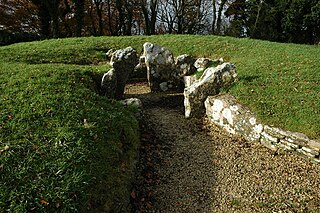
Maeshowe is a Neolithic chambered cairn and passage grave situated on Mainland Orkney, Scotland. It was probably built around 2800 BC. In the archaeology of Scotland, it gives its name to the Maeshowe type of chambered cairn, which is limited to Orkney.
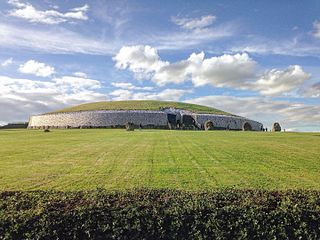
Newgrange is a prehistoric monument in County Meath, Ireland, located 8 kilometres (5.0 mi) west of Drogheda on the north side of the River Boyne. It is an exceptionally grand passage tomb built during the Neolithic period, around 3200 BC, making it older than Stonehenge and the Egyptian pyramids.

A bowl barrow is a type of burial mound or tumulus. A barrow is a mound of earth used to cover a tomb. The bowl barrow gets its name from its resemblance to an upturned bowl. Related terms include cairn circle, cairn ring, howe, kerb cairn, tump and rotunda grave.

Knowth is a Neolithic passage grave and an ancient monument of the World Heritage Site of Brú na Bóinne located 8.4 km west of Drogheda in Ireland's valley of the River Boyne. It is the largest passage grave of the Brú na Bóinne complex. It consists of a large mound and 17 smaller satellite tombs. The mound is about 12 metres (40 ft) high and 67 metres (220 ft) in diameter, covering roughly a hectare. It contains two passages placed along an east-west line and is encircled by 127 kerbstones, of which three are missing, and four badly damaged.

Rodmarton Manor is a large country house, in Rodmarton, near Cirencester, Gloucestershire, built for the Biddulph family. It is a Grade I listed building. It was constructed in the early 20th century in an Arts and Crafts style, to a design by Ernest Barnsley. After Ernest's death in 1925, it was completed by Sidney Barnsley, his brother, and then by Norman Jewson, Ernest's son-in-law. All the construction materials were obtained locally, and hand worked by local craftsmen.
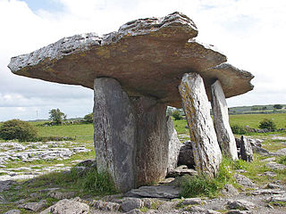
Poulnabrone dolmen is an unusually large dolmen or portal tomb located in the Burren, County Clare, Ireland. Situated on one of the most desolate and highest points of the region, it comprises three standing portal stones supporting a heavy horizontal capstone, and dates to the Neolithic period, probably between 4200 BC and 2900 BC. It is the best known and most widely photographed of the approximately 172 dolmens in Ireland.

Belas Knap is a neolithic, chambered long barrow situated on Cleeve Hill, near Cheltenham and Winchcombe, in Gloucestershire, England. It is a scheduled ancient monument in the care of English Heritage but managed by Gloucestershire County Council. "Belas" is possibly derived from the Latin word bellus, 'beautiful', which could describe the hill or its view. "Knap" is derived from the Old English for the top, crest, or summit of a hill.
Mine Howe is an Iron Age subterranean man-made chamber dug 6 meters deep inside a large mound. It is located in the Tankerness area of Orkney, Scotland, about 5 miles (8 km) southeast of Kirkwall, the capital of Orkney. The origin of the howe is not perfectly understood. Experts believe that it was built roughly 2000 years ago during the Iron Age. There is some similarity to the well inside the Iron Age Broch of Gurness.

The Stoney Littleton Long Barrow is a Neolithic chambered tomb with multiple burial chambers, located near the village of Wellow in the English county of Somerset. It is an example of the Cotswold-Severn Group and was scheduled as an ancient monument in 1882. It was one of the initial monuments included when the Ancient Monuments Protection Act 1882 became law.

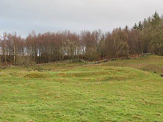
Pikestones is the remains of a Neolithic Burial Cairn, located on Anglezarke moor in Lancashire, England. The site is approximately 150 feet long and 60 feet across at its widest point. It consisted of one burial chamber constructed of large upright slabs, capped by two lintel slabs, forming a chamber of 15 feet long, 3 feet wide and 3 feet high, covered by a huge mound of stones and turves. The cairn was aligned almost exactly North-South, with the burial chamber under the wider northern end. At the northern edge of the cairn, a double wall could be made out, curving inwards to form an entrance to a forecourt.

Prehistoric Orkney refers only to the prehistory of the Orkney archipelago of Scotland that begins with human occupation. Although some records referring to Orkney survive that were written during the Roman invasions of Scotland, “prehistory” in northern Scotland is defined as lasting until the start of Scotland’s Early Historic Period.

Parc Cwm long cairn, also known as Parc le Breos burial chamber, is a partly restored Neolithic chambered tomb, identified in 1937 as a Severn-Cotswold type of chambered long barrow. The cromlech, a megalithic burial chamber, was built around 5850 years before present (BP), during the early Neolithic. It is about seven 1⁄2 miles (12 km) west south–west of Swansea, Wales, in what is now known as Coed y Parc Cwm at Parc le Breos, on the Gower Peninsula.

Midhowe Chambered Cairn is a large Neolithic chambered cairn located on the south shore of the island of Rousay, Orkney, Scotland. The name "Midhowe" comes from the Iron Age broch known as Midhowe Broch, that lies just west of the tomb. The broch got its name from the fact that it's the middle of three such structures that lie grouped within 500 metres (1,600 ft) of each other and Howe from the Old Norse word haugr meaning mound or barrow. Together, the broch and chambered cairn form part of a large complex of ancient structures on the shore of Eynhallow Sound separating Rousay from Mainland, Orkney.
Nympsfield Long Barrow is the remains of a Neolithic burial site or barrow, located close to the village of Nympsfield in Gloucestershire, South West England.
Milecastle 29 was a milecastle of the Roman Hadrian's Wall. Its remains exist as a mutilated earth platform accentuated by deep robber-trenches around all sides, and are located beside the B6318 Military Road. Like Milecastles 9, 23, 25, and 51, a ditch has been identified around the Milecastle, and is still visible to a small extent. It has been postulated that this was as a result of the need for drainage on the site.

The Pettigarths Field Cairns is a Neolithic site in the parish of Nesting, northeastern Whalsay, in the Shetland islands of Scotland. It is located approximately 140 metres (460 ft) to the northwest of Benie Hoose. The site contains upright stones as well as masonry. The south cairn is roughly 6 metres (20 ft) square, with an eastern entrance passage and circular chamber about 2 metres across. 4 metres (13 ft) to the north is a round cairn, 4.5 metres (15 ft) in diameter, with a rectangular cist. The two cairns are located on a rise, about 140 metres (460 ft) northwest of Benie Hoose.
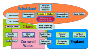
British megalith architecture is the study of those ancient cultures that built megalithic sites on the British Isles, including the research and documentation of these sites. The classification sometimes used of these cultures based on geological criteria is problematic.
A tor cairn is a prehistoric cult site occurring in the British Isles, especially in Cornwall and Devon but also in Wales. It consists of a circular enclosure of stones or a platform of loose rocks surrounding a natural tor, sometimes encircled by a ditch. The diameter of the roughly 35 tor cairns ranges from 12 to over 30 metres and their height varies from 0.5 to 4.0 metres. There is usually an entrance to the enclosed area and pits in the ground between the rock outcrop (tor) itself and the enclosure.

Trefignath is a Neolithic burial chamber near Trearddur, south of Holyhead on Holy Island, off Anglesey in Wales. In its most complete form it included a large cairn covering three stone tombs, set on a small knoll. It was excavated between 1977 and 1979, revealing several phases of occupation with three separate burial chambers built in succession. It is a scheduled ancient monument, maintained by Cadw.

Beacon Hill, also known as Harting Beacon, is a hillfort on the South Downs, in the county of West Sussex in southern England. The hillfort is located in the parish of Elsted and Treyford, in Chichester District. It is a Scheduled Ancient Monument with a list entry identification number of 1015915. The hilltop enclosure is dated to the Late Bronze Age, from the 8th to 6th centuries BC. The hillfort defences were renewed during the Late Iron Age.
