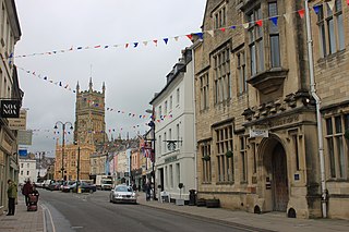
Cirencester is a market town in Gloucestershire, England, 80 miles (130 km) west of London. Cirencester lies on the River Churn, a tributary of the River Thames. It is the eighth largest settlement in Gloucestershire and the largest town within the Cotswolds. It is the home of the Royal Agricultural University, the oldest agricultural college in the English-speaking world, founded in 1840. The town had a population of 20,229 in 2021.
Cotswold is a local government district in Gloucestershire, England. It is named after the wider Cotswolds region and range of hills. The council is based in the district's largest town of Cirencester. The district also includes the towns of Chipping Campden, Fairford, Lechlade, Moreton-in-Marsh, Northleach, Stow-on-the-Wold and Tetbury, along with numerous villages and surrounding rural areas.

Rockhampton is a village and civil parish in the English county of Gloucestershire, situated in the unitary district of South Gloucestershire. It is located 2.8 miles (4.5 km) northeast of Thornbury, 18.6 miles (29.9 km) north of Bristol and is approximately 4 miles (6.4 km) east of the River Severn. It had a population of 166 people according to the 2011 census.

Chute is a civil parish in east Wiltshire, England, on the border with Hampshire. It includes the main village of Upper Chute and the smaller settlements of Lower Chute, Chute Standen, Chute Cadley and Mount Cowdown. The settlements are sometimes known collectively as "The Chutes". The nearest town is Andover, Hampshire, about 6 miles (10 km) to the southeast.

Tarrant Keyneston is a village and civil parish in Dorset, England. It is situated in the Tarrant Valley, five miles southeast of Blandford Forum. In the 2011 census the parish had 152 dwellings, 145 households and a population of 310.
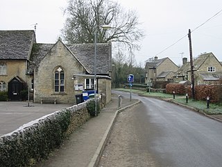
Kemble is a village in the civil parish of Kemble and Ewen, in the Cotswold district of Gloucestershire, England. Historically part of Wiltshire, it lies 4 miles (6.4 km) from Cirencester and is the settlement closest to Thames Head, the source of the River Thames. In 2020 it had an estimated population of 940. At the 2011 census the parish had a population of 1,036.

Charlton Kings is a contiguous village adjoining Cheltenham in Gloucestershire, England. The area constitutes a civil parish of 10,396 residents (2011).

Almeley is a village and civil parish in Herefordshire, England. The civil parish includes the hamlets of Almeley Wooton, Woonton and Upcott. The 2011 Census recorded the parish's population as 601.

Quenington is a nucleated village and larger rural civil parish in the Cotswold district of Gloucestershire, England, on the River Coln 8 miles (13 km) east of Cirencester and 2 miles (3.2 km) north of Fairford. It has a recorded population of 603 people as at the 2011 census.

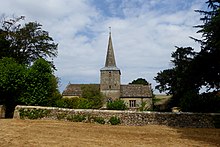
Barnsley is a village and civil parish in the Cotswold district of Gloucestershire, England, 3.7 miles (6.0 km) northeast of Cirencester. It is 125 kilometres (78 mi) (geodesically) west of London.
Bellerby is a village and civil parish in North Yorkshire, England, about 7 miles (11 km) south-west of Richmond. The village has one pub, the Cross Keys, a small and historic Anglican church and a Methodist chapel. It is 1.5 miles (2.4 km) from the market town of Leyburn. Bellerby is approximately 250 miles (400 km) north of London. Bellerby is situated 673 feet (205 m) above sea level and is surrounded by low-lying hills with an open south-easterly aspect. Moorland is located to the North and the West of the village. Becks are an attractive feature of the village, which boasts many. The residents of Bellerby are also proud of their large population of ducks who thrive in the becks and in the suitable gardens of many friendly residents. The closest big town is Leyburn.

Broadwell is a village and civil parish in the English county of Gloucestershire. It is about 1.5 miles (2.4 km) north of Stow-on-the-Wold, In the 2001 United Kingdom census, the parish had a population of 384. decreasing to 355 at the 2011 census.

Ravensworth is a village and civil parish in the Holmedale valley, within the Richmondshire district of North Yorkshire, England. It is approximately 4.5 miles (7.2 km) north-west of Richmond and 10 miles (16 km) from Darlington. The parish has a population of 255, according to the 2011 census.

Minety (/'maɪn.tiː/) is a village in north Wiltshire, England, between Malmesbury – 6 miles (9.7 km) to the west – and Swindon. It takes its name from the water mint plant found growing in ditches around the village, and has previously been known as Myntey. It has a primary school and a successful rugby club.
Alfred Hoare Powell (1865–1960) was an English Arts and Crafts architect, and designer and painter of pottery.
Oaksey is a village and civil parish in Wiltshire, England, on the county boundary with Gloucestershire. The village is about 5.5 miles (8.9 km) northeast of the market town of Malmesbury and a similar distance south of the Gloucestershire market town of Cirencester.

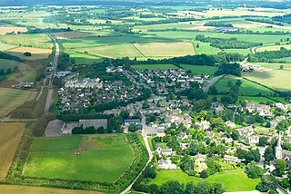
Siddington is a village and civil parish in Gloucestershire, England. It is located immediately south of Cirencester. At the 2011 United Kingdom Census, the parish had a population of 1,249.

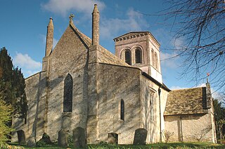
Coates is a village and civil parish situated in Cotswold District, Gloucestershire, England. It is around 3 miles (4.8 km) west of Cirencester and close to Cirencester Park, part of the Bathurst Estate. It is the nearest village to the source of the river Thames at Thames Head, and it is close to the course of the Foss Way or Fosse Way, the ancient Roman road. The nearest railway station is Kemble. The village population taken at the 2021 census was 491.
Langford is a village and civil parish in West Oxfordshire, about 3 miles (5 km) northeast of Lechlade in neighbouring Gloucestershire. The 2011 Census recorded the parish's population as 349.

The Rev. Prebendary James Dallaway FSA was an English antiquary, topographer, and miscellaneous writer. He is known for his account of Constantinople and the Greek islands, published in 1797; and his county history of the western parts of Sussex, of which he published two volumes in 1815–19.