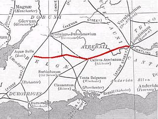
By the time of the Roman occupation of Calleva Atrebatum and Sorbiodunum, the road formed part of a longer route between Londinium (London) and Isca Dumnoniorum (Exeter). The term "Port Way" is sometimes used to refer to this whole route,[1] although the section between Londinium and Calleva Atrebatum is correctly known as The Devil's Highway, and the section between Sorbiodunum and Vindocladia (Badbury Rings) is Ackling Dyke.
Margary's Roman road numbering system, devised in the 1950s, gave the route from Londinium to Isca Dumnoniorum the number 4; the Port Way section is 4b. He recorded the distance of this section as 36+1⁄4 miles (58.3km).
Route
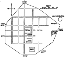
The road left Calleva Atrebatum at either the town's West Gate, the Lower West Gate to its south, or the South Gate
Less than 200 yards (180m) from Calleva Atrebatum, Port Way ran across an Iron Ageentrenchment near to where the 1985–87 Silchester Hoard of coins and rings was discovered.[18] The road passed near to (or cut across) the Flex Ditch near Silchester, another Iron Age earthwork.[19] It continued south-west through Pamber Forest, towards Cottington Hill near the present-day village of Hannington.[16]
From Cottington Hill, the road takes on the heading of Quarley Hill, near the present Hampshire–Wiltshire border, passes through St Mary Bourne and crosses the Bourne Rivulet.[2][20][21] Beyond St Mary Bourne, near Finkley and East Anton, Port Way was crossed by Margary route 43, the road from Venta Belgarum to Cunetio (Mildenhall)[2][22] sometimes described as being part of the Icknield Way.[23][24][25] Approximately 1 mile (1.6km) east of this crossroads was a mansio,[26][27] the only significant settlement on the Port Way other than its termini.[27] Hoare believed that this was the settlement of Vindomis,[28] and the Ordnance Survey's 25 inch to the mile map of 1895 marks it as "ROMAN STATION / Supposed to be VINDOMIS".[29]Charles Roach Smith wrote that the distance of Vindomis from Calleva Atrebatum given in the Antonine Itinerary – 15 miles (24km) – did not "materially clash" with the idea that Vindomis was the settlement at this intersection.[30] Despite this, Francis J. Haverfield wrote in 1915 that "there was no town or village at the crossing; so far as we know, there was not even a house at all".[31] Contrary to Hoare's belief that this was the site of Vindomis, the discovery of the Calleva Atrebatum to Noviomagus Reginorum (Chichester) road led to the consensus that the settlement was in the area of present-day Neatham near Alton.[32][33][34][35] No later than the 1730s, John Horsley had suggested that Vindomis was in the vicinity of Farnham (some 7 miles (11km) from Neatham).[36] If not Vindomis, the settlement at the East Anton crossroads may have been Leucomagus.[37]
At Sorbiodunum, the road entered the town at its Main Gate on the eastern side
Quarley Hill provided a line-of-sight with Sorbiodunum,[27] and from here the road took a south-west heading through the Bourne Valley into present-day Wiltshire, crossing the river between Winterbourne Gunner and Gomeldon. At Sorbiodunum, the road entered the town on its east side,[38] where it was met by Margary route 45a, the road from Venta Belgarum.[12] Beyond Sorbiodunum, the road continued south-west to Vindocladia (Badbury Rings) as Ackling Dyke (Margary route 4c),[39] west-south-west to Durnovaria as Margary route 4e, and finally west to Moridunum (near Axminster) and Isca Dumnoniorum (Exeter) as Margary route 4f.[12][lower-alpha 4]
Margary gave Portway the number 4b, and wrote that it was 36+1⁄4 miles (58.3km) long.[11] Both Calleva Atrebatum and Sorbiodunum are listed in Iter XV of the Antonine Itinerary, although the distance given between the two towns – 55 Roman miles[lower-alpha 5] – is via Vindomis and Venta Belgarum rather than a straight route along Port Way.[41]
In 1879, some 0.25 miles (0.40km) of the road near St Mary Bourne was removed to provide better access for farm vehicles. The metalled road surface was found between 4 and 8 inches (100 and 200mm) below ground level, and the road was approximately 24 feet (7.3m) wide.[2][11]
Further west, close to the Amesbury branch railway in the parish of Newton Tony, a section of the road in excellent preservation was carefully examined; Margary noted that both here and at Bradley Wood, the agger was 27 feet (8.2m) wide.[42] The road here was bottomed with chalk, then layered with 3–4 inches (76–102mm) of flint, upon which a 12-inch (300mm) layer of local gravel was laid.[43] The road had been cambered to give a thickness of 18 centimetres (7in) at the centre.[42] There were V-shaped ditches on each side of the road, each 1+1⁄4 feet (0.38m) deep and 3 feet (0.91m) wide.[43] These were situated roughly 32 feet (9.8m) from the south kerb and 34+1⁄4 feet (10.4m) from the north kerb, making a total width for the road zone of 84+1⁄4 feet (25.7m) to the ditch centres.[42]
Legacy
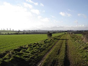
In 1851, Henry MacLauchlan reported that the route could not be distinguished from Calleva Atrebatum until the area of Wolverton and Ewhurst, where farmers could occasionally observe the effects of the road in their cornfields.[21] In 1889, Thomas William Shore described how the "great military road" could be traced to the gate in the wall at Calleva Atrebatum, although some of the Roman roads around the town had been "obliterated".[44] In 1903, Codrington was unable to definitively trace the route between Calleva Atrebatum and Cottington Hill,[2] although in the 1950s Margary stated that the agger was visible on the Tadley side of Pamber Forest and in farmland near Pamber Green, and traces of the road could be made out near Stoney Heath.[11] Like MacLauchlan and Codrington, Margary reported that tracing the route from this area was difficult, with little to be seen until the area of Hannington.[11] Here, the route of the road is now used by Meadham Lane, and a straight section of woodland known as Caesar's Belt is bordered on its north side by the road.[45] A track continues on the route of the road through Bradley Wood, where it is recognised as a scheduled monument.[46] After here, the course is lost to farmland.[47] In the St Mary Bourne area, the route occasionally dictates or influences field boundaries,[48] and at Middle Wyke, the Finkley Road follows its course into East Anton.[49] As it crosses the Anton Valley, the course of the road again disappears before being used by the Andover–Monxton road.[11][50] From here to Old Sarum, the alignment of the road is used by a number of lanes, tracks, and droves, as well as being paralleled by the West of England railway line as far as Idmiston.[51] Referring to the Ordnance Survey's dead-straight projection of the road's course, Margary wrote that "near Quarley and Grateley it seems probable that the distinct ridge along the south side of the wide green lane marks it rather than the Ordnance Survey’s idealized straight line in the fields where there is no sign of it."[11]
A number of roads along the course of Margary route 4 use the name "Portway", including the road following the course west of Gomeldon[58] and a residential road on The Devil's Highway in Riseley.[59] In Andover, Port Way has given its name to numerous places on the road's course west of the town centre, including a cul-de-sac, the West and East Portway roads, and two schools.[60][61][62] Both schools use the spoked wheel of a chariot in their crests.[61][62] Early 21st-century residential developments near the Port Way/Icknield Way crossroads at East Anton include The Chariots and Augusta Park,[63] and roads within the developments have been named after Roman emperors including Caesar, Claudius, Hadrian, Tiberius, and Vespasian, as well as Augustus's wife (and Tiberius's mother) Livia.[64]
↑ One suggestion is that Port Way forked south-west of the town, with the main road continuing to the Lower West Gate but a secondary route joining the Venta Belgarum road to connect to the South Gate[14]
Calleva Atrebatum was an Iron Age oppidum, the capital of the Atrebates tribe. It then became a walled town in the Roman province of Britannia, at a major crossroads of the roads of southern Britain.
The Roman road from Silchester to Bath connected Calleva Atrebatum (Silchester) with Aquae Sulis (Bath) via Spinae (Speen), Cunetio and Verlucio. The road was a significant route for east–west travel and military logistics in south-east England during the 1st to 5th centuries.
Little London is a village situated between the North Hampshire Downs and the gravel plains of the Kennet valley, 7 miles (11 km) north of Basingstoke and 15 miles (24 km) south of Reading. It is situated within Pamber civil parish and backs on to Pamber Forest, a 500-acre (2.0 km2) SSSI and remnant of the much larger ancient Royal Forest of Pamber. It is recorded as having been established for at least 400 years.
Roman roads in Britannia were initially designed for military use, created by the Roman Army during the nearly four centuries (AD 43–410) that Britannia was a province of the Roman Empire.
Silchester is a village and civil parish about 5 miles (8 km) north of Basingstoke in Hampshire. It is adjacent to the county boundary with Berkshire and about 9 miles (14 km) south-west of Reading.
Foudry Brook is a small stream in southern England. It rises from a number of springs near the Hampshire village of Baughurst, and flows to the east and then the north, to join the River Kennet to the south of Reading. The upper section is called Silchester Brook, and beyond that, Bishop's Wood Stream. The underlying geology is chalk, covered by a layer of clay, and so it has the characteristics of a clay stream, experiencing rapid increases in level after heavy rain due to run-off from the surrounding land. It passes a number of listed buildings and scheduled monuments, including the site of the Roman town of Calleva Atrebatum or Silchester.
Ermin Street or Ermin Way was a Roman road in Britain. It linked Glevum (Gloucester) and Corinium (Cirencester) to Calleva (Silchester).
Stratfield Saye is a small village and civil parish in the Borough of Basingstoke and Deane and the English county of Hampshire. The parish includes the hamlets of West End Green, Fair Oak Green and Fair Cross.
Tadley Calleva Football Club are a football club based in Tadley, Hampshire, England. The club is affiliated to the Hampshire Football Association. The club's name of Calleva comes from the nearby Roman Town of Calleva Atrebatum, based just outside Silchester. They play in the Combined Counties League Premier Division South.
Durocornovium was a Roman town in Britain, situated on the Roman road between Corinium Dobunnorum (Cirencester) and Calleva Atrebatum (Silchester). In many ways Durocornovium was a typical small Roman town.
Staines Bridge is a road bridge running in a south-west to north-east direction across the River Thames in Surrey. It is on the modern A308 road and links the boroughs of Spelthorne and Runnymede at Staines-upon-Thames and Egham Hythe. The bridge is Grade II listed.
Aldermaston Soke is a hamlet that lies on the county boundary between Berkshire and Hampshire, and is administratively part of the civil parish of Mortimer West End, which was transferred from Berkshire to Hampshire in 1879.
Mortimer West End is a village and civil parish in north Hampshire in England. It lies in the northernmost point of the county.
Woodlands St Mary is a small village in the English county of Berkshire. The village is situated in the civil parish of Lambourn, and is 3 miles (4.8 km) to the south of the village of Lambourn, and 1 mile (1.6 km) from Lambourn Woodlands. The parish is within the unitary authority of West Berkshire, close to the border between the counties of Berkshire and Wiltshire.
Ackling Dyke is a section of Roman road in England which runs for 22 miles (35 km) southwest from Old Sarum (Sorviodunum) to the hill fort at Badbury Rings (Vindocladia). Part of the road on Oakley Down has been scheduled as an ancient monument.
The Chichester to Silchester Way is a Roman Road between Chichester in South-East England, which as Noviomagus was capital of the Regni, and Silchester or Calleva Atrebatum, capital of the Atrebates. The road had been entirely lost and forgotten, leaving no Saxon place names as clues to its existence, until its chance discovery through aerial photography in 1949. Only 6 kilometres (3.7 mi) of the 62 kilometres (39 mi) long road remain in use.
Camlet Way was a Roman road in England which ran roughly east–west between Colchester (Camalodunum) in Essex and Silchester in Hampshire via St Albans (Verulamium). Camlet Way crossed the River Thames by bridge at Hedsor Wharf to Sashes Island near Cookham in Berkshire.
The Frith is a small univallate Iron Age hillfort to the north of Silchester, Calleva Atrebatum, Roman town in the English county of Hampshire. A single bank covers all sides apart from the south east, and is at the most about 5 feet (1.5 m) high on the western edge. A ditch is also traceable for the length of the bank, although at varying states.
The Silchester Ogham stone is a pillar stone discovered at the Roman town on Calleva Atrebatum in Silchester, Hampshire during excavations in 1893. Thus far it remains the only one of its kind found in England, and the only ogham inscription in England east of Cornwall and Devon. The stone is held in a storage facility of Reading Museum in Reading, Berkshire.
The Devil's Highway was a Roman road in Britain connecting Londinium (London) to Calleva Atrebatum (Silchester) via Pontes (Staines). The road was the principal route to the west of Britain during the Roman period but whilst maintained for its easternmost section, was replaced by other routes after the demise of Roman Britain.
↑ Hinton, David Alban (1988). Hampshire and the Isle of Wight. London: Philip / Ordnance Survey. p.42. ISBN9780540011377.
1 2 Bailey, Stephen (2019). The old roads of Derbyshire: walking into history: the Portway and beyond. Kibworth Beauchamp: Troubador Publishing. p.6. ISBN9781789018431.
↑ Gasper, Giles E. M.; Gullbekk, Svein H. (2016). Money and the church in medieval Europe, 1000-1200: practice, morality and thought. Burlington, VT: Taylor & Francis. p.162. ISBN9781317094364.
↑ Fulford, M. G.; Burnett, A.; Henig, M.; Johns, C. (1989). "A Hoard of Late Roman Rings and Silver Coins from Silchester, Hampshire". Britannia. 20: 220. doi:10.2307/526164. JSTOR526164.
↑ Fulford, M. G.; Burnett, A.; Henig, M.; Johns, C. (1989). "A Hoard of Late Roman Rings and Silver Coins from Silchester, Hampshire". Britannia. 20: 219–220. doi:10.2307/526164. JSTOR526164.
This page is based on this Wikipedia article Text is available under the CC BY-SA 4.0 license; additional terms may apply. Images, videos and audio are available under their respective licenses.