Lawrence J. Timmerman Airport, known locally as Timmerman Field, is an airport in Milwaukee, Wisconsin, United States, owned by Milwaukee County. Located 5 miles (8 km) northwest of the city center, it is used mainly for general or private aviation. It is included in the Federal Aviation Administration (FAA) National Plan of Integrated Airport Systems for 2019–2023, in which it is categorized as a regional reliever airport facility.

Watertown Municipal Airport is a public use airport located in and owned by the city of Watertown, in Jefferson County, Wisconsin, United States. It is included in the Federal Aviation Administration (FAA) National Plan of Integrated Airport Systems for 2019–2023, in which it is categorized as a regional general aviation facility.
Coffey County Airport is a county-owned public-use airport located seven miles (11 km) north of the central business district of Burlington, a city in Coffey County, Kansas, United States.

Hutchinson Municipal Airport, also known as Butler Field, is a public airport located two miles (3 km) south of the central business district of Hutchinson, a city in McLeod County, Minnesota, United States. It is owned by the City of Hutchinson. The airport is home to the Civil Air Patrol. The FBO is operated by ASI JET.

'Waukesha County Airport/Crites Field, is a public use airport located two miles (3 km) north of the central business district of Waukesha, a city in Waukesha County, Wisconsin, United States. It is owned and operated by Waukesha County. It is included in the Federal Aviation Administration (FAA) National Plan of Integrated Airport Systems for 2019–2023, in which it is categorized as a national reliever aviation facility.

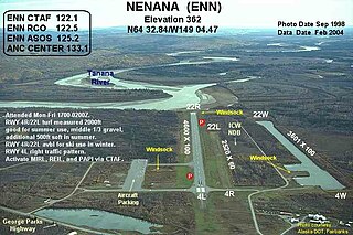
Nenana Municipal Airport is a city-owned public-use airport located one mile (1.6 km) south of the central business district of Nenana, a city in the Yukon-Koyukuk Census Area of the U.S. state of Alaska.
Skyhaven Airport is a public-use airport located three miles (5 km) northwest of the central business district of Warrensburg, a city in Johnson County, Missouri, United States. It is owned by the University of Central Missouri.
Skagit Regional Airport is a public airport located three miles (5 km) west of the central business district of Burlington and northwest of Mount Vernon, both cities in Skagit County, Washington, United States. The airport is owned by the Port of Skagit County. It is situated in the Bayview Industrial Park.
Dalton Municipal Airport is a city-owned public-use airport located six miles (10 km) southeast of the central business district of Dalton, a city in Whitfield County, Georgia, United States.

Hartness State Airport is a public airport located three miles (5 km) northwest of the central business district of Springfield, a town in Windsor County, Vermont, United States. It is owned by the State of Vermont.
Rawlins Municipal Airport is a public airport two miles (3 km) northeast of Rawlins, in Carbon County, Wyoming. The Rawlins Carbon County Airport Board owns it.

Leesburg International Airport, formerly known as Leesburg Regional Airport, is a public airport located three miles (5 km) northeast of the central business district of Leesburg, a city in Lake County, Florida, United States. It is owned by the City of Leesburg.

Wharton Regional Airport is a public airport located five miles (8 km) southwest of the central business district of Wharton, a city in Wharton County, Texas, United States. It is owned by the City of Wharton.

Monticello Regional Airport, formerly known as Monticello Municipal Airport, is a public airport located two miles (3 km) southeast of the central business district of Monticello, a city in Jones County, Iowa, United States. It is owned by the City of Monticello.
Hobart Regional Airport is three miles southeast of Hobart, in Kiowa County, Oklahoma.

La Porte Municipal Airport is a city-owned public-use airport located three miles (5 km) south of the central business district of La Porte, a city in La Porte County, Indiana, United States.

Willmar Municipal Airport, also known as John L. Rice Field, is a city-owned public-use airport located west of the central business district of Willmar, a city in Kandiyohi County, Minnesota, United States. The airport opened in 2006 and is located two miles west of a closed airport which operated under the same name.

Mason County Airport is a county-owned public-use airport located two miles (3 km) northeast of the central business district of Ludington, a city in Mason County, Michigan, United States.

Skyhaven Airport is a public-use airport located three miles (5 km) southeast of the central business district of Rochester, a city in Strafford County, New Hampshire, United States. The airport is owned and operated by the Pease Development Authority, with fixed-base operator (FBO) services provided by Skyhaven Aviation Services. It is included in the Federal Aviation Administration (FAA) National Plan of Integrated Airport Systems for 2017–2021, in which it is categorized as a local general aviation facility.

Northeast Iowa Regional Airport is a public airport located three miles (5 km) east of the central business district of Charles City, in Floyd County, Iowa, United States. It is owned by the North Cedar Aviation Authority and was formerly known as Charles City Municipal Airport.


