The Leine is a river in Thuringia and Lower Saxony, Germany. It is a left tributary of the Aller and the Weser and is 281 km (175 mi) long.
Amt is a type of administrative division governing a group of municipalities, today only in Germany, but formerly also common in other countries of Northern Europe. Its size and functions differ by country and the term is roughly equivalent to a British or U.S. county.

Liebenburg is a municipality in the district of Goslar, in Lower Saxony, Germany.
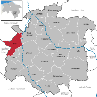
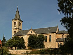
Elze is a town in the district of Hildesheim, in Lower Saxony, Germany. It is situated on the river Leine, approximately 15 km (9.3 mi) west of Hildesheim. The municipality of Elze also comprises the villages of Esbeck, Mehle, Sehlde, Sorsum, Wittenburg and Wülfingen.

Freden is a village and a municipality in the district of Hildesheim, in Lower Saxony, Germany. It is situated on the river Leine, approx. 25 km south of Hildesheim. Since 1 November 2016, the former municipalities Everode, Landwehr and Winzenburg are part of the municipality Freden.

Lamspringe is a village and a municipality in the district of Hildesheim, in Lower Saxony, Germany. It is situated approximately 20 km south of Hildesheim. Since 1 November 2016, the former municipalities Harbarnsen, Neuhof, Sehlem and Woltershausen are part of the municipality Lamspringe. Glashütte is a district of the Lamspringe community and located around 4 km east of Lamspringe on the L 466 state road to Rhüden in the Schlörbach valley. In the 18th century, the Lamspringe monastery founded a forest glassworks. It was located in the extensive wooded area of the Westerhof monastery forest, which borders the Heber ridge. In 1792 Johann Friedrich Stender from Ziegenhagen resumed glass production in the monastery forest and founded a glassworks with the Stender glass factory. The Glashütte settlement, for which the company was named, emerged from it.

A burgstall is a German term referring to a castle of which so little is left that its appearance cannot effectively be reconstructed. It has no direct equivalent in English, but may be loosely translated as "castle site". Variations in the literature include Burgstelle, Altburgstelle, die Burgställe (plural), Burgstähl (archaic) or abgegangene Burg. In German castle studies, a burgstall is a castle that has effectively been levelled, whereas a "ruin" (Ruine) still has recognisable remnants of the original castle above the level of the ground.
The Innerste is a river in Lower Saxony, Germany. It is a right tributary of the Leine river and 101 km (63 mi) in length.

Plüderhausen is a municipality east of Schorndorf in the Rems-Murr district in Baden-Württemberg, Germany. It belongs to the Stuttgart Metropolitan Region.

Arnschwang is a rural municipality in the district of Cham in Bavaria, Germany. The population was 2,004 as of the 2010 census. In recent years Arnschwang has focused on the production of environmentally friendly energy from biomass and water.
Everode is a village and a former municipality in the district of Hildesheim in Lower Saxony, Germany. Since 1 November 2016, it is part of the municipality Freden.
Landwehr is a village and a former municipality in the district of Hildesheim in Lower Saxony, Germany. Since 1 November 2016, it is part of the municipality Freden.
Freden is a former Samtgemeinde in the district of Hildesheim, in Lower Saxony, Germany. Its seat was in the village Freden. On 1 November 2016 it was dissolved.

Hödekin is a kobold of German folklore. The name is a diminutive meaning "Little Hat", and refers to the hat he wears, explained as being a pileus a felt hat of certain shapes.

Marienburg Castle is a well-preserved Romanesque castle in Hildesheim, a city in Lower Saxony, Germany.

The Leine-Heide Cycle Path is a long-distance cycle path in Germany that has a total length of 410 kilometres (250 mi) and runs through the German federal states of Thuringia, Lower Saxony and Hamburg. Until 2009, it was called the Leine Cycle Path, after the River Leine; it ended north of the river's confluence with the Aller in Hodenhagen. Heide (‘heath’) refers to the Lüneburg Heath.

The Sackwald is a ridge, up to 374 m above sea level (NN) high, in the Lower Saxon Hills in the district of Hildesheim in the North German state of Lower Saxony. It is named after the village of Sack in the borough of Alfeld, the name meaning "Sack Forest".

The Selter is a ridge, up to 395 m above NN, in the Lower Saxon Hills in the districts of Hildesheim, Holzminden and Northeim in the German state of Lower Saxony.

The Helleberg is a hill ridge up to 297.5 m above NN in the Lower Saxon Hills and within the counties of Hildesheim and Northeim in Lower Saxony, Germany.