Parczew County is a unit of territorial administration and local government (powiat) in Lublin Voivodeship, eastern Poland. It was established on January 1, 1999, as a result of the Polish local government reforms passed in 1998. Its administrative seat and only town is Parczew, which lies 48 kilometres (30 mi) north-east of the regional capital Lublin.
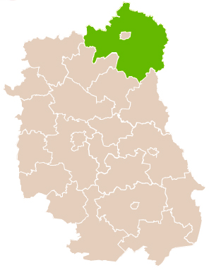
Łuków County is a unit of territorial administration and local government (powiat) in Lublin Voivodeship, eastern Poland. It was established on January 1, 1999, as a result of the Polish local government reforms passed in 1998. Its administrative seat and largest town is Łuków, which lies 76 kilometres (47 mi) north of the regional capital Lublin. The only other town in the county is Stoczek Łukowski, lying 30 km (19 mi) west of Łuków.
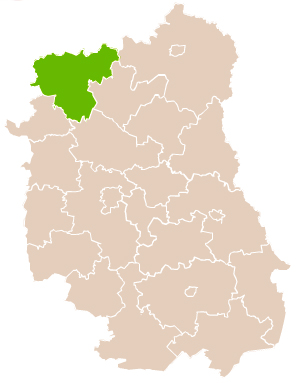
Biała County is a county in Lublin Voivodeship, eastern Poland, on the border with Belarus. It was established on January 1, 1999, as a result of the Polish local government reforms passed in 1998. Its administrative seat is the city of Biała Podlaska, although the city is not part of the county. The only towns in Biała Podlaska County are Międzyrzec Podlaski, which lies 24 km (15 mi) west of Biała Podlaska, and the border town of Terespol, 32 km (20 mi) east of Biała Podlaska.
Gmina Drelów is a rural gmina in Biała Podlaska County, Lublin Voivodeship, in eastern Poland. Its seat is the village of Drelów, which lies approximately 21 kilometres (13 mi) south-west of Biała Podlaska and 78 km (48 mi) north of the regional capital Lublin.
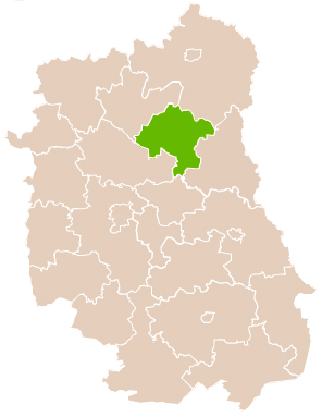
Gmina Komarówka Podlaska is a rural gmina in Radzyń Podlaski County, Lublin Voivodeship, in eastern Poland. Its seat is the village of Komarówka Podlaska, which lies approximately 23 kilometres (14 mi) east of Radzyń Podlaski and 67 km (42 mi) north-east of the regional capital Lublin.
Gmina Wohyń is a rural gmina in Radzyń Podlaski County, Lublin Voivodeship, in eastern Poland. Its seat is the village of Wohyń, which lies 12 kilometres (7 mi) east of Radzyń Podlaski and 58 km (36 mi) north of the regional capital Lublin.
Podlaski may refer to the following places:
Brzeziny is a village in the administrative district of Gmina Komarówka Podlaska, within Radzyń Podlaski County, Lublin Voivodeship, in eastern Poland. It lies approximately 4 kilometres (2 mi) west of Komarówka Podlaska, 19 km (12 mi) east of Radzyń Podlaski, and 67 km (42 mi) north of the regional capital Lublin.
Brzozowy Kąt is a village in the administrative district of Gmina Komarówka Podlaska, within Radzyń Podlaski County, Lublin Voivodeship, in eastern Poland. It lies approximately 5 kilometres (3 mi) south-east of Komarówka Podlaska, 27 km (17 mi) east of Radzyń Podlaski, and 67 km (42 mi) north-east of the regional capital Lublin.
Derewiczna is a village in the administrative district of Gmina Komarówka Podlaska, within Radzyń Podlaski County, Lublin Voivodeship, in eastern Poland. It lies approximately 3 kilometres (2 mi) south-west of Komarówka Podlaska, 21 km (13 mi) east of Radzyń Podlaski, and 65 km (40 mi) north of the regional capital Lublin.
Kolembrody is a village in the administrative district of Gmina Komarówka Podlaska, within Radzyń Podlaski County, Lublin Voivodeship, in eastern Poland. It lies approximately 8 kilometres (5 mi) north-east of Komarówka Podlaska, 29 km (18 mi) east of Radzyń Podlaski, and 74 km (46 mi) north-east of the regional capital Lublin.

Komarówka Podlaska is a village in Radzyń Podlaski County, Lublin Voivodeship, in eastern Poland. It is the seat of the gmina called Gmina Komarówka Podlaska. It lies approximately 23 kilometres (14 mi) east of Radzyń Podlaski and 67 km (42 mi) north-east of the regional capital Lublin.
Przegaliny Duże is a village in the administrative district of Gmina Komarówka Podlaska, within Radzyń Podlaski County, Lublin Voivodeship, in eastern Poland. It lies approximately 6 kilometres (4 mi) north-west of Komarówka Podlaska, 19 km (12 mi) east of Radzyń Podlaski, and 69 km (43 mi) north of the regional capital Lublin.
Przegaliny Małe is a village in the administrative district of Gmina Komarówka Podlaska, within Radzyń Podlaski County, Lublin Voivodeship, in eastern Poland. It lies approximately 7 kilometres (4 mi) west of Komarówka Podlaska, 17 km (11 mi) east of Radzyń Podlaski, and 66 km (41 mi) north of the regional capital Lublin.
Walinna is a village in the administrative district of Gmina Komarówka Podlaska, within Radzyń Podlaski County, Lublin Voivodeship, in eastern Poland. It lies approximately 5 kilometres (3 mi) north-east of Komarówka Podlaska, 26 km (16 mi) east of Radzyń Podlaski, and 71 km (44 mi) north-east of the regional capital Lublin.
Wólka Komarowska is a village in the administrative district of Gmina Komarówka Podlaska, within Radzyń Podlaski County, Lublin Voivodeship, in eastern Poland. It lies approximately 3 kilometres (2 mi) north-east of Komarówka Podlaska, 24 km (15 mi) east of Radzyń Podlaski, and 70 km (43 mi) north-east of the regional capital Lublin.
Woroniec is a village in the administrative district of Gmina Komarówka Podlaska, within Radzyń Podlaski County, Lublin Voivodeship, in eastern Poland. It lies approximately 6 kilometres (4 mi) east of Komarówka Podlaska, 28 km (17 mi) east of Radzyń Podlaski, and 70 km (43 mi) north-east of the regional capital Lublin.
Żelizna is a village in the administrative district of Gmina Komarówka Podlaska, within Radzyń Podlaski County, Lublin Voivodeship, in eastern Poland. It lies approximately 8 kilometres (5 mi) north of Komarówka Podlaska, 25 km (16 mi) north-east of Radzyń Podlaski, and 74 km (46 mi) north of the regional capital Lublin.
Żulinki is a village in the administrative district of Gmina Komarówka Podlaska, within Radzyń Podlaski County, Lublin Voivodeship, in eastern Poland. It lies approximately 4 kilometres (2 mi) north of Komarówka Podlaska, 23 km (14 mi) east of Radzyń Podlaski, and 71 km (44 mi) north of the regional capital Lublin.
Zbulitów Duży is a village in the administrative district of Gmina Radzyń Podlaski, within Radzyń Podlaski County, Lublin Voivodeship, in eastern Poland. It lies approximately 7 kilometres (4 mi) east of Radzyń Podlaski and 59 km (37 mi) north of the regional capital Lublin.
