
Summit Lake Provincial Park is a Class C provincial park located southeast of the community of Summit Lake in the Central Kootenay region of British Columbia, Canada.

Sugarloaf Mountain is a ski mountain located in Carrabassett Valley, Franklin County, Maine. It is the third highest peak in the state, after Mount Katahdin's Baxter and Hamlin peaks. Sugarloaf is flanked to the south by Spaulding Mountain.

Waterrock Knob is a mountain peak in the U.S. state of North Carolina. It is the highest peak in the Plott Balsams and is the 16th-highest mountain in the Eastern United States.

Old Speck Mountain, also known as Old Speckle Mountain, is a mountain located in Oxford County, Maine, United States. The mountain, the fourth-highest in the state, is the northeasternmost and highest of the Mahoosuc Range, the northeasternmost part of the White Mountains. Old Speck is flanked to the southwest by Mahoosuc Arm, and faces Baldpate Mountain to the northeast across Grafton Notch.

Static Peak is located in the Teton Range, Grand Teton National Park, in the U.S. state of Wyoming. Located .48 miles (0.77 km) southeast of Buck Mountain, the summit is also east of the Alaska Basin Trail, from a point known as Static Peak Divide, the summit can be climbed in a scramble. Below the summit on the north face, a small remnant glacier persists, sheltered from direct sunlight by steep cliffs. Timberline Lake lies to the north of the peak.
Gau-Weinheim is an Ortsgemeinde – a municipality belonging to a Verbandsgemeinde, a kind of collective municipality – in the Alzey-Worms district in Rhineland-Palatinate, Germany.

Big Slide Mountain is a mountain in the High Peaks Region of the Adirondack Park in New York. The mountain is the twenty-seventh highest peak in the High Peaks Region. The peak was named for the prominent steep cliff that rises to its summit. It is located in the High Peaks Wilderness Area.

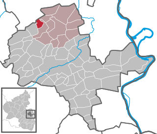
Sankt Johann is an Ortsgemeinde – a municipality belonging to a Verbandsgemeinde, a kind of collective municipality – in the Mainz-Bingen district in Rhineland-Palatinate, Germany.

Mount Emmons is a mountain located in the Adirondack Mountains near the southern edge of Franklin County, New York, United States.
Rounds Mountain, 2,257 feet (688 m), is a prominent peak in the Taconic Mountains of western Massachusetts and adjacent New York. The west side of the mountain and summit are located in New York; the east side is located within Massachusetts. The summit a bald; the slopes are wooded with northern hardwood tree species. It is notable for its views of the Hudson River Valley to the west and the Green River and Kinderhook Creek valleys of Hancock, Massachusetts to the east. The 35 mi (56 km) Taconic Crest Trail traverses the mountain. Much of the upper slopes and summit are within protected conservation land.
Alander Mountain is a 2,241-foot-tall (683 m) prominent peak of the south Taconic Mountains; it is located in southwest Massachusetts and adjacent New York. Part of the summit is grassy and open and part is covered with scrub oak and shrubs; the sides of the mountain are wooded with northern hardwood tree species. Views from the top include the southern Taconic Mountains, the Hudson River Valley including the Catskills. Several trails traverse Alander Mountain, most notably the 15.7 mi (25.3 km) South Taconic Trail, which passes just beneath the summit.

Mica Peak is the name of two separate mountain summits in the United States located approximately 5.49 miles (9 km) apart; one in Spokane County, Washington and the other in Kootenai County, Idaho. The two peaks are located along the same ridge, which separates the Spokane Valley and Rathdrum Prairie from the Palouse. The mountains have an elevation difference of only 31 ft (9.4 m) and are the southernmost peaks of the Selkirk Mountains.

Monument Mountain is the name of a popular 503-acre (204 ha) open space reservation located in Great Barrington, Massachusetts on the southeast side of Monument Mountain. The reservation is centered on the 1,642 feet (500 m) subordinate summit of Peeskawso Peak. It is managed by The Trustees of Reservations, a non-profit conservation organization and is notable for its expansive views of the Housatonic River Valley, The Berkshires, the Taconic Mountains, and the Catskill Mountains of New York from the knife-edge summit of Peeskawso Peak. Monument Mountain, composed of erosion resistant quartzite, is of The Berkshires geology. The reservation receives more than 20,000 visitors a year.

Summit Bridge is an unincorporated community in New Castle County, Delaware, United States. Summit Bridge is home to Summit Airport, located five miles north of the central business district of Middletown. Summit Bridge is located south of the Summit Bridge over the Chesapeake and Delaware Canal.
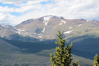
Fairchild Mountain is a high mountain summit in the Mummy Range of the Rocky Mountains of North America. The 13,508-foot (4,117 m) thirteener is located in the Rocky Mountain National Park Wilderness, 9.6 miles (15.5 km) northwest of the Town of Estes Park in Larimer County, Colorado, United States.

Mount Chiquita is a mountain summit in the Mummy Range of the Rocky Mountains of North America. The 13,075-foot (3,985 m) thirteener is located in Rocky Mountain National Park, 9.8 miles (15.7 km) northwest by west of the Town of Estes Park in Larimer County, Colorado, United States.
Dollarhide Mountain, at 9,301 feet (2,835 m) above sea level is a peak in the Smoky Mountains of Idaho. The peak is located in Sawtooth National Forest on the border of Blaine and Camas counties. It is located about 4.2 mi (6.8 km) south of Baker Peak. Forest road 227 travels near the peak over a road pass known as Dollarhide Summit. No roads or trails go to the summit.

The Usser Wissberg is a mountain of the Oberhalbstein Alps, overlooking the Avers valley, west of Piz Platta, in the canton of Graubünden.

The Old Stone Church is a historic sandstone church located in Kingwood Township in Hunterdon County, New Jersey. It was built in 1837 and is now owned by the First Unitarian Universalist Fellowship of Hunterdon County. The church, described using its historic name, Old Stone Presbyterian Church in Kingwood, was added to the National Register of Historic Places on January 25, 2018 for its significance in architecture. The earlier church located here was a smaller stone building built in 1755, called the Old Stone Meetinghouse. The stones from this church were probably used to build the current one. The Kingwood congregation was established in 1728 and grew during the First Great Awakening, with Gilbert Tennent and George Whitefield preaching here in 1739.

Baldy Cinco, elevation 13,379 feet, is a mountain in Hinsdale and Mineral counties in southern Colorado. The mountain, a thirteener, is located on the Continental Divide in the San Juan Mountains. Different areas of the slopes of Baldy Cinco lie in the Rio Grande National Forest, the La Garita Wilderness, and the Gunnison National Forest. The mountain is located just north of Snow Mesa and east northeast of Spring Creek Pass.

