
Socorro County is a county in the U.S. state of New Mexico. As of the 2020 census, the population was 16,595. The county seat is Socorro. The county was formed in 1852 as one of the original nine counties of New Mexico Territory. Socorro was originally the name given to a Native American village by Don Juan de Oñate in 1598. Having received vitally needed food and assistance from the native population, Oñate named the pueblo Socorro.

Catron County is a county in the U.S. state of New Mexico. As of the 2020 census, the population was 3,579, making it New Mexico's third-least populous county. Its county seat is Reserve. Catron County is New Mexico's largest county by area.

The Apache–Sitgreaves National Forests is a 2.76-million-acre (11,169 km2) United States National Forest which runs along the Mogollon Rim and the White Mountains in east-central Arizona and into the U.S. state of New Mexico. Formerly two forests, it is currently managed as one unit by USDA Forest Service from the Forest Supervisors Office in Springerville, Arizona. Apache–Sitgreaves has over 400 species of wildlife. With its high elevation and cool summer breezes it is a popular weekend destination from the hot desert for Phoenix, Arizona, residents. The forest is divided into 5 Ranger Districts that span almost 300 miles (480 km) from Clifton, Arizona in the east-central portion of Arizona to the eastern boundary of the Coconino National Forest in north-central Arizona. The Apache–Sitgreaves National Forest borders the western and northern borders of the Fort Apache Indian Reservation. It is located in parts of Greenlee, Apache, Navajo, and Coconino counties in eastern and east-central Arizona, and Catron County in western New Mexico. The more northwesterly Sitgreaves National Forest portion lies adjacent to the north side of the Fort Apache Indian Reservation and is located entirely in Arizona, within Navajo, Apache, and Coconino counties. It has a total area of 818,651 acres (3,313 km2). The more southeasterly and much larger Apache National Forest portion lies adjacent to the east side of the Fort Apache and the San Carlos Indian Reservations. It lies on both sides of the border with New Mexico, in Greenlee, Catron, and Apache counties. It has a total area of 1,813,601 acres (7,339 km2).

The Cleveland National Forest encompasses 460,000 acres/720 sq mi (1,900 km2) of inland montane regions—approx. 60 miles from the Pacific Ocean—within the counties of San Diego, Riverside, and Orange, California. The landscape varies somewhat, with mostly chaparral canyons, arroyos and high desert, but dotted with meadows and oak and conifer forests. Near water sources, riparian environments and perennial aquatic plants attract native and migratory wildlife, such as at San Diego’s man-made Lake Cuyamaca. A generally warm and dry, inland-Mediterranean climate prevails over the forest, with the cooler months producing morning frost and snowfall. It is the southernmost U.S. National Forest of California. The area is administered by the U.S. Forest Service, a government agency within the United States Department of Agriculture, and is locally overseen by the Descanso, Palomar and Trabuco Ranger Districts.

The Cibola National Forest is a 1,633,783 acre United States National Forest in New Mexico, US. The name Cibola is thought to be the original Zuni Indian name for their pueblos or tribal lands. The name was later interpreted by the Spanish to mean "buffalo." The forest is disjointed with lands spread across central and northern New Mexico, west Texas and Oklahoma. The Cibola National Forest is divided into four Ranger Districts: the Sandia, Mountainair, Mt. Taylor, and Magdalena. The Forest includes the San Mateo, Magdalena, Datil, Bear, Gallina, Manzano, Sandia, Mt. Taylor, and Zuni Mountains of west-central New Mexico. The Forest also manages four National Grasslands that stretch from northeastern New Mexico eastward into the Texas Panhandle and western Oklahoma. The Cibola National Forest and Grassland is administered by Region 3 of the United States Forest Service from offices in Albuquerque, New Mexico. Elevation ranges from 5,000 ft to 11,301 ft. The descending order of Cibola National Forest acres by county are: Socorro, Cibola, McKinley, Catron, Torrance, Bernalillo, Sandoval County, New Mexico, Lincoln, Sierra, and Valencia counties in New Mexico. The Cibola National Forest currently has 137,701 acres designated as Wilderness. In addition to these acres, it has 246,000 acres classified as Inventoried Roadless Areas pursuant to the Roadless Area Conservation Rule.

The Gila National Forest is a United States National Forest in New Mexico. Established in 1905, it now covers approximately 2,710,659 acres (10,969.65 km2), making it the sixth largest National Forest in the continental United States. The Forest administration also manage the part of the Apache National Forest in New Mexico which covers 614,202 acres for a total of 3.3 million acres managed by the Gila National Forest. Within the forest, the Gila Wilderness was established in 1924 as the US's first designated wilderness. The Aldo Leopold Wilderness and Blue Range Wilderness are also found within its borders. The Blue Range Primitive Area lies within Arizona in the neighboring Apache National Forest.

Lincoln National Forest is a unit of the U.S. Forest Service located in southern New Mexico. The Lincoln National Forest covers an extensive 1.1 million acres in southeastern New Mexico. Established by Presidential Proclamation in 1902 as the Lincoln Forest Reserve, the 1,103,897 acres (4,467.31 km2) forest begins near the Texas border and contains lands in parts of Chaves, Eddy, Lincoln, and Otero counties. The Lincoln National Forest is home to three major mountain ranges: Sacramento, Guadalupe and Capitan. The three Ranger Districts within the forest contain all or part of a total of four mountain ranges, and include a variety of different environmental areas, from desert to heavily forested mountains and sub-alpine grasslands. Clean air, water, and soil are necessary elements that the National Forests contribute to the environment. Established to balance conservation, resource management, and recreation, the lands of the Lincoln National Forest include important local timber resources, protected wilderness areas, and popular recreation and winter sports areas. The forest headquarters is located in Alamogordo, N.M. with local offices in Carlsbad, Cloudcroft, and Ruidoso.

The Magdalena Mountains are a regionally high, mountain range in Socorro County, in west-central New Mexico in the southwestern United States. The highest point in the range is South Baldy, at 10,783 ft, which is also the tallest peak in Socorro County. The range runs roughly north-south and is about 18 miles (28 km) long. The range lies just south of the village of Magdalena, and about 18 miles (28 km) west of Socorro. The Magdalena Mountains are an east-tilted fault-block range, superimposed on Cenozoic calderas. The complex geologic history of the range has resulted in spectacular scenery, with unusual and eye-catching rock formations. They form part of the western edge of the Rio Grande Rift Valley, fronting the La Jencia Basin. The mountains remain isolated and natural due to the absence of any significant human development within or near the range.

South Baldy is the highest point of the Magdalena Mountains in central New Mexico, in the United States. It is in the Magdalena Ranger District of the Cibola National Forest, about 9 mi (15 km) south of Magdalena and 18 mi (30 km) west-southwest of Socorro. It lies just north of the Langmuir Laboratory for Atmospheric Research of the New Mexico Institute of Mining and Technology, and site of the Magdalena Ridge Observatory Interferometer.

The San Mateo Mountains are a mountain range in Socorro County, in west-central New Mexico in the southwestern United States. The highest point in the range is West Blue Mountain, at 10,336 ft. The range runs roughly north-south and is about 40 miles (64 km) long. It lies about 25 miles (40 km) north-northwest of the town of Truth or Consequences and about 30 miles (48 km) southwest of Socorro. They should not be confused with the identically named range in Cibola and McKinley counties, north of this range.
The San Mateo Mountains are a small mountain range in Cibola and McKinley counties of New Mexico, in the southwestern United States. The highest point in the range is Mount Taylor, at 11,301 ft. The range lies just northeast of the community of Grants, and about 60 miles (100 km) west of Albuquerque. This range should not be confused with the identically named range in Socorro County, south of this range.
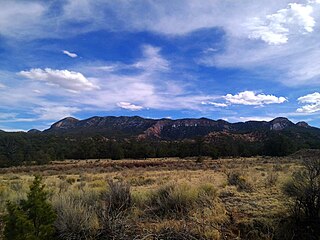
Apache Kid Wilderness is a 44,626-acre (18,060 ha) Wilderness area located within the Magdalena Ranger District of the Cibola National Forest in the state of New Mexico. Straddling a southern portion of the San Mateo Mountains of southwestern Socorro County, the area is characterized by rugged, narrow, and steep canyons bisecting high mountain peaks exceeding 10,000 feet (3,000 m). The highest peak is West Blue Mountain which reaches an elevation of 3,151 metres (10,338 ft).
Magdalena National Forest was established as the Magdalena Forest Reserve by the U.S. Forest Service in New Mexico on November 5, 1906, with 153,781 acres (622.33 km2). It became a National Forest on March 4, 1907. On July 1, 1908, San Mateo National Forest was added. On February 23, 1909, the forest was combined with Datil National Forest
The White Mountain Wilderness is a 46,963 acre designated wilderness area managed by the United States Forest Service. Located in the Smokey Bear Ranger District of the Lincoln National Forest, the White Mountain Wilderness lies in the Sierra Blanca mountains of south central New Mexico, approximately 15 miles (24 km) north northwest of the town of Ruidoso.

Manzano Mountain Wilderness is a designated Wilderness Area within the Cibola National Forest, located about 50 miles (80 km) south-southeast of Albuquerque. It is located in western Torrance County and eastern Valencia County. The Wilderness area includes 36,875 acres (14,923 ha) with elevations ranging from 6,100 feet (1,900 m) to 10,098 feet (3,078 m) at Manzano Peak.
The Datil Mountains are a small range on the northern edge of the Mogollon-Datil volcanic field, just northwest of the Plains of San Agustin in the U.S. state of New Mexico. The range lies in Socorro and Catron Counties, north of the town of Datil, New Mexico and takes its name from the Spanish word for “date,” dating back over two hundred years. In The Place Names of New Mexico, Robert Julyan suggests two possible explanations for the name: 1) that “the seedpods of the broad-leafed yucca sufficiently resembled dates” or 2) “the Spanish applied the name to the fruit of the prickly pear cactus.” The area includes the major ridgeline of Madre Mountain, which is sacred ground to the Acoma, Laguna, and Zuni tribes, as well as several other unnamed peaks and ridges.

The Bear Mountains lie just north of the village of Magdalena and north of the Magdalena Mountains in New Mexico. The Bear Mountains are located within the Magdalena Ranger District of the Cibola National Forest. There are two Inventoried Roadless Areas (IRA) within the Bear Mountains: the Scott Mesa IRA and the Goat Spring IRA. The Bureau of Land Management’s Sierra Ladrones Wilderness Study Area stretches to the northeast of the Bear Mountains and connects the Bear Mountains with the 230,000-acre Sevilleta National Wildlife Refuge to the east. The world-renowned Very Large Array lies to the southwest of the Bear Mountains.

New Mexico Wilderness Act of 1980, Public Law 96-550, is a U.S. federal law that authorized the establishment of a number of designated Wilderness Areas on National Forest land in New Mexico. The law also added additional lands to four existing Wilderness Areas in New Mexico, and named several Forest areas for study as potential Wilderness Areas. The law also created two new National Park Service units, Chaco Culture National Historical Park and Salinas National Monument, from existing NPS lands. By means of this law approximately 400,000 acres of forest land were designated as Wilderness Areas, as described by the Wilderness Act of 1964, and approximately 75,000 additional acres were designated as Wilderness Study Areas for possible future inclusion in the Wilderness program.

Bosque del Apache Wilderness is a designated Wilderness Area on the Bosque del Apache National Wildlife Refuge in Socorro County, New Mexico. Managed by the U.S. Fish and Wildlife Service, the Wilderness, established in 1975, contains 30,427 acres distributed between three units.

Vics Peak Fire was wildfire that burned in the Apache Kid Wilderness in the Cibola National Forest in New Mexico, United States. First reported on June 15, 2020, the fire was started by a lightning strike. The fire burned 14,624 acres (5,918 ha). It was contained on August 4, 2020. The fire threatened private property, utilities infrastructure, and natural resources in the area, including the habitat of the Mexican spotted owl. It also impacted recreational activities in the area due to trail and campground closures.
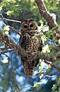 The Withington Wilderness contains critical habitat for the threatened Mexican spotted owl.
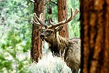 The Withington Wilderness is home to healthy populations of elk.
 A black bear in Cibola National Forest.
 A mule deer fawn in the snow.


