Nuntsi Provincial Park, also known as Taseko Provincial Park, is a provincial park in British Columbia, Canada, located on the west side of the Taseko River in that province's Chilcotin District, flanking both sides of Nuntsi Creek.
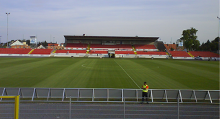
Tuja-Stadion is an 11,418 capacity stadium in Ingolstadt, Germany. It is primarily used for football and was the home of ESV Ingolstadt until they merged with MTV Ingolstadt to become FC Ingolstadt 04. It also hosted four football matches during the 1972 Summer Olympics. The stadium was modified in 2008 to suit 2nd division criteria. A new stadium is being planned and should be ready for the 2010/11 season.
Kłoda Górowska is a village in the administrative district of Gmina Góra, within Góra County, Lower Silesian Voivodeship, in south-western Poland. Prior to 1945 it was in Germany.

Ligota is a village in the administrative district of Gmina Góra, within Góra County, Lower Silesian Voivodeship, in south-western Poland. Prior to 1945 it was in Germany. It lies approximately 6 kilometres (4 mi) north-east of Góra and 71 km (44 mi) north-west of the regional capital Wrocław.
Łagiszyn is a village in the administrative district of Gmina Góra, within Góra County, Lower Silesian Voivodeship, in south-western Poland. Prior to 1945 it was in Germany.
Osetno is a village in the administrative district of Gmina Góra, within Góra County, Lower Silesian Voivodeship, in south-western Poland. Prior to 1945 it was in Germany. It lies approximately 8 kilometres (5 mi) south-west of Góra and 70 km (43 mi) north-west of the regional capital Wrocław.
Polanowo is a village in the administrative district of Gmina Góra, within Góra County, Lower Silesian Voivodeship, in south-western Poland. Prior to 1945 it was in Germany.
Sławęcice is a village in the administrative district of Gmina Góra, within Góra County, Lower Silesian Voivodeship, in south-western Poland. Prior to 1945 it was in Germany. It lies approximately 5 kilometres (3 mi) north-west of Góra and 74 km (46 mi) north-west of the regional capital Wrocław.
Strumienna is a village in the administrative district of Gmina Góra, within Góra County, Lower Silesian Voivodeship, in south-western Poland. Prior to 1945 it was in Germany.
Sułków is a village in the administrative district of Gmina Góra, within Góra County, Lower Silesian Voivodeship, in south-western Poland. Prior to 1945 it was in Germany.
Szedziec is a village in the administrative district of Gmina Góra, within Góra County, Lower Silesian Voivodeship, in south-western Poland. Prior to 1945 it was in Germany.
Wierzowice Małe is a village in the administrative district of Gmina Góra, within Góra County, Lower Silesian Voivodeship, in south-western Poland. Prior to 1945 it was in Germany.
Włodków Dolny is a village in the administrative district of Gmina Góra, within Góra County, Lower Silesian Voivodeship, in south-western Poland. Prior to 1945 it was in Germany.
Rudzienko-Kolonia is a village in the administrative district of Gmina Michów, within Lubartów County, Lublin Voivodeship, in eastern Poland.

Pustków Osiedle is a village in the administrative district of Gmina Dębica, within Dębica County, Subcarpathian Voivodeship, in south-eastern Poland. It lies approximately 10 kilometres (6 mi) north-east of Dębica and 37 km (23 mi) west of the regional capital Rzeszów. The housing estate – built in the 1930s – is nearly synonymous with the adjacent Pustków village. Total area of Pustków Osiedle – the smallest village in Gmina Dębica – is 150 hectares ; while the area of Pustków – the largest – is 2,285 hectares.
Paulin is a settlement in the administrative district of Gmina Warka, within Grójec County, Masovian Voivodeship, in east-central Poland.
Osiek is a village in the administrative district of Gmina Kościan, within Kościan County, Greater Poland Voivodeship, in west-central Poland. It lies approximately 11 kilometres (7 mi) south-east of Kościan and 45 km (28 mi) south of the regional capital Poznań.
Gorzupia is a village in the administrative district of Gmina Krotoszyn, within Krotoszyn County, Greater Poland Voivodeship, in west-central Poland. It lies approximately 6 kilometres (4 mi) east of Krotoszyn and 89 km (55 mi) south-east of the regional capital Poznań.
Ptaszkowo is a settlement in the administrative district of Gmina Nowogard, within Goleniów County, West Pomeranian Voivodeship, in north-western Poland.
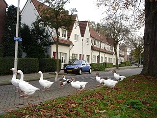
Vreewijk is a neighborhood of Rotterdam, Netherlands.


