
Chumphon is a southern Province (changwat) of Thailand on the Gulf of Thailand. Neighbouring provinces are Prachuap Khiri Khan, Surat Thani, and Ranong. To the west it borders the Burmese province of Tanintharyi.

Ballenstedt is a town in the Harz district, in the German state of Saxony-Anhalt.

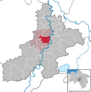
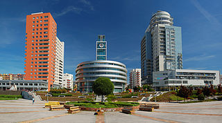
Bernburg (Saale) is a town in Saxony-Anhalt, Germany, capital of the Salzlandkreis district. The former residence of the Anhalt-Bernburg princes is known for its Renaissance castle.

Doilungdêqên District is a district in Lhasa, north-west of the main center of Chengguan, Tibet Autonomous Region. It is largely agricultural or pastoral, but contains the western suburbs of the city of Lhasa. The Duilong River runs southeast through the district to the Lhasa River. A prehistoric site appears to be 3600–3000 years old. The district is home to the Tsurphu Monastery (1189) and the 17th century Nechung monastery.

Alexisbad is a small spa town, part of Harzgerode in the district of Harz, Saxony-Anhalt, Germany.

Dhading District, a part of Bagmati Province, is one of the seventy-seven districts of Nepal. The district, with Dhading Besi as its district headquarters, covers an area of 1,926 square kilometres (744 sq mi), had a population of 338,658 in 2001 and 336,067 in 2011.

Olsberg is a town in the Hochsauerland district, in North Rhine-Westphalia, Germany.

Nienburg is a town in the district of Salzlandkreis in Saxony-Anhalt, Germany. It is located in the lower Saale valley, approx. 5 km northeast of Bernburg. In January 2010 it absorbed the former municipalities Gerbitz, Latdorf, Neugattersleben, Pobzig and Wedlitz, that became Ortschaften or municipal divisions of the town. In 2020 its population was 6,104.
Marklohe is a municipality in Lower Saxony, Germany.
Saraipali is a town in Mahasamund district in the Indian state of Chhattisgarh. First chief minister of Madhya Pradesh, Ravishankar Shukla was elected from here.
Stodůlky, Czech pronunciation: [ˈstoduːlkɪ], is a cadastral area in Prague, Czech Republic. Originally a village, later municipality, it remained a predominantly agricultural settlement until the 1960s. Stodůlky became part of Prague in 1974 and the large housing estate of Jihozápadní Město gradually arose on fields in vicinity of the old village in the late 1970s through mid-1990s. Nowadays Stodůlky covers an area of 9.63 square kilometres (3.72 sq mi) and has over 60 thousand inhabitants. Západní Město, a western extension of the built-up area is currently under construction.
Narail Sadar is an upazila of Narail District in the Division of Khulna, Bangladesh. Narail Thana was established in 1861 and was converted into an upazila in 1984. The upazila takes its name from the district and the Bengali word sadar (headquarters). It is the subdistrict where the district headquarters, Narail town, is located.

Poley is a village and a former municipality in the district of Salzlandkreis, in Saxony-Anhalt, Germany. Since 1 January 2010, it has been part of the town of Bernburg.

The Bundesstraße 71 is one of the longer German federal roads numbered in the 60s and 70s series. It begins at the B 6 in Bremerhaven by the Unterweser and ends in Könnern near Halle (Saale) in Saxony-Anhalt. To begin with it is one of the east-west links across the Elbe-Weser Triangle and runs in a gentle curve via Bremervörde and Zeven (71 km) over the Hansa Line A 1 (83 km) to the district town of Rotenburg (Wümme) (97 km). Here it crosses the B 75 and continues past the Lüneburg Heath to Soltau (133 km), where it crosses the B 3. Carrying on towards the east it runs through heathland to Uelzen (190 km), where the road again crosses another major federal route, the B 4. Next it runs through the Elbufer-Drawehn Nature Park and crosses the old Inner German Border and present-day state border between Lower Saxony and Saxony-Anhalt at kilometre marker 222.

Bundesstraße 209 (B 209) is a German federal road that runs from Nienburg/Weser district in Lower Saxony to Schwarzenbek in the district of Herzogtum Lauenburg, Schleswig-Holstein.

The Bundesstraße 214 is a federal road that runs from Lingen to Brunswick in North Germany.

The Bundesstraße 6n is a German federal road that runs east-west from the Vienenburg district of Goslar to Bernburg, where it connects to the A14. It was originally planned to be the A 36 motorway. It is intended to have four lanes running from the A 395 near Vienenburg through Wernigerode, Blankenburg, Quedlinburg, Aschersleben over the A 14 to Bernburg (Saale).

The Middle Weser Valley is part of the Weser Depression around the River Weser on the North German Plain, extending from the gap of Porta Westfalica to the town of Hoya. It is not a true valley, because it is only bordered by low hills at two points. It lies in the German federal states of Lower Saxony and North Rhine-Westphalia.

The Bundesstraße 23 is a German federal highway in Bavaria that runs about 59.2 kilometres, from Peiting to the Austrian border near Garmisch-Partenkirchen. This highway (partially), along with the Bundesstraße 17 and Bundesstraße 472 highways, constitute the “German Alpine Road”. Coupled with the Bundesstraße 2 highway, it passes through cities such as Mittenwald, Innsbruck and the Brenner Pass.
Laem Chabang is a port city municipality in Si Racha and Bang Lamung districts Chonburi Province, Thailand. It includes Thung Sukhla subdistrict (tambon) and parts of subdistricts Bueng, Nong Kham and Surasak of Si Racha District and part of Bang Lamung township of Bang Lamung District all of Chonburi province. As of 2019 it had a population of 88,271. The city has grown up around the port, but also serves as a major stop on the coastal highway linking Pattaya and Bangkok via Sukhumvit Road. The city is also known for hosting a Japanese retirement community with specialty stores geared towards them.


