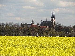
Bernburg

Last updated
Bernburg
Herbststimmung in Bernburg.jpg
Bernburg Castle on the Saale river
DE-ST 15-0-89-030 Bernburg COA.svg
Location of Bernburg within Salzlandkreis district
Bernburg (Saale) in SLK.pngBarbySeelandSeelandSeelandBorneSeelandSeelandSeelandNienburgBarby
Germany adm location map.svg
Red pog.svg
Bernburg
Saxony-Anhalt location map.svg
Red pog.svg
Bernburg
Coordinates: 51°48′N11°44′E / 51.800°N 11.733°E / 51.800; 11.733
Country Germany
State Saxony-Anhalt
District Salzlandkreis
Subdivisions7
Government
   Mayor (202128) Silvia Ristow [1] (Left)
Area
  Total113.45 km2 (43.80 sq mi)
Elevation
85 m (279 ft)
Population
 (2021-12-31) [2]
  Total32,000
  Density280/km2 (730/sq mi)
Time zone UTC+01:00 (CET)
  Summer (DST) UTC+02:00 (CEST)
Postal codes
06406
Dialling codes 03471, 034692
Vehicle registration SLK
Website www.bernburg.de

Bernburg (Saale) is a town in Saxony-Anhalt, Germany, capital of the Salzlandkreis district. The former residence of the Anhalt-Bernburg princes is known for its Renaissance castle.

Contents

Geography

The town centre is situated in the fertile Magdeburg Börde lowland on the Saale river, approx. 40 km (25 mi) downstream from Halle and 45 km (28 mi) up stream from Magdeburg. It is dominated by the huge Bernburg Castle featuring a museum as well as a popular, recently updated bear pit in its moat.

The municipal area comprises the town Bernburg proper and eight Ortschaften or municipal divisions: Aderstedt (incorporated in 2003), Baalberge, Biendorf, Gröna, Peißen, Poley, Preußlitz, and Wohlsdorf, all incorporated on 1 January 2010. [3] [4]

Bernburg is a stop on the scenic Romanesque Road (Strasse der Romanik).

Paleontology

Type fossil of temnospondyl amphibian Trematosaurus brauni was found in the Late Olenekian (Lower Triassic) deposits of Merkel's Quarry, near Bernburg. [5]

History

Several archaeological sites in the area refer to the Walternienburg-Bernburg Culture, a mid-neolithic funnelbeaker culture from about 3200 to 2800 BC. Agriculture on the fertile Loess soil was already common in prehistoric times. Around 150 AD, a local settlement named Luppia was mentioned in the Geography by Ptolemy. In the Early Middle Ages, the Saale river marked the border between the German stem duchies in the west and the lands of the Polabian Slavs in the east.

The present-day borough of Waldau (which became part of Bernburg in 1871) was first mentioned in a 782 deed and again in 806 as Waladala in the chronicles of Moissac Abbey; the village church dedicated to St Stephen first appeared in 964, the nowadays building dates from around 1150. Bernburg itself was first mentioned as civitas Brandanburg in a 961 deed issued by King Otto I of Germany. According to the Annalista Saxo, Berneburch Castle, then a possession of the Ascanian prince Albert the Bear, was set on fire by his enemies in 1138. In 1252 the rebuilt castle became the residence of Albert's great-grandson Prince Bernhard I of Anhalt-Bernburg.

Bernburg memorial

In the Nazi era during World War II, a wing of the town's mental hospital was used for the so-called T-4 Euthanasia Programme. The site today houses a memorial to commemorate the suffering of more than 14,000 victims.

Twin towns – sister cities

Bernburg is twinned with: [6]

Notable people

Honorary citizen

Date of award

All appointments of honorary citizens and the like from 1933 to 1945 were annulled. [7]

Sons and daughters of the city

Hilde Benjamin Fotothek df pk 0000213 012.jpg
Hilde Benjamin

People who have worked on the ground

Hermann Hellriegel Hermann Hellriegel.jpg
Hermann Hellriegel

See also

Related Research Articles

<span class="mw-page-title-main">Köthen</span> Town in Saxony-Anhalt, Germany

Köthen ( ) is a town in Germany. It is the capital of the district of Anhalt-Bitterfeld in Saxony-Anhalt, about 30 km (19 mi) north of Halle.

<span class="mw-page-title-main">Aken (Elbe)</span> Town in Saxony-Anhalt, Germany

Aken (Elbe) (German pronunciation:[ˈaːkən] ) is a town in the district of Anhalt-Bitterfeld in Saxony-Anhalt, Germany. The town is located at the left bank of the river Elbe.

<span class="mw-page-title-main">Ballenstedt</span> Town in Saxony-Anhalt, Germany

Ballenstedt is a town in the Harz district, which is a district in the German state of Saxony-Anhalt.

<span class="mw-page-title-main">Harzgerode</span> Town in Saxony-Anhalt, Germany

Harzgerode is a town in the district of Harz in Saxony-Anhalt, Germany.

<span class="mw-page-title-main">Burg bei Magdeburg</span> Town in Saxony-Anhalt, Germany

Burg is a town of about 22,400 inhabitants on the Elbe–Havel Canal in northeastern Germany, 25 km (16 mi) northeast of Magdeburg. It is the capital of the Jerichower Land district in the state of Saxony-Anhalt.

<span class="mw-page-title-main">Weißenfels</span> Town in Saxony-Anhalt, Germany

Weißenfels is the largest town of the Burgenlandkreis district, in southern Saxony-Anhalt, central Germany. It is situated on the river Saale, approximately 30 km (20 mi) south of Halle.

<span class="mw-page-title-main">Wolmirstedt</span> Town in Börde district, Saxony-Anhalt, Germany

Wolmirstedt is a town in the Börde district in Saxony-Anhalt, Germany. It is located 14 km north of Magdeburg, on the river Ohre. The town Wolmirstedt consists of Wolmirstedt proper and the Ortschaften Elbeu, Farsleben, Glindenberg and Mose.

<span class="mw-page-title-main">Haldensleben</span> Town in Saxony-Anhalt, Germany

Haldensleben is a town in Saxony-Anhalt, Germany. It is the administrative seat of the Börde district.

<span class="mw-page-title-main">Calbe</span> Town in Saxony-Anhalt, Germany

Calbe is a town in the district of Salzlandkreis, in Saxony-Anhalt, Germany.

<span class="mw-page-title-main">Nienburg, Saxony-Anhalt</span> Town in Saxony-Anhalt, Germany

Nienburg is a town in the district of Salzlandkreis in Saxony-Anhalt, Germany. It is located in the lower Saale valley, approx. 5 km northeast of Bernburg. In January 2010 it absorbed the former municipalities Gerbitz, Latdorf, Neugattersleben, Pobzig and Wedlitz, that became Ortschaften or municipal divisions of the town. In 2020 its population was 6,104.

<span class="mw-page-title-main">Egeln</span> Town in Saxony-Anhalt, Germany

Egeln is a small town in the Salzlandkreis district, in Saxony-Anhalt, Germany. It is the administrative seat of the Verbandsgemeinde Egelner Mulde.
<span class="mw-page-title-main">Könnern</span> Town in Saxony-Anhalt, Germany

is a town in the district of Salzlandkreis, in Saxony-Anhalt, Germany. It is situated on the right bank of the river Saale, approx. 15 km south of Bernburg, and 25 km northwest of Halle (Saale).

<span class="mw-page-title-main">Alsleben</span> Town in Saxony-Anhalt, Germany

Alsleben is a town in the district of Salzlandkreis, in Saxony-Anhalt, Germany. It is situated on the river Saale, south of Bernburg. It is part of the Verbandsgemeinde Saale-Wipper.

<span class="mw-page-title-main">Güsten</span> Town in Saxony-Anhalt, Germany

Güsten is a town in the district of Salzlandkreis, in Saxony-Anhalt, Germany. It is situated on the river Wipper, west of Bernburg. It is part of the Verbandsgemeinde Saale-Wipper. It absorbed the former municipality Amesdorf in January 2010.

<span class="mw-page-title-main">Genthin</span> Town in Saxony-Anhalt, Germany

Genthin is a town in Jerichower Land district, in Saxony-Anhalt, Germany.

<span class="mw-page-title-main">Möckern</span> Town in Saxony-Anhalt, Germany

Möckern is a town in the Jerichower Land district, in Saxony-Anhalt, Germany. It is situated east of Magdeburg. The Battle of Möckern took place south of the town in 1813.

<span class="mw-page-title-main">Mansfeld</span> Town in Saxony-Anhalt, Germany

Mansfeld, sometimes also unofficially Mansfeld-Lutherstadt, is a town in the district of Mansfeld-Südharz, in Saxony-Anhalt, Germany.

<span class="mw-page-title-main">Allstedt</span> Town in Saxony-Anhalt, Germany

Allstedt is a town in the district of Mansfeld-Südharz, in Saxony-Anhalt, Germany. It is situated approximatively 10 km southeast of Sangerhausen.

<span class="mw-page-title-main">Barby, Germany</span> Town in Saxony-Anhalt, Germany

Barby is a town in the Salzlandkreis district, in Saxony-Anhalt, Germany. It is situated on the left bank of the River Elbe, near the confluence with the Saale, approx. 25 km (16 mi) southeast of Magdeburg. Since an administrative reform of 1 January 2010 it comprises the former municipalities of the Verwaltungsgemeinschaft Elbe-Saale, except for Gnadau, that joined Barby in September 2010. The Barby Ferry, a reaction ferry across the Elbe, links Barby with Zerbst-Walternienburg.

Salzland is a district in the middle of Saxony-Anhalt, Germany. Its area is 1,428.1 km2 (551.4 sq mi). It is bounded by the districts Harz, Börde, Magdeburg, Jerichower Land, Anhalt-Bitterfeld, Mansfeld-Südharz and Saalekreis.

References

  1. Bürgermeisterwahlen in den Gemeinden, Endgültige Ergebnisse, Statistisches Landesamt Sachsen-Anhalt, accessed 3 February 2022.
  2. "Bevölkerung der Gemeinden – Stand: 31. Dezember 2021" (PDF) (in German). Statistisches Landesamt Sachsen-Anhalt. June 2022.
  3. Hauptsatzung der Stadt Bernburg (Saale) Archived 2022-01-21 at the Wayback Machine , December 2018.
  4. Gebietsänderungen vom 01. Januar bis 31. Dezember 2010, Statistisches Bundesamt
  5. Schoch, Rainer R. (2019-05-24). "Osteology of the temnospondyl Trematosaurus brauni Burmeister, 1849 from the Middle Buntsandstein of Bernburg, Germany". Palaeodiversity. 12 (1): 41. doi: 10.18476/pale.v12.a4 . ISSN   1867-6294.
  6. "Stadtporträt". bernburg.de (in German). Bernburg (Saale). Retrieved 2021-02-08.
  7. Beschluss der Magistratssitzung der Stadt Bernburg vom 26. März 1946 – Stadtarchiv Bernburg Findbuch 8/II-675