Wolfsberg (Calenberg Land)

Last updated
Wolfsberg

Wolfsberg-Luedersen.JPG

View looking west to the Wolfsberg near Lüdersen
Highest point
Elevation 152.1 m above  sea level (NN) (499 ft)
Prominence 11 m
Isolation 0.45 km  Süllberg
Coordinates 52°15′28″N9°39′55″E / 52.257639°N 9.66528°E / 52.257639; 9.66528 Coordinates: 52°15′28″N9°39′55″E / 52.257639°N 9.66528°E / 52.257639; 9.66528
Geography
Parent range Calenberg Land

The Wolfsberg is a spur of the Süllberg, 152.1 m above  sea level (NN) , in the Calenberg Land near Springe in the Hanover Region.

Süllberg (Calenberg Land) mountain

The Süllberg is a ridge, up to 198.2 m above sea level (NN), in the Calenberg Land near Springe in Hanover Region in the German state of Lower Saxony.

Normalnull

Normalnull or Normal-Null is an outdated official vertical datum used in Germany. Elevations using this reference system were to be marked "Meter über Normal-Null". Normalnull has been replaced by Normalhöhennull.

Calenberg Land geographic region

The Calenberg Land is a historic landscape southwest of Hanover in Germany, roughly formed by the countryside between the Leine and the Deister hills. The name of this region comes from the Principality of Calenberg ruled the area during the Middle Ages with its seat at Calenberg Castle near Pattensen.

Contents

Location

The Wolfsberg lies just under 1 kilometre north-northeast of the Süllberg which lies east of the Deister ridge in Germany's Central Uplands. It rises around 13 kilometres south-southwest of the centre of Hanover in the borough of Springe and municipality of Wennigsen, whose boundary runs over the northwestern flank of the hill. The village of Lüdersen which belongs to Springe lies on the Wolfsberg, the parish to the west belongs to Holtensen.

Deister mountain range

The Deister is a chain of hills in the German state of Lower Saxony, about 15 mi (25 km) southwest of the city of Hanover. It runs in a north-westerly direction from Springe in the south to Rodenberg in the north. The next in the chain of hills to the south is the Kleiner Deister from which it is separated by the flat pass of the Deister Gate. It is surrounded by Springe, Wennigsen, Barsinghausen, Bad Nenndorf, Rodenberg and Bad Münder.

Central Uplands

The Central Uplands is one of the three major natural regions of Germany and covers most of the land area of the country. To the north lies the North German Plain or Northern Lowland; to the south, the Alps and the Alpine Foreland.

Hanover Place in Lower Saxony, Germany

Hanover or Hannover is the capital and largest city of the German state of Lower Saxony. Its 535,061 (2017) inhabitants make it the thirteenth-largest city of Germany, as well as the third-largest city of Northern Germany after Hamburg and Bremen. The city lies at the confluence of the River Leine and its tributary Ihme, in the south of the North German Plain, and is the largest city of the Hannover–Braunschweig–Göttingen–Wolfsburg Metropolitan Region. It is the fifth-largest city in the Low German dialect area after Hamburg, Dortmund, Essen, and Bremen.

Geology and conservation

Wolfsberg spring Wolfsbergquelle Linderte IMG 3020.jpg
Wolfsberg spring

The Wolfsberg was formed in the Jurassic period. On its eastern side there are sandstone quarries with beds of Deister sandstone, which were exhausted in the 19th century. Since 1968 the Wolfsberg has been on the far side of the limit of building for protected area H-22 in the Hanover Region (this is currently being reviewed. According to political decisions the Wolfsberg element of LSG H-23 is to become part of North Deister). The reason for conservation is based on being the "central part of the natural space known as the Calenberg Loess Börde (Calenberger Lößbörde). This natural space is characterised by a layer of loess, up to 3 metres thick, that was formed in the Late and Post-Ice Age by wind excavation and deposition at the foot of the Central Uplands." [1] On the northern slope of the hill is the Wolfsberg Spring which has been enclosed for tourist reasons. From there rises a subordinate tributary stream of the Ihme, which flows not far from Linderte and Vörie.

The Jurassic period was a geologic period and system that spanned 56 million years from the end of the Triassic Period 201.3 million years ago (Mya) to the beginning of the Cretaceous Period 145 Mya. The Jurassic constitutes the middle period of the Mesozoic Era, also known as the Age of Reptiles. The start of the period was marked by the major Triassic–Jurassic extinction event. Two other extinction events occurred during the period: the Pliensbachian-Toarcian extinction in the Early Jurassic, and the Tithonian event at the end; however, neither event ranks among the "Big Five" mass extinctions.

Sandstone A clastic sedimentary rock composed mostly of sand-sized particles

Sandstone is a clastic sedimentary rock composed mainly of sand-sized mineral particles or rock fragments.

Hanover Region is a district in Lower Saxony, Germany. It is bounded by the districts of Heidekreis, Celle, Gifhorn, Peine, Hildesheim, Hamelin-Pyrmont, Schaumburg and Nienburg.

Settlement

On the eastern edge of the Wolfsberg is the deserted village of Weningrodere. This was abandoned in the phase of the Late Middle Ages when villages emptied out. It was last mentioned in the records in 1370. The village lay where the road from Holtensen to Lüdersen met the road from Lüdersen to Linderte. [2] Today the western side of the Wolfsberg is built upon. On the higher slopes of the domed summit, on which there is a residential quarter of Lüdersen, are residential roads.

Late Middle Ages Period of European history between 1250 and 1500 CE

The Late Middle Ages or Late Medieval Period was the period of European history lasting from 1250 to 1500 AD. The Late Middle Ages followed the High Middle Ages and preceded the onset of the early modern period.

Related Research Articles

Principality of Calenberg principality

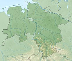
The Principality of Calenberg was a dynastic division of the Welf duchy of Brunswick-Lüneburg established in 1432. Calenberg was ruled by the House of Hanover from 1635 onwards; the princes received the ninth electoral dignity of the Holy Roman Empire in 1692. Their territory became the nucleus of the Electorate of Hanover, ruled in personal union with the Kingdom of Great Britain from 1714 onwards. The principality received its name from Calenberg Castle, a residence of the Brunswick dukes.

Barsinghausen Place in Lower Saxony, Germany

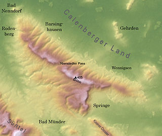
Barsinghausen is a town in the district of Hanover, in Lower Saxony, Germany. It is situated at the Deister chain of hills approx. 20 km west of Hanover. Barsinghausen belongs to the historic landscape Calenberg Land and was first mentioned in 1193.

Springe Place in Lower Saxony, Germany

Springe is a town in the district of Hanover, in Lower Saxony, Germany. It is situated near the Deister hills, 22 kilometres (14 mi) southwest of Hanover.

The Hildesheim Börde is a natural region, 272 km2 in area, in the northern part of Hildesheim district, which is known for its especially rich black earth loess soil.

Nesselberg mountains in Germany

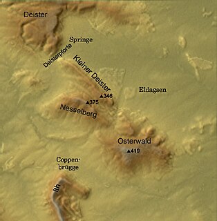
The Nesselberg is a ridge up to 378.2 m above sea level (NN) high in the Calenberg Highland which, together with the Kleiner Deister and the Osterwald, forms a group of three contiguous hill regions in the northwestern part of the Leine Uplands. It lies between Altenhagen I and Coppenbrügge in Lower Saxony, Germany.

Kleiner Deister mountains in Germany

The Kleiner Deister is a ridge of hills in the Calenberg Uplands which, together with the Nesselberg and the Osterwald, forms a group of three adjacent hill ranges in the northern part of the Leine Uplands. It lies between Springe and Eldagsen in Hanover region in Lower Saxony, Germany.

Weser Uplands-Schaumburg-Hamelin Nature Park nature park in Lower Saxony, Germany

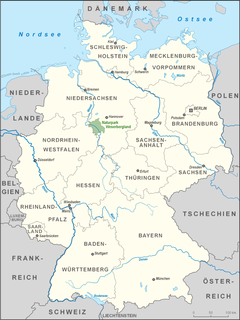
The Weser Uplands-Schaumburg-Hamelin Nature Park lies on the northern edge of the German Central Uplands where it transitions to the North German Plain, about 50 kilometres (31 mi) southwest of Hanover. The sponsor of the nature park, which was founded in 1975, is the state of Lower Saxony. The park extends along the Weser valley between Rinteln and Hamelin and includes parts of the Schaumburg Land, Calenberg, Lippe and Pyrmont Uplands from Bad Nenndorf in the north to Bad Pyrmont in the south, Bückeburg and Bad Eilsen in the west and Bad Münder and Osterwald in the east. Its highest elevation is in the Süntel hills.

Calenberg Castle castle

Calenberg Castle was a medieval lowland castle in central Germany, near Schulenburg in the borough of Pattensen, 13 km west of the city of Hildesheim. It was built as a water castle in 1292 by the Welf duke, Otto the Strict, in der Leine river meadows between 2 branches of the Leine river on the southern part of the chalk marl hill of the Calenberg. At the start of the 16th century it was converted into a fort (Feste). In the 15th century, Fort Calenberg gave its name to the Welf Principality of Calenberg. Following the Thirty Years' War it lost its military importance and was slighted. Today it is a ruin with underground vaults that are surrounded by high ramparts.

Deister-Süntel valley valley in Lower Saxony, Germany

The Deister-Süntel valley lies in the northeast Weser Uplands in the north German state of Lower Saxony between the ridges of the Bückeberg, Süntel and Deister in the districts of Schaumburg and Hameln-Pyrmont.

The Hanover–Altenbeken railway is a two-track electrified main line in the German states of Lower Saxony and North Rhine-Westphalia. It is now a part of the Hanover S-Bahn network.

The Deister Railway is a railway line in the German state of Lower Saxony between Weetzen and Haste. It is now a section of the Hanover S-Bahn network.

Osterwald (hills) mountain range

The Osterwald is a ridge in the Calenberg Uplands and together with the Nesselberg and the Kleiner Deister forms a unified group of three adjacent ranges in the Leine Uplands. It lies between Coppenbrügge, Eldagsen and Elze in the North German state of Lower Saxony.

Bröhn mountain

The Bröhn, is the highest hill in the Deister range in the German state of Lower Saxony. It owes its name to the broom growing here. The highest point of the hill is close to the Anna Tower, an observation tower on the territory of the town of Springe close to the boundary of the municipality of Wennigsen.

Benther Berg Ridge

The Benther Berg is a ridge, up to 173.3 m above sea level (NN), in the Calenberg Land near Benthe in Hanover Region in the German state of Lower Saxony.

<i>Börde</i>

A börde is a region of highly fertile lowland in North Germany, a "fertile plain". These landscapes often cover great areas and are particularly important for arable farming on account of their rich soils.

Deister Gate

The Deister Gate is a 550-metre-wide gap between the Deister and Kleiner Deister hill ridges in Springe in Hanover Region, Lower Saxony, Germany. The height of the pass varies between 130 m above NN to 120 m above NN. The River Haller rises in the Deister Gate. Several transport and supply routes run through the Deister Gate.

References

  1. http://www.hannover.de/data/download/RH/LSG/LSG-VO-H-22.pdf LSG-VO retrieved 2 November 2011
  2. Carl-Hans Hauptmeyer: Holtensen. Gemeinde Wennigsen. Dorfgeschichte als Beitrag zur Ortserneuerung. Hrsg. vom Heimatbund Niedersachsen. Hanover, 1982. ISBN   3-9800677-0-X S. 54