Passau is a Landkreis (district) in the southeast of Bavaria. It encloses the city of Passau geographically from two sides. Neighboring districts are Rottal-Inn, Deggendorf, Freyung-Grafenau. To the south it borders Austria.

The Bavarian Forest is a wooded, low-mountain region in Bavaria, Germany that is about 100 kilometres long. It runs along the Czech border and is continued on the Czech side by the Bohemian Forest. Most of the Bavarian Forest lies within the province of Lower Bavaria, but the northern part lies within Upper Palatinate. In the south it reaches the border with Upper Austria.
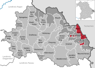
Freyung-Grafenau is a Landkreis (district) in Bavaria, Germany. It is bounded by the districts of Passau, Deggendorf and Regen, the Czech Republic and by Austria.

The Diocese of Passau is a Roman Catholic diocese in Germany that is a suffragan of the Archdiocese of Munich and Freising. Though similar in name to the Prince-Bishopric of Passau—an ecclesiastical principality that existed for centuries until it was secularized in 1803—the two are entirely different entities. The diocese covers an area of 5,442 km².

The Innviertel is a traditional Austrian region southeast of the Inn river. It forms the western part of the state of Upper Austria and borders the German state of Bavaria. The Innviertel is one of the four traditional "quarters" of Upper Austria, the others being Hausruckviertel, Mühlviertel, and Traunviertel.

Vimperk is a town in Prachatice District in the South Bohemian Region of the Czech Republic. It has about 7,400 inhabitants. The town centre is well preserved and is protected by law as an urban monument zone.
Burghausen is the largest town in the Altötting district of Upper Bavaria in Germany. It is situated on the Salzach river, near the border with Austria. Burghausen Castle rests along a ridgeline, and is the longest castle in the world.

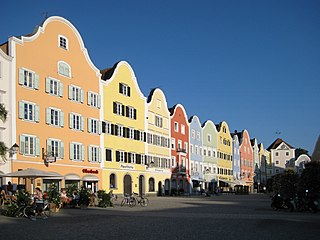
Waldkirchen is the biggest town in the district of Freyung-Grafenau in Germany.

Freyung is a town in Bavaria, Germany, capital of the Freyung-Grafenau district. It is situated in the Bavarian Forest mountain range, near the border with Austria and the Czech Republic.
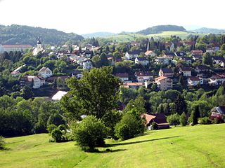
Grafenau is a town in the Freyung-Grafenau district, in Bavaria, Germany. 32 km north of Passau, the town is situated in the Bavarian Forest and is the base of the Bavarian Forest National Park Authority. Grafenau is a holiday destination with a variety of kinds of accommodation from self-catering apartments to a "holiday village".
Schärding is a town in northern Austrian state of Upper Austria, the capital of the district of the same name, and a major port on the Inn River. Historically, it was owned by the Wittelsbach family, which reflects in the town's architecture.
Haidmühle is a municipality in the district of Freyung-Grafenau in Bavaria in Germany.

Philippsreut is a municipality in the district of Freyung-Grafenau in Bavaria, Germany. It lies on the border with the Czech Republic.

Neuburg am Inn is a municipality in the district of Passau in Bavaria in Germany.

Olsbrücken is a municipality in the district of Kaiserslautern, in Rhineland-Palatinate, western Germany.

Allerheiligen bei Wildon is a municipality in the district of Leibnitz in Styria, Austria. The name "Allerheiligen" translates to "All Saints" and derives from the local church. The addition "bei Wildon" means "near Wildon", thus differentiating the municipality from others of the same name.
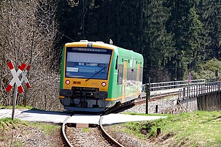
The building of the Zwiesel–Grafenau railway, today route number 906 in the timetable, was begun in 1884 by the Royal Bavarian State Railways and taken into service on 1 September 1890. With a total length of 32 km it linked the towns of Zwiesel and Grafenau in the Bavarian Forest. At Zwiesel railway station it connects to the Bavarian Forest railway from Plattling to Bayerisch Eisenstein, built by the Bavarian Ostbahn and opened on 16 September 1877, as well as the line to Bodenmais opened on 3 September 1928.
The Deggendorf–Kalteneck railway linked the railway line running through the Bavarian Forest from Plattling via Zwiesel to Bayerisch Eisenstein with the Ilz Valley railway (Ilztalbahn) from Passau via Waldkirchen to Freyung. In keeping with the naming of the Bavarian Forest railway or Waldbahn from Plattling to Bayerisch Eisenstein, it was called the Vorwaldbahn.

The Passau–Freyung railway, also known as the Ilz Valley Railway or Ilztalbahn, is a branch line in Bavaria, Germany. It runs from Passau to the town of Freyung in the Bavarian Forest. At Kalteneck it forms a junction with the branch line to Eging-Deggendorf. At Waldkirchen the Waldkirchen–Haidmühle line branches off towards the Czech border, where since 1945 there has been a junction with the Czech railway network.
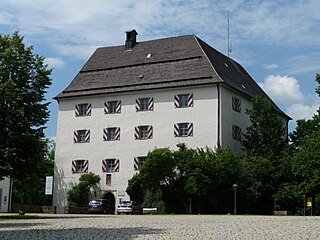
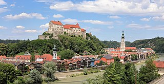
Wolfstein Castle or Schloss Wolfstein is a schloss and former castle in Freyung in Lower Bavaria. It gave its name to the county of Wolfstein which was dissolved in 1972.
This page is based on this
Wikipedia article Text is available under the
CC BY-SA 4.0 license; additional terms may apply.
Images, videos and audio are available under their respective licenses.


