The Arawak are a group of indigenous peoples of northern South America and of the Caribbean. Specifically, the term "Arawak" has been applied at various times to the Lokono of South America and the Taíno, who historically lived in the Greater Antilles and northern Lesser Antilles in the Caribbean. All these groups spoke related Arawakan languages.
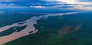
The Essequibo River is the largest river in Guyana, and the largest river between the Orinoco and Amazon. Rising in the Acarai Mountains near the Brazil–Guyana border, the Essequibo flows to the north for 1,014 kilometres (630 mi) through forest and savanna into the Atlantic Ocean. With a total drainage basin of 156,828 square kilometres (60,552 sq mi) and an average discharge of 4,531–5,650 cubic metres per second (160,000–199,500 cu ft/s).

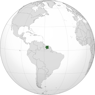
Nickerie is a district of Suriname, on the north-west coast. Nickerie's capital city is Nieuw-Nickerie. Another town is Wageningen. The district borders the Atlantic Ocean to the north, the Surinamese district of Coronie to the east, the Surinamese district of Sipaliwini to the south and Guyana to the west.

The Berbice River, located in eastern Guyana, is one of the country's major rivers. It rises in the highlands of the Rupununi region and flows northward for 595 kilometres (370 mi) through dense forests to the coastal plain. The river's tidal limit is between 160 and 320 km (99–199 mi) from the sea.

The Tiriyó are an Amerindian ethnic group native to parts of northern Brazil, Suriname, and Guyana. In 2014, there were approximately 3,640 Tiriyó in the three countries. They live in several major villages and a number of minor villages in the border zone between Brazil and Suriname. They speak the Tiriyó language, a member of the Cariban language family and refer to themselves as tarëno, etymologically 'people from here' or 'local people'.
Sipaliwini is a Tiriyó village on the Sipaliwini River in the Sipaliwini District of Suriname. The village lies next to the Sipaliwini Airstrip. The nearest village in Suriname is Alalapadu which is located 60 kilometres north on a map, but due to the twists and turns of the river, the town of Kwamalasamutu which lies 83 kilometres west is easier to reach. The Brazilian village of Missão can be reached by an unpaved path.

The Kalina, also known as the Caribs, mainland Caribs and several other names, are an indigenous people native to the northern coastal areas of South America. Today, the Kalina live largely in villages on the rivers and coasts of Venezuela, Guyana, Suriname, French Guiana, and Brazil. They speak a Cariban language known as Carib. They may be related to the Island Caribs of the Caribbean, though their languages are unrelated.
Kwamalasamutu, also Kwamalasamoetoe, is a Tiriyó Amerindian village in the Sipaliwini District of Suriname, and home to the granman of the northern Trios. Kwamalasamutu is the biggest village of the Tiriyó tribe.

Apoera, also Apura, is a town in western Suriname. The village has a population of 777 people as of 2020. It is the final destination of the Southern East-West Link. 24 kilometres (15 mi) north-west on the other side of the Courantyne River lies the Guyanese village of Orealla. The village is home to the Lokono tribe, but has been westernized. Due to the influx of people of Guyana, the languages used are English, and Sranan Tongo. Dutch is rarely spoken and the native language has all but disappeared. According to the oral tradition, Apoera was founded around 1920 by the Gordon family.

Coeroeni is a resort in Suriname, located in the Sipaliwini District. Its population at the 2012 census was 1,046. The resort is mainly inhabited by indigenous people of the Tiriyó tribe. Kwamalasamutu is the main village of the resort and home to the granman Asongo Alalaparu.
Paloemeu or Palumeu is a small Amerindian village in the interior of Suriname, situated at the site where the Paloemeu River joins the Tapanahoni River. Most inhabitants of the village are native Tiriyó Amerindians. The remainder belongs to Wayana, and the Aparai tribe. The Bosatlas in 1968 identified the village as Pepejoe which was incorrect according to the New West Indian Guide.

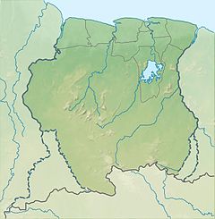
The borders of Suriname consist of land borders with three countries: Guyana, Brazil, and France. The borders with Guyana and France are in dispute, but the border with Brazil has been uncontroversial since 1906.

The Tigri Area is a wooded area that has been disputed since around 1840 by Guyana and Suriname. It involves the area between the Upper Corentyne River, the Coeroeni River and the Kutari River. This triangular area is in Guyana known as the New River Triangle. In 1969 the conflict ran high on and since then the Tigri Area is controlled by Guyana and claimed by Suriname. In 1971 both governments in Trinidad agreed that they continue talks over the border issue and withdraw their military forces from the disputed Triangle. Guyana has never held upon this agreement.
Werehpai is an archaeological site in Suriname consisting of several caves containing petroglyphs of pre-Columbian origin. The site is located about 10 kilometres (6.2 mi) from the village of Kwamalasamutu. With 313 identified petroglyphs, Werehpai is by far the largest pre-Columbian petroglyph site known in Suriname, and perhaps the largest in all of the Guianas.
Alalapadu is a Tiriyó village in the Sipaliwini District of Suriname. The village was founded by Baptist missionaries next to the Alalapadu Airstrip in order to concentrate the Tiriyó of the area in one central village.
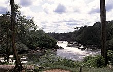
Amatopo or Amotopo is a Tiriyó village on the Courentyne River in the Sipaliwini District of Suriname. The village lies next to the Amatopo Airstrip and about 7 kilometres (4.3 mi) upstream from the village of Lucie. The Frederik Willem IV Falls and Arapahu Island are located near the village.
Wanapan or Arapahtë pata is a Tiriyó village in the Sipaliwini District of Suriname. It was established at the bottom of the Wonotobo Falls in 1998 by captain Arapahtë.
Squatting in Suriname is the occupation of unused land or derelict buildings without the permission of the owner. Maroons and indigenous peoples such as Tiriyó Amerindians have squatted buildings and illegal gold prospectors have occupied land.
Nappi is an indigenous village of Macushi Amerindians in the Upper Takutu-Upper Essequibo Region of Guyana. It is located in the Rupununi savannah along the Nappi and Maipaima creeks on the edge of the Kanuku Mountains.