Related Research Articles

Dorking is a market town in Surrey in South East England, about 21 mi (34 km) south of London. It is in Mole Valley District and the council headquarters are to the east of the centre. The High Street runs roughly east–west, parallel to the Pipp Brook and along the northern face of an outcrop of Lower Greensand. The town is surrounded on three sides by the Surrey Hills Area of Outstanding Natural Beauty and is close to Box Hill and Leith Hill.
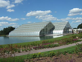
Wisley is a village and civil parish in Surrey, England between Cobham and Woking, in the Borough of Guildford. It is the home of the Royal Horticultural Society's Wisley Garden. The River Wey runs through the village and Ockham and Wisley Commons form a large proportion of the parish on a high acid heathland, which is a rare soil type providing for its own types of habitat. It has a standard weather monitoring station, which has recorded some national record high temperatures.

Mole Valley is a local government district in Surrey, England. Its council is based in Dorking, and the district's other town is Leatherhead. The largest villages are Ashtead, Fetcham and Great Bookham, in the northern third of the district.

Tandridge is a local government district in east Surrey, England. Its council is based in Oxted, although the largest settlement is Caterham; other notable settlements include Warlingham, Godstone and Lingfield. In mid-2019, the district had an estimated population of 88,129.

The village of Merrow in Surrey, England, is a suburb in the north-east of Guildford. It is 2 miles (3.2 km) from the town's centre, on the edge of the ridge of hills that forms the North Downs. Although now a relatively obscure suburb, the village can trace its origins back many hundreds of years. According to the Institute for Name-Studies, Merrow means 'fat', literally, "probably referring to the high fertility of the land".

Westcott is a village in central Surrey, England, about 1.5 miles (2.5 km) west of the centre of Dorking. It is in the Mole Valley district and the Surrey Hills Area of Outstanding Natural Beauty. The Pipp Brook, a tributary of the River Mole, runs to the north of the centre and the settlement is between Ranmore Common on the North Downs and Leith Hill on the Greensand Ridge.

Newdigate is a village and civil parish in the Mole Valley borough of Surrey lying in a relatively flat part of the Weald to the east of the A24 road between Dorking and Horsham, 13 miles (21 km) ESE of Guildford and 25 miles (40 km) south of London. Neighbouring parishes are Charlwood, North Holmwood, South Holmwood, Leigh and Capel.

Betchworth is a village and civil parish in the Mole Valley district of Surrey, England. The village centre is on the north bank of the River Mole and south of the A25 road, almost 3 miles (4.8 km) east of Dorking and 3 miles (4.8 km) west of Reigate. London is 19.5 miles (31.4 km) north of the village.
Westhumble is a village in south east England, approximately 2 km (1.2 mi) north of Dorking, Surrey. The village is not part of a civil parish, however the majority of the settlement is in the ecclesiastical Parish of Mickleham.

Ranmore Common, also known as Ranmore Commons, is an area of wooded former common land on the North Downs, immediately northwest of Dorking in the English county of Surrey. Its civil parish is Wotton, a geographically large village with a small population west of Dorking. Ranmore Common is within the Surrey Hills Area of Outstanding Natural Beauty, and part of it is Ranmore Common SSSI, a Site of Special Scientific Interest.

Wotton is a well-wooded parish with one main settlement, a small village mostly south of the A25 between Guildford in the west and Dorking in the east. The nearest village with a small number of shops is Westcott. Wotton lies in a narrow valley, collecting the headwaters of the Tilling Bourne which then has its first combined flow in the Vale of Holmesdale. The parish is long north to south, reaching to the North Downs escarpment in the north to the escarpment of the Greensand Ridge at Leith Hill in the south.

West Surrey was a parliamentary constituency in the county of Surrey, which returned two Members of Parliament (MPs) to the House of Commons of the Parliament of the United Kingdom, elected by the bloc vote system.
Copthorne was a hundred of Surrey, England, an area above the level of the parishes and manors, where the local wise, wealthy and powerful met periodically in Anglo-Saxon England for strategic purposes. After the Norman Conquest the lords of the manor took to annual hundred meetings and their status became eroded by royal-approved transactions of land, as meanwhile the manorial courts and moreover royal courts seized jurisdiction over the Hundred Courts.
Effingham Hundred or the Hundred of Effingham was a hundred but often treated as a half-hundred with that of Copthorne and was the smallest in Surrey, England.

Woking was a hundred in what is now Surrey, England. It includes the town of Woking and the Borough of Woking.
Cuddington was a village in Surrey which was demolished to make way for Henry VIII's Nonsuch Palace near Cheam. Cuddington lay within the Copthorne hundred. There remains a small rise of land to mark the northern side of the old Cuddington parish church.

Hackhurst and White Downs is a 185.1-hectare (457-acre) biological Site of Special Scientific Interest west of Dorking in Surrey. White Downs is a Nature Conservation Review site, Grade 2, and part of it is in the 200-hectare (490-acre) White Downs nature reserve, which is owned by the Wotton Estate and managed by the Surrey Wildlife Trust (SWT). Hackhurst Downs is a 29.9-hectare (74-acre) Local Nature Reserve, which part of the 40-hectare (99-acre) Hackhurst Downs nature reserve, which is owned by Surrey County Council and also managed by the SWT.
Blackheath Hundred or the Hundred of Blackheath was a hundred in the county of Surrey, England. It corresponds to parts of the districts of Waverley and Guildford.
The Pipp Brook is a left-bank tributary of the River Mole, Surrey, England. It rises at two main springs north of Leith Hill on the Greensand Ridge, then descends steeply in a northward direction, before flowing eastwards along the Vale of Holmesdale. It runs to the north of Dorking High Street, before discharging into the Mole at Pixham.

Wotton and Abinger Commons is a 324-hectare (800-acre) nature reserve south-west of Dorking in Surrey. It is managed by the Surrey Wildlife Trust. Part of it is in Leith Hill Site of Special Scientific Interest
References
- 1 2 3 H.E. Malden, ed. (1911). "The hundred of Wotton: Introduction and map". A History of the County of Surrey: Volume 3. Institute of Historical Research. Retrieved 22 January 2014.