Wrington Vale Light Railway

Last updated

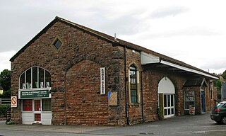
The railway in 1962 Wrington Railway - geograph.org.uk - 104593.jpg
The railway in 1962
Wrington Vale
Light Railway
BSicon exCONTg.svg
BSicon exdHST-L.svg
BSicon exdKHSTa-R.svg
Congresbury
BSicon exBS2c1.svg
BSicon exCONTf@F.svg
BSicon exBS2+r.svg
BSicon exHST.svg
Wrington
BSicon exHST.svg
Langford
BSicon exHST.svg
Burrington
BSicon exKHSTe.svg
Blagdon

The Wrington Vale Light Railway was a railway from Congresbury on the Cheddar Valley line to Blagdon, and serving villages in the Yeo Valley located in North Somerset, England. Construction of the line started in 1897 and it opened in 1901. Never more than a purely local line, it closed to passengers in 1931, and completely in 1963.

Contents

History

Construction

The first attempt to build a railway line in this part of North Somerset took place in 1882 when an Act was obtained (on 18 August) incorporating the Radstock, Wrington & Congresbury Junction Railway, which was to run from Farrington Gurney on the Bristol and North Somerset Railway to Congresbury through Wrington. However sufficient capital could not be raised, and the company was dissolved in 1886.

The Light Railways Act 1896 (59 & 60 Vict. c. 48) was passed to enable low-cost local railways to be built, and a line from Blagdon to Congresbury was promoted. At this time the Bristol Waterworks Company were building a reservoir at Blagdon, [note 1] and they supported the scheme. The Great Western Railway (GWR) agreed to finance the scheme and manage the actual construction.

In 1896, an application was made for a Light Railway Order; there was to be a short branch to Blagdon Waterworks. A statutory enquiry was held on 20 May 1897. [1]

A public inquiry was held on 20 May 1897; the line was supported by Bristol Waterworks Company. The Order was confirmed on 18 March 1898, and the Great Western Railway was authorised to finance, construct and work the line.

Lt Col Yorke inspected the line on 28 November 1901, and as he found it satisfactory, the line opened to traffic on 4 December 1901. It was 6 miles 41 chains (10.5 km) long and there were stations at Wrington, Langford, Burrington and Blagdon. [2] [3] [4]

Gradients were severe: leaving Blagdon the line fell at 1 in 75 and then rose at the same gradient, followed by a further downward gradient of 1 in 75. There was then a local summit at Burrington, falling from Langford at 1 in 50. From Wrington to Congresbury the line was broadly level, although with short sections rising at 1 in 70 and falling at 1 in 60. At Blagdon there was a spur siding diverging to the right on the approach, serving the Yeo Pumping Station. [1]

Traffic

The railway's primary purpose was to bring construction materials for the building of the Blagdon Lake reservoir. [5] Construction of the line overran cost and time forecasts. It was constructed and owned by the Great Western Railway. The GWR used it to trial various innovative schemes to reduce the cost of lightly used passenger services, such as the push-pull system, where driver's controls are provided in a trailer coach, enabling the locomotive to propel its train, eliminating the need for the engine to run round at the end of a run, and so cutting costs. The motor trolley system of maintenance was also adopted. The GWR 101 Class experimental oil-fired locomotive of 1901 was also designed for use on this line, but issues with the technology prevented it from coming into service.

Milk traffic was a considerable source of business on the line. [6]

Initially passenger trains generally ran from Yatton, the junction for the main line between Bristol and Exeter, and traversed 1.8 miles of the Cheddar Valley Line, that had opened in 1869.

The junction for the light railway was at Congresbury, where a second platform and much extended track and signalling were provided.

When the line first opened in 1901, there were four trips a day each way between Blagdon and Yatton; one trip each way was a mixed passenger and goods service. [6] The first train out of Blagdon in the morning went only as far as Congresbury, and returned to Blagdon from there. Other trains ran through from or to Yatton. In 1910, there were five trains a day in each direction on weekdays only. Until 1915, there was a late trip on Saturdays from Blagdon to Yatton and return.

With light loadings, the service was reduced to three trains a day each way in 1919, but the fourth trip was re-instated in 1921. Railmotors were considered at this time in an effort to match operating costs to income, but the gradients on the line prevented them from operating successfully so they were not used.

In 1926, the service was increased again to five trips a day, to respond to competition from the Bristol Tramways and Carriage Company's buses. However, this was not successful, and the service returned to the original four trips a day in 1927, until closure to passenger traffic from 14 September 1931. [1] [3] [7]

In 1926 also the General Strike took place. Nestlé were managing milk flows from the area at the time, and arranged road lorry collections for the milk traffic. When the strike ended, much of this business stayed on road. [1]

Freight service continued along the length of the line until 1 November 1950, when the section between Wrington and Blagdon was closed fully. Coal traffic continued to Wrington until 6 June 1963, and the line closed completely on 10 June 1963; Congresbury itself retained passenger services until later in 1963, when it closed with the rest of the Yatton to Witham line. [1] [2] [6]

Since closure

After trains were withdrawn the track was lifted and station buildings either demolished or left unoccupied. The only buildings on the line to have survived until the present day are at Blagdon station, which is now part of a private residence, and the stationmaster's house at Burrington, although it has been much extended.

The Strawberry Line Association and Sustrans have aspirations for a cycle route on the trackbed. North Somerset council has marked the former railway as a future key cycle route in the local plan. The cycle route would connect with the Strawberry Line railway walk at Congresbury and a future route to Clevedon at Yatton station. Much of the planned route between Blagdon and Wrington is in private ownership which presents an obstacle for the route as, apart from the technical issue of who owns which bit of land, there’s a shortage of public money to buy real estate. [8]

In 2016, the West of England Local Enterprise Partnership produced a report outlining the possibility of using the old trackbed of the railway for the proposed Bristol Airport Rail Link. [9]

Notes

  1. Parliamentary approval had been obtained in 1888 and work started in 1891; the reservoir started to fill in 1899 and was ready in 1903. Four compound beam engines were responsible for the pumping until April 1949 when they were replaced with electric pumps. Source= Maggs.

Related Research Articles

<span class="mw-page-title-main">Yatton</span> Human settlement in England

Yatton is a village and civil parish within the unitary authority of North Somerset, which falls within the ceremonial county of Somerset, England. It is located 11 miles (18 km) south-west of Bristol. Its population in 2011 was 7,552. The parish includes Claverham, a small village which was originally a farming hamlet.

<span class="mw-page-title-main">East Somerset Railway</span> Former railway company and heritage railway

The East Somerset Railway is a 1 mi 63 ch (2.9 km) heritage railway in Somerset, running between Cranmore and Mendip Vale. The railway was once part of the former Cheddar Valley line that ran from Witham to Yatton, meeting the Somerset and Dorset Joint Railway at Wells but was considered for closure even before the publication of 'The Reshaping of British Railways' by Dr Richard Beeching in March 1963.
<span class="mw-page-title-main">Congresbury</span> Human settlement in England

Congresbury is a village and civil parish on the northwestern slopes of the Mendip Hills in North Somerset, England, which in 2011 had a population of 3,497. It lies on the A370 between Junction 21 of the M5 and Bristol Airport, 13 miles (21 km) south of Bristol city centre, and 7 miles (11 km) east of Weston-super-Mare. The Congresbury Yeo river flows through the village. The parish includes the hamlet of Brinsea.

<span class="mw-page-title-main">Churchill, Somerset</span> Village and civil parish in Somerset, England

Churchill is a village and civil parish in the unitary authority of North Somerset, part of the ceremonial county of Somerset. It is located on the western edge of the Mendip Hills, about 8 miles (12.9 km) east of Weston-super-Mare, and about 15 miles (24.1 km) south-west of Bristol. The parish, which includes the village of Lower Langford and the hamlet of Upper Langford, has a population of 2,250.

<span class="mw-page-title-main">Blagdon Lake</span> Lake in the United Kingdom

Blagdon Lake lies in a valley at the northern edge of the Mendip Hills, close to the village of Blagdon and approximately 10 miles (16 km) south of Bristol, England. The lake was created by Bristol Water, when it dammed the River Yeo, starting construction in 1898, to designs by Charles Hawksley, and completing this in 1905. The Wrington Vale Light Railway was constructed primarily to bring building materials for the lake.

<span class="mw-page-title-main">Yatton railway station</span> Railway station near Bristol, England

Yatton railway station, on the Bristol to Exeter line, is in the village of Yatton in North Somerset, England. It is 12 miles (19 km) west of Bristol Temple Meads railway station, and 130 miles (209 km) from London Paddington. Its three-letter station code is YAT. It was opened in 1841 by the Bristol and Exeter Railway, and served as a junction station for trains to Clevedon and Cheddar, but these lines closed in the 1960s. The station, which has two platforms, is managed by Great Western Railway, the seventh company to be responsible for the station, and the third franchise since privatisation in 1997. They provide all train services at the station, mainly hourly services between Bristol Parkway and Weston-super-Mare, and between Cardiff Central and Taunton.

<span class="mw-page-title-main">Bristol and Exeter Railway</span> Former English railway company

The Bristol and Exeter Railway (B&ER) was an English railway company formed to connect Bristol and Exeter. It was built on the broad gauge and its engineer was Isambard Kingdom Brunel. It opened in stages between 1841 and 1844. It was allied with the Great Western Railway (GWR), which built its main line between London and Bristol, and in time formed part of a through route between London and Cornwall.
<span class="mw-page-title-main">Witham (Somerset) railway station</span> Railway station in Somerset, England

Witham (Somerset) railway station was a station serving the Somerset village of Witham Friary and was located on the Frome to Yeovil section of the Wilts, Somerset and Weymouth Railway that opened in 1856.

The Cheddar Valley line was a railway line in Somerset, England, running between Yatton and Witham. It was opened in parts: the first section connecting Shepton Mallet to Witham, later extended to Wells, was built by the East Somerset Railway from 1858. Later the Bristol and Exeter Railway built their branch line from Yatton to Wells, but the two lines were prevented for a time from joining up. Eventually the gap was closed, and the line became a simple through line, operated by the Great Western Railway.

<span class="mw-page-title-main">Wells (Priory Road) railway station</span> Former railway station in England

Wells (Priory Road) was a railway station on the Somerset and Dorset Joint Railway at Wells in the county of Somerset in England. Opening on 15 March 1859 as Wells, on the Somerset Central Railway, at that time a broad-gauge line operated by the Bristol and Exeter Railway, prior to that company's amalgamation with the Dorset Central Railway to form the Somerset & Dorset, it was the terminus of the branch from Glastonbury.

<span class="mw-page-title-main">Congresbury railway station</span> Former railway station in England

Congresbury railway station was a station located at Congresbury on the Bristol and Exeter Railway's Cheddar Valley line in Somerset and the junction for the Wrington Vale Light Railway to Blagdon.

<span class="mw-page-title-main">Winscombe railway station</span> Former railway station in Somerset, England

Winscombe railway station was a station on the Bristol and Exeter Railway's Cheddar Valley line in Winscombe, Somerset.

<span class="mw-page-title-main">Axbridge railway station</span> Disused railway station in Axbridge, Somerset

Axbridge railway station was a station on the Bristol and Exeter Railway's Cheddar Valley line in Axbridge, Somerset. Axbridge was one of the principal stations for the transport of strawberries, which led to the line's alternative name as The Strawberry Line.
<span class="mw-page-title-main">Cheddar railway station</span> Former railway station in England

Cheddar railway station was a station on the Bristol and Exeter Railway's Cheddar Valley line in Cheddar, Somerset, England. The station had substantial goods traffic based on the locally-grown strawberries, which led to the line's alternative name as The Strawberry Line.

Lodge Hill railway station was a station on the Bristol and Exeter Railway's Cheddar Valley line in Somerset, England from 1870 until 1963. The station served the village of Westbury-sub-Mendip, but was not named Westbury because of the potential for confusion with Westbury, Wiltshire.

<span class="mw-page-title-main">Wookey railway station</span> Former railway station in England

Wookey railway station was a station on the Bristol and Exeter Railway's Cheddar Valley line in Somerset, England. The site is a 0.04 hectare geological Site of Special Scientific Interest between Wells and Wookey Hole.
<span class="mw-page-title-main">Wells (Tucker Street) railway station</span> Former railway station in Wells, England, United Kingdom

Wells railway station was the second terminus station on the Bristol and Exeter Railway's Cheddar Valley line in Somerset after the extension from the first terminus at Cheddar was opened. It was the third station on the third railway to reach the city of Wells and proved to be the longest surviving.

<span class="mw-page-title-main">Transport in Somerset</span> Overview of transport in Somerset

The earliest known infrastructure for transport in Somerset is a series of wooden trackways laid across the Somerset Levels, an area of low-lying marshy ground. To the west of this district lies the Bristol Channel, while the other boundaries of the county of Somerset are along chains of hills that were once exploited for their mineral deposits. These natural features have all influenced the evolution of the transport network. Roads and railways either followed the hills, or needed causeways to cross the Levels. Harbours were developed, rivers improved, and linked to sources of traffic by canals. Railways were constructed throughout the area, influenced by the needs of the city of Bristol, which lies just to the north of Somerset, and to link the ports of the far south-west with the rest of England.

<span class="mw-page-title-main">Wrington railway station</span> Disused railway station in Wrington, North Somerset

Wrington railway station was a station at Wrington on the Wrington Vale Light Railway, which ran from Congresbury to Blagdon, in Somerset, England.

<span class="mw-page-title-main">Blagdon railway station</span> Disused railway station in Blagdon, North Somerset

Blagdon railway station is a closed terminus railway station situated in the village of Blagdon in North Somerset, England.

References

  1. 1 2 3 4 5 Colin G Maggs, Wrington Vale Light Railway, Oakwood Press, Usk, 2004, ISBN   978-0-85361-620-7
  2. 1 2 Derek Phillips, Steaming Through the Cheddar Valley, Oxford Publishing Co., Hersham, 2001, ISBN   0 86093 551 5
  3. 1 2 "Railway Magazine", November 1959
  4. E T MacDermot, History of the Great Western Railway, volume II, published by the Great Western Railway, London, 1932
  5. "History of Blagdon". Bristol Water. Retrieved 3 April 2009.
  6. 1 2 3 Yorke, Stan (2007). Lost railways of Somerset. Newbury: Countryside Books. pp. 78–82. ISBN   978-1-84674-057-2.
  7. "A Selection of Great Western Stations". The Great Western Archive. Retrieved 3 April 2009.
  8. Mottram, Harry. "Feature. How far can the Strawberry Line go?". Strawberry Line Times. Retrieved 11 April 2014.
  9. "Bristol South West Economic Link - Options Development Report" (PDF). westofenglandlep.co.uk. Retrieved 20 November 2016.

Sources