Wyoming Highway 220

Last updated

WY-220.svg

Wyoming Highway 220

Alcova Highway
Wyoming Highway 220
WYO 220 highlighted in red
Route information
Maintained by WYDOT, City of Casper
Length72.79 mi (117.14 km)
Existed1938–present
Major junctions
West endUS 287 square.svgWY-789.svg US 287  / WYO 789 at Muddy Gap Junction
East endI-25.svgUS 20.svgUS 26.svgUS 87.svg I-25  / US 20  / US 26  / US 87 in Casper
Location
Country United States
State Wyoming
Counties Carbon, Natrona
Highway system
  • Wyoming State Highway System
WY-219.svg WYO 219 WY-221.svg WYO 221
US 87.svg US 87 US 87E.svg US 89.svg US 89

Wyoming Highway 220 (WYO 220) is the principal highway connecting the city of Casper to US 287/WYO 789. WYO 220 lies in northwestern Carbon and southern Natrona counties and along the famous Oregon Trail.

Contents

Route description

I-25 southbound Exit 188B - WYO 220 in Casper, WY I-25SBExit188BWY.JPG
I-25 southbound Exit 188B - WYO 220 in Casper, WY
Wyoming Highway 220 near Martin's Cove Wyoming Highway 220 near Martin's Cove in Natrona County, Wyoming.jpg
Wyoming Highway 220 near Martin's Cove

Wyoming Highway 220 begins its western end in Carbon County at US 287/WYO 789 at Muddy Gap Junction and from there heads northeast toward Casper. Nearing 20 miles, Highway 220 leaves Carbon County and enters Natrona County as it nears the north side of the Pathfinder Reservoir and the Pathfinder National Wildlife Refuge. [1] It passes Independence Rock, a large granite rock with carvings from mid-19th century emigrants. [2]

WYO 220 passes north of the reservoir, now traveling more easterly as it comes upon the census-designated place (CDP) of Alcova, the center of population of Wyoming. Also to the south lies Alcova Lake. Past Alcova, WYO 220 turns back northeast and begins to parallel the North Platte River and continue until it reaches Casper. At 53.17 miles the northern terminus of Wyoming Highway 487 is intersected as 220 continues northeast. [1] Just before entering the Casper city limits, the two-lane highway becomes a divided multi-lane highway with two lanes for each direction of traffic, and becomes known as CY Avenue. Wyoming Highway 258 (Wyoming Boulevard) is intersected at just over 69 miles. Past WYO 258, the multi-lane division continues until just before the intersection of CY Avenue and Poplar Street. At this intersection, WYO 220 follows Poplar Street north. [1] As WYO 220 heads north on Poplar Avenue, US 20 Business/US 26 Business (First Street) is intersected within a mile and three-quarters of a mile later, WYO 220 reaches its eastern end at Interstate 25 (exit 188B), which also carries US 20/US 26/US 87 as well.

The highway is maintained by WYDOT, except for portions of CY Avenue and Poplar Street in Casper, which are maintained locally.

History

Between 1926 and 1938, what is now WYO 220 was part of U.S. Route 87E (US 87E).[ citation needed ] In 1938, US 87E's portion in Wyoming was redesignated as WYO 220. [3] The highway generally follows the path of the historic Oregon Trail and has several commemorative markers at various points. [2] WYO 220 originally terminated at US 20 and US 26 in downtown Casper and was later extended north along Center Street to I-25, which was completed in October 1960. [4]

A new "inner-city connector" between WYO 220 and I-29 via Poplar Street was proposed in the 1960s to redirect traffic from downtown. [5] The first phase of the project, a new bridge over the North Platte River and the Chicago, Burlington and Quincy Railroad, opened in late 1968. [6] The full extension of Poplar Street opened on August 14, 1984, following work to relocate a railyard and widening of the street south of the river. [7] WYO 220 was relocated onto the extension, while its old alignment along Center Street became Highway 255. [8]

A portion of the highway in "the Narrows" near Goose Egg was straightened and improved during a 1965 that cost $1.58 million to construct; the project also included preparations to widen the highway to four lanes. [9] Calls to widen WYO 225 grew in the late 1980s after a series of vehicle collisions that killed several people. [10] The state government began work on widening bridges and intersections along the section in 1988, but declined to widen the entire highway. [11]

A western bypass of Casper to relieve congestion on WYO 220 was proposed in the late 1990s and approved for construction in 2000. [12] The route, named Highway 257, opened in December 2015. [13]

Major intersections

CountyLocationmikmDestinationsNotes
Carbon Muddy Gap 0.0000.000US 287 square.svgWY-789.svg US 287  / WYO 789  / California National Historic Trail / Mormon Pioneer National Historic Trail / Oregon National Historic Trail / Pony Express National Historic Trail / Chief Washakie Trail Rawlins, Lander Western terminus; highway continues as US 287/WYO 789 south
Natrona 53.17085.569WY-487.svg WYO 487  Medicine Bow Northern terminus of WYO 487
63.915102.861WY-257.svgTo plate blue.svg
I-25.svg
To plate.svg
US 87.svg
To plate.svg
US 20.svg
To plate.svg
US 26.svg
WYO 257 (Casper West Belt) to I-25  / US 87  / US 20  / US 26  Sheridan, Cheyenne, Shoshoni
Southern terminus of WYO 257; opened in December 2015
Casper 69.260111.463WY-258.svg WYO 258 (Wyoming Boulevard)
72.120116.066Business plate.svg
US 20.svg
Business plate.svg
US 26.svg
US 20 Bus.  / US 26 Bus. (First Street)
72.790117.144I-25.svgUS 20.svgUS 26.svgUS 87.svg I-25  / US 20  / US 26  / US 87  / California National Historic Trail / Mormon Pioneer National Historic Trail / Oregon National Historic Trail / Pony Express National Historic Trail  Buffalo, Cheyenne, Airport Eastern terminus; exit 188B on I-25; road continues north as Poplar Street
1.000 mi = 1.609 km; 1.000 km = 0.621 mi

See also

Related Research Articles

<span class="mw-page-title-main">Casper, Wyoming</span> City in Wyoming, United States

Casper is a city in, and the county seat of, Natrona County, Wyoming, United States. Casper is the second-largest city in the state, with the population at 59,038 as of the 2020 census. Casper is nicknamed "The Oil City" and has a long history of oil boomtown and cowboy culture, dating back to the development of the nearby Salt Creek Oil Field.

<span class="mw-page-title-main">Wyoming Highway 34</span> State highway in Wyoming, United States

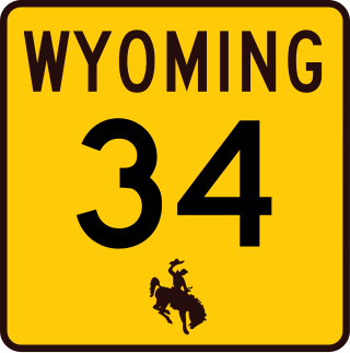
Wyoming Highway 34 (WYO 34) is a 52.38-mile-long (84.30 km) Wyoming state highway known as Laramie-Wheatland Road. Located in Albany and Platte counties, it spans from U.S. Routes 30 and 287 near Bosler to Interstate 25 / U.S. Route 87 in Wheatland.

<span class="mw-page-title-main">Interstate 25 in Wyoming</span> Section of Interstate Highway in Wyoming, United States

Interstate 25 (I-25) is a part of the Interstate Highway System that runs from Las Cruces, New Mexico, to Buffalo, Wyoming. In Wyoming, the Interstate Highway runs 300.530 miles (483.656 km) from the Colorado state line near Cheyenne north to its national terminus at I-90 near Buffalo. I-25 connects Wyoming's largest city and capital, Cheyenne, with its second largest city, Casper, and the smaller communities of Wheatland, Douglas, and Buffalo. The highway also connects those cities with Denver and Billings via I-90. I-25 runs concurrently with U.S. Route 87 (US 87) for almost its entire course in Wyoming. The highway also has extensive concurrencies with US 20 and US 26 along its east–west segment through the North Platte River valley. The Interstate has business loops through Cheyenne, Chugwater, Wheatland, Douglas, Glenrock, Casper, and Buffalo.

<span class="mw-page-title-main">Interstate 90 in Wyoming</span> Section of Interstate Highway in Wyoming, United States

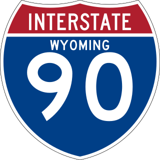
Interstate 90 (I-90) in the US state of Wyoming traverses the northeastern corner of the state, passing through the cities and communities of Sheridan, Buffalo, and Gillette.

<span class="mw-page-title-main">Wyoming Highway 258</span> State highway in Wyoming, United States

Wyoming Highway 258 is a 10.58-mile-long (17.03 km) state highway in Wyoming, known as Wyoming Boulevard and acts as a two-lane bypass around the western, southern, and eastern sides of the City of Casper.

<span class="mw-page-title-main">Wyoming Highway 487</span> Highway in Wyoming

Wyoming Highway 487 (WYO 487) is a 71.56-mile-long (115.16 km) state highway in northeastern Carbon County, Wyoming and southeastern Natrona County, Wyoming that runs from its south end at US 30/US 287 to a north end at WYO 220.

<span class="mw-page-title-main">Wyoming Highway 28</span> State highway in Wyoming, United States

Wyoming Highway 28 (WYO 28) is a 96.46-mile-long (155.24 km) Wyoming state highway known as the South Pass Highway. It travels from its split from Wyoming Highway 372 near the Seedskadee National Wildlife Refuge, across the high plains and over South Pass until its junction with U.S. Route 287 8 miles (13 km) south of Lander.

<span class="mw-page-title-main">Wyoming Highway 255</span> State highway in Wyoming, United States

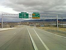
Wyoming Highway 255 (WYO 255) is a short 0.48-mile-long (0.77 km) unsigned Wyoming state road in the City of Casper known as N. Center Street. This route provides a connection between US 20 Business/US 26 Business and I-25/US 20/US 26/US 87 and runs concurrent with the I-25/US 87 Business route.

<span class="mw-page-title-main">Wyoming Highway 256</span> State highway in Wyoming, United States

Wyoming Highway 256 (WYO 256) is a 2.67-mile-long (4.30 km) state road in Evansville, Wyoming, just east of Casper known as Cole Creek Road.

<span class="mw-page-title-main">Wyoming Highway 253</span> State highway in Wyoming, United States

Wyoming Highway 253 (WYO 253) is a 10.90-mile-long (17.54 km) state road in eastern Natrona county located southeast of Evansville, Wyoming, called Hat Six Road.

<span class="mw-page-title-main">Wyoming Highway 254</span> Highway in Wyoming

Wyoming Highway 254 (WYO 254) is a 4.06-mile-long (6.53 km) state road northwest of Casper, Wyoming known as Salt Creek Highway.

<span class="mw-page-title-main">Wyoming Highway 259</span> State highway in Wyoming, United States

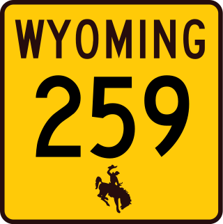
Wyoming Highway 259 (WYO 259) is an 18.00-mile-long (28.97 km) north-south state highway located in northeastern Natrona County, north of Casper, in the east-central part of the U.S. state of Wyoming. The highway is the former routing of U.S. Route 87, after that highway was relocated onto Interstate 25.

<span class="mw-page-title-main">Wyoming Highway 59</span> State highway in Wyoming, United States

Wyoming Highway 59 is a 171.72-mile-long (276.36 km) north–south state highway that runs from Douglas to the Montana–Wyoming state line, where the roadway continues as Montana Highway 59 (BT 59).

<span class="mw-page-title-main">Wyoming Highway 76</span> State highway in Wyoming, United States

Wyoming Highway 76 (WYO 76) is a state highway in Carbon County, Wyoming, United States, that connects the settlements of Rawlins to Sinclair. It follows the former route of U.S. Route 30 (US 30) and parallels Interstate 80 (I-80), the main east–west freeway in the state. The highway was designated in the 1960s after the freeway was completed and transferred to local control, but later reverted to state maintenance.

<span class="mw-page-title-main">Wyoming Highway 372</span> State highway in Wyoming, United States

Wyoming Highway 372 (WYO 372) is a 48.59-mile-long (78.20 km) Wyoming State Road, named La Barge Road, located in Sweetwater and Lincoln counties.

<span class="mw-page-title-main">Wyoming Highway 252</span> State highway in Wyoming, United States

Wyoming Highway 252 (WYO 252) is a 4.37-mile-long (7.03 km) Wyoming state road in Natrona County, serving the areas just south of the City of Casper. It is locally known as Garden Creek Road from WYO 251 to the Casper city line where it becomes South Poplar Street.

<span class="mw-page-title-main">Wyoming Highway 251</span> State highway in Wyoming, United States

Wyoming Highway 251 (WYO 251) is an 8.99-mile-long (14.47 km) north-south Wyoming state road located in Natrona County.

<span class="mw-page-title-main">Wyoming Highway 414</span> State highway in Wyoming, United States

Wyoming Highway 414 (WYO 414) is a 46.12-mile-long (74.22 km) state highway in eastern Uinta and extreme southwestern Sweetwater counties in the U.S. state of Wyoming. Although primarily a north–south highway, WYO 414 travels in a more east–west orientation near its southern end. It connects Utah State Route 43 (UT-43) at the Utah state line, southeast of McKinnon with Interstate 80 (I-80) and WYO 412, at a point northwest of Lyman.

<span class="mw-page-title-main">Wyoming Highway 173</span> State highway in Wyoming, United States

Wyoming Highway 173 is a short 1.61-mile-long (2.59 km) Wyoming state road located in Hot Springs County south of Thermopolis.

<span class="mw-page-title-main">Wyoming Highway 257</span> State highway in Wyoming, United States

Wyoming Highway 257 (WYO 257), also known as the Casper West Belt, is a state highway in Natrona County, Wyoming. The 7.3-mile (11.7 km) highway forms part of a bypass around Casper and Mills, connecting WYO 220 in the south to U.S. Route 20 (US 20) and US 26 in the north. The road itself continues east on an expressway carrying US 20 and US 26 to a junction with Interstate 25 (I-25).

References

  1. 1 2 3 Google (November 13, 2016). "Wyoming Highway 220" (Map). Google Maps . Google. Retrieved November 13, 2016.
  2. 1 2 Brewer, Harrison (July 31, 1949). "Wyoming Story". Casper Tribune-Herald . p. 10. Retrieved June 24, 2023 via Newspapers.com.
  3. "Wyoming" (Map). State Farm Road Atlas. 1:1,647,360. Rand McNally. 1939. pp. 86–87. Retrieved June 24, 2023 via David Rumsey Map Collection.
  4. "Rites Saturday Mark Opening of F St. Highway". Casper Tribune-Herald. September 30, 1960. p. 2. Retrieved June 24, 2023 via Newspapers.com.
  5. "Inner-City Connector Explained". Casper Star-Tribune. July 27, 1967. p. 10. Retrieved June 24, 2023 via Newspapers.com.
  6. "October Goal for Highway". Casper Star-Tribune. July 18, 1968. p. 12. Retrieved June 24, 2023 via Newspapers.com.
  7. Stovall, Steve (August 15, 1984). "Poplar Street extension open to traffic". Casper Star-Tribune. p. A3. Retrieved June 24, 2023 via Newspapers.com.
  8. Wyoming 1985 (Map). 1 inch = approximately 18 miles. Cheyenne: Wyoming State Highway Commission. 1985. Casper inset. Retrieved June 24, 2023 via Wyoming State Archives.
  9. Davis, Bill (July 13, 1965). "Casper-Alcova Road Rebuilding". Casper Star-Tribune. p. 2. Retrieved June 24, 2023 via Newspapers.com.
  10. Richards, Gwen (January 2, 1987). "Concerns about Highway 220 being ignored, residents claim". Casper Star-Tribune. p. A3. Retrieved June 24, 2023 via Newspapers.com.
  11. Wiseman, Daniel (March 24, 1988). "WHD spending about $4.7 million on Highway 220, official reports". Casper Star-Tribune. p. A3. Retrieved June 24, 2023 via Newspapers.com.
  12. Brady, Mark H. (July 19, 2000). "Council endorses West Loop plan". Casper Star-Tribune. pp.  A1, A12 . Retrieved June 24, 2023 via Newspapers.com.
  13. Richards, Heather (December 30, 2015). "Much-anticipated West Belt Loop bypass opens Thursday in Casper" . Casper Star-Tribune. Retrieved June 24, 2023.
Template:Attached KML/Wyoming Highway 220
KML is from Wikidata