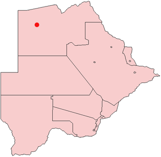
Botswana is a landlocked country located in Southern Africa, north of South Africa. Botswana occupies an area of 581,730 square kilometres (224,610 sq mi), of which 566,730 km2 (218,820 sq mi) are land. Botswana has land boundaries of combined length 4,347.15 kilometres (2,701.19 mi), of which the constituent boundaries are shared with Namibia, for 1,544 km (959 mi); South Africa 1,969 km (1,223 mi); Zimbabwe, 834 km (518 mi) and Zambia, 0.15 km (0.093 mi). Much of the population of Botswana is concentrated in the eastern part of the country.

The Okavango River, is a river in southwest Africa. It is known by this name in Botswana, and as Cubango in Angola, and Kavango in Namibia. It is the fourth-longest river system in southern Africa, running southeastward for 1,600 km (1,000 mi). It begins at an elevation of 1,300 metres (4,300 ft) in the sandy highlands of Angola. Farther south, it forms part of the border between Angola and Namibia, and then flows into Botswana. The Okavango does not have an outlet to the sea. Instead, it discharges into the Okavango Delta or Okavango Alluvial Fan, in an endorheic basin in the Kalahari Desert. The Cuito River is a major tributary.

The Okavango Delta in Botswana is a vast inland delta formed where the Okavango River reaches a tectonic trough at an altitude of 930–1,000 m in the central part of the endorheic basin of the Kalahari.

Maun is the fifth-largest town in Botswana. As of 2011, it had a population of 55,784. Maun is the "tourism capital" of Botswana and the administrative centre of Ngamiland district. Francistown and Maun are linked by the A3 highway. Maun is also the headquarters of numerous safari and air-charter operations who run trips into the Okavango Delta.

The North-West District or Ngamiland is one of the first-level administrative subdivisions of Botswana. For census and administrative purposes Ngamiland is subdivided into Ngamiland East, Ngamiland West and Ngamiland Delta (Okavango). It is governed by a District Commissioner, appointed by the national government, and the elected North-West District Council. The administrative centre is Maun.

Gumare or Gomare is a rural village located in the North-West District of Botswana, near the Okavango Delta. The population of Gumare was 6,067 in 2001 census, but had risen to 8,532 iby the 2011 census.

The Kalahari Basin, also known as the Kalahari Depression, Okavango Basin or the Makgadikgadi Basin, is an endorheic basin and large lowland area covering approximately 725,293 km2 (280,037 sq mi) — mostly within Botswana and Namibia, but also parts of Angola, South Africa, Zambia, and Zimbabwe. The outstanding physical feature in the basin, and occupying the centre, is the large Kalahari Desert.

Maun Airport is an international airport serving the town of Maun in the North-West District of Botswana. It is on the north side of the town and is accessible by shuttle bus or taxi.

Shakawe Airport is an airport serving Shakawe, a village in the North-West District of Botswana.

Shakawe is a village located in the northwest corner of Botswana at the beginning of the Okavango Delta, close to Namibia and Angola. Shakawe is awakening from its former status as a sleepy little outpost on the Okavango. For travellers, Shakawe means a Botswana entry or exit stamp or a staging post for a visit to the Tsodilo Hills, 40 km away. For Southern African holiday-makers, it is most often the start of a fishing trip in the Okavango Panhandle. It also provides access to the Caprivi Strip. The record high temperature ever registered in Shakawe was 39.6 °C (103.3 °F). The lowest temperature registered in Shakawe was −6.1 °C (21.0 °F).

Mack Air is a charter airline based in Maun, Botswana. The company has been operating in northern Botswana since 1994.

The Kalahari Acacia-Baikiaea woodlands are an ecoregion located in Botswana, northern Namibia, South Africa and Zimbabwe.

On 14 October 2011, a Cessna 208 Caravan turboprop passenger aircraft operated by Moremi Air on a domestic flight from Xakanaka camp to Maun, Botswana, crashed and caught fire shortly after take-off, killing eight of the twelve people on board.
Khwai River Airport is an airport serving the lodges and camps around the village of Khwai in Botswana.
Nokaneng Airport is an airport serving the village of Nokaneng on the western edge of the Okavango Delta in Botswana. The runway is 2 kilometres (1.2 mi) southeast of the village.
Xugana Airport is an airstrip serving the Xugana Island Lodge, a safari resort in the Okavango Delta of Botswana.
Camp Okavango Airstrip is a private airstrip serving Camp Okavango, a safari camp in the Okavango Delta, in the North-West District of Botswana.
Xaxaba Airfield is an airstrip 3.5 kilometres (2.2 mi) west of Xaxaba, a village in the Okavango Delta of Botswana. It serves several safari camps in the area. The runway is just outside the Moremi Game Reserve.
Seronga Airport is an airport serving the village of Seronga in the North-West District of Botswana. The well-marked runway is on the northern edge of the Okavango Delta.


