Snowdon is the highest mountain in Wales, at an elevation of 1,085 metres (3,560 ft) above sea level, and the highest point in the British Isles outside the Scottish Highlands. It is located in Snowdonia National Park in Gwynedd.

The Berwyn range is an isolated and sparsely populated area of moorland in the northeast of Wales, roughly bounded by Llangollen in the northeast, Corwen in the northwest, Bala in the southwest, and Oswestry in the southeast.

Kinder Scout is a moorland plateau and national nature reserve in the Dark Peak of the Derbyshire Peak District in England. Part of the moor, at 636 metres (2,087 ft) above sea level, is the highest point in the Peak District, the highest point in Derbyshire, and the highest point in the East Midlands. This summit is sometimes simply called the Peak. In excellent weather conditions the city of Manchester and the Greater Manchester conurbation can be seen, as well as Winter Hill near Bolton, and the mountains of Snowdonia in North Wales.
The National Three Peaks Challenge is an event in which participants attempt to climb the highest mountains of England, Scotland and Wales within 24 hours. It is frequently used to raise money for charitable organisations. Walkers climb each peak in turn, and are driven from the foot of one mountain to the next. The three peaks are:

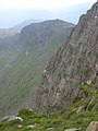
Crib Goch is described as a "knife-edged" arête in the Snowdonia National Park in Gwynedd, Wales. The name means "red ridge" in the Welsh language.

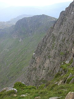
Glaslyn is a lake in the Snowdonia National Park in Gwynedd, north-west Wales.

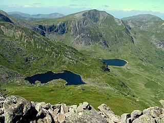
Glyder Fawr is a mountain in Snowdonia, Wales, the highest peak in the Glyderau range at just over 1,000 metres, having had its height recalculated in 2010 using GPS. It is the fifth-highest mountain in Wales and has several walking and scrambling routes leading to its summit. According to Sir Ifor Williams, the word "Glyder" derives from the Welsh word "Gludair", meaning a heap of stones.

Aran Fawddwy is a mountain in southern Snowdonia, Wales, United Kingdom. It is the highest point of the historic county of Merionethshire. It is the only peak in Wales outside North Snowdonia above 900m, and higher than anywhere in Great Britain outside Northern Snowdonia, the Scottish Highlands and the Lake District. The nearest urban centres to the mountain are Dinas Mawddwy to the south, Llanymawddwy to the southeast, Llanuwchllyn on the shores of Bala Lake to the north, and Rhydymain to the west. The nearest settlements with around 2,000 people are Bala and Dolgellau. On the eastern slopes of Aran Fawddwy is the small lake named Creiglyn Dyfi, the source of the River Dyfi. Its sister peak is Aran Benllyn at 885 metres (2,904 ft). There is also a middle peak- Erw y Ddafad-ddu.

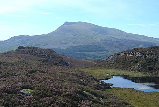
Cader Idris is a mountain in the historic county of Meirionnydd, Wales. It lies at the southern end of the Snowdonia National Park near the town of Dolgellau. The peak, which is one of the most popular in Wales for walkers and hikers, is composed largely of Ordovician igneous rocks, with classic glacial erosion features such as cwms, moraines, striated rocks, and roches moutonnées.
Moel Siabod, is a mountain in Snowdonia, North Wales, which sits isolated above the village of Dolwyddelan. At 872 metres (2,861 ft), it is the highest peak in the Moelwynion mountain range. The UK National Mountain Centre, Plas-y-Brenin, is located at the foot of Moel Siabod. From the top of the mountain, it is reputedly possible to see 13 of the 14 highest peaks in Wales on a clear day without turning one's head.
Cadair Berwyn or Cader Berwyn is a mountain summit in north-east Wales with a height of 832 metres (2,730 ft) above sea level. It is the highest point in the Berwyn range, the highest in North East Wales and the highest significant summit in Wales outside the National Parks. Cadair Berwyn and Foel Cedig to the west are the two Marilyns that form the Berwyn range. The undulating plateau of the range also includes a large number of other summits above 2,000 feet (610 m), including satellite summits of Cadair Berwyn and many which are classed as Nuttalls.
Y Garn is a mountain in Snowdonia, North Wales, part of the Glyderau.

The mountains and hills of the British Isles are categorised into various lists based on different combinations of elevation, prominence, and other criteria such as isolation. These lists are used for peak bagging, whereby hillwalkers attempt to reach all the summits on a given list, the oldest being the 282 Munros in Scotland, created in 1891.

Maesglase is a mountain in Snowdonia, North Wales, situated approximately four miles to the south-west of Aran Fawddwy. It is the highest of the Dyfi Hills.
Lliwedd Bach is a top of Y Lliwedd in the Snowdonia National Park, North Wales. It is the last "top" on the main ridge of Y Lliwedd, the other being Y Lliwedd East Peak. A broad ridge at around 580m carries on northwards until the subsidiary summit of Gallt y Wenallt is reached.

Corn Du is a summit of the twin topped Pen y Fan and the second highest peak in South Wales at 873 m (2,864 ft), situated in the Brecon Beacons National Park. The summit itself is marked by a well structured Bronze Age cairn with a central burial cist like that on nearby Pen y Fan. The two summits are visible from great distances owing to their height above the surrounding moorland, and are famous landmarks. The views from the peaks are also panoramic and very extensive, the Black Mountain and Fforest Fawr being especially obvious to the west. Mynydd Epynt is visible to the north behind the county town of Brecon, and other parts of the escarpment to the east.

Carnedd y Filiast is a mountain near Cerrigydrudion on the border of the Snowdonia National Park, North Wales and is 669 metres (2,195 ft) high.

Fountains Fell is a mountain in the Yorkshire Dales, England. The main summit has a height of 668 metres (2,192 ft) and a relative height or topographic prominence of 243 metres (797 ft) and thus qualifies as a Marilyn. Its subsidiary, Fountains Fell South Top reaches 662 metres (2,172 ft) and qualifies as a Nuttall. A third summit, further south at SD868697, reaches 610 metres (2,001 ft) and is the most southerly 2,000 ft summit in the Pennines.

Gallt y Wenallt is a subsidiary summit of Y Lliwedd in Snowdonia National Park, north Wales. It lies at the end of the north ridge. Its northern face is reputed to be the longest slope in Snowdonia, being close to 2000 ft. It is also the last nail in the "completist's" Snowdon Horseshoe.