Yage Taung

Last updated
Yage Taung
Myanmar adm location map.svg
Red triangle with thick white border.svg
Yage Taung
Location in Burma
Highest point
Elevation 978 m (3,209 ft) [1]
Coordinates 12°46′29″N99°13′17″E / 12.77472°N 99.22139°E / 12.77472; 99.22139 Coordinates: 12°46′29″N99°13′17″E / 12.77472°N 99.22139°E / 12.77472; 99.22139 [2]
Geography
Location Tanintharyi Region, Myanmar
Parent range Tenasserim Hills
Climbing
First ascent unknown
Easiest route climb

Yage Taung is a mountain of the Tenasserim Hills, Burma. [3] This mountain rises within the Tanintharyi National Park which is coterminous with the Kaeng Krachan National Park zone over the border with Thailand. [4]

Tenasserim Hills

Tenasserim Hills or Tenasserim Range is the geographical name of a roughly 1,700 km long mountain chain, part of the Indo-Malayan mountain system in Southeast Asia.

Tanintharyi National Park

The Tanintharyi National Park is a demarcated national park located in the Tenasserim Hills, Burma, further south from the Tanintharyi Nature Reserve in the border area with Thailand. It is governed by the Burma Forest Service and the level of protection is total. The altitudes within the park range from sea level to 1,490 m.

Kaeng Krachan National Park

Kaeng Krachan National Park is the largest national park of Thailand. It is on the border with Burma, contiguous with the Tanintharyi Nature Reserve. It is a popular park owing to its proximity to the tourist town of Hua Hin.

Contents

Geography

Yage Taung is located in a wooded and largely uninhabited area of the Tanintharyi Region, 1.4 km to the west of the border with Thailand. The closest conspicuous peaks are 1,431 m high Palan Taung rising less than 6 km to the NNW and 1,315 m high Yekye Tong to the SSE, also by the Thai border. [2]

Tanintharyi Region Region in South, Myanmar

Tanintharyi Region is an administrative region of Myanmar, covering the long narrow southern part of the country on the Kra Isthmus. It borders the Andaman Sea to the west and the Tenasserim Hills, beyond which lie Thailand, to the east. To the north is the Mon State. There are many islands off the coast, the large Mergui Archipelago in the southern and central coastal areas and the smaller Moscos Islands off the northern shores. The capital of the division is Dawei (Tavoy). Other important cities include Myeik (Mergui) and Kawthaung. The division covers an area of 43,344.9 km², and had a population of 1,406,434 at the 2014 Census.

Thailand Constitutional monarchy in Southeast Asia

Thailand, officially the Kingdom of Thailand and formerly known as Siam, is a country at the center of the Southeast Asian Indochinese peninsula composed of 76 provinces. At 513,120 km2 (198,120 sq mi) and over 68 million people, Thailand is the world's 50th largest country by total area and the 21st-most-populous country. The capital and largest city is Bangkok, a special administrative area. Thailand is bordered to the north by Myanmar and Laos, to the east by Laos and Cambodia, to the south by the Gulf of Thailand and Malaysia, and to the west by the Andaman Sea and the southern extremity of Myanmar. Its maritime boundaries include Vietnam in the Gulf of Thailand to the southeast, and Indonesia and India on the Andaman Sea to the southwest. Although nominally a constitutional monarchy and parliamentary democracy, the most recent coup in 2014 established a de facto military dictatorship.

The nearest inhabited place on the Burmese side is Natthi, a riverside village located 26 km to the WSW. [3]

History

On 19 July 2011, a Royal Thai Army Sikorsky UH-60 Black Hawk helicopter crashed in the Yage Taung mountainside, killing 9. The chopper had been sent out to recover five bodies of victims of another helicopter crash involving a Bell UH-1 Iroquois that had occurred two days earlier while looking for illegal loggers in Kaeng Krachan National Park near the Burmese border west of Phetchaburi. [5]

Royal Thai Army army of Thailand

The Royal Thai Army or RTA is the army of Thailand responsible for protecting its sovereignty and national interests. It is the oldest and largest branch of the Royal Thai Armed Forces.

Sikorsky UH-60 Black Hawk Series of military utility transport helicopters

The Sikorsky UH-60 Black Hawk is a four-bladed, twin-engine, medium-lift utility helicopter manufactured by Sikorsky Aircraft. Sikorsky submitted the S-70 design for the United States Army's Utility Tactical Transport Aircraft System (UTTAS) competition in 1972. The Army designated the prototype as the YUH-60A and selected the Black Hawk as the winner of the program in 1976, after a fly-off competition with the Boeing Vertol YUH-61.

Bell UH-1 Iroquois Family of military utility helicopters

The Bell UH-1 Iroquois is a utility military helicopter powered by a single turboshaft engine, with two-blade main and tail rotors. The first member of the prolific Huey family, it was developed by Bell Helicopter to meet a United States Army's 1952 requirement for a medical evacuation and utility helicopter, and first flew in 1956. The UH-1 was the first turbine-powered helicopter produced for the United States military, and more than 16,000 have been built since 1960.

A third helicopter, a Bell 212, also crashed in the same area on Sunday, 25 July a few miles further east close to the Kaeng Krachan Reservoir. [6] Superstitious people blamed the three consecutive helicopter crashes on the belief that the densely forested mountains of the Tenasserim Range have strong guardian spirits according to Thai folklore. [7]

Bell 212 utility transport helicopter family by Bell

The Bell 212 is a two-blade, twin-engine, medium helicopter that first flew in 1968. Originally manufactured by Bell Helicopter in Fort Worth, Texas, United States, production was moved to Mirabel, Quebec, Canada in 1988, along with all Bell commercial helicopter production after that plant opened in 1986.

A tutelary is a deity or spirit who is a guardian, patron, or protector of a particular place, geographic feature, person, lineage, nation, culture, or occupation. The etymology of "tutelary" expresses the concept of safety, and thus of guardianship.

Thai folklore

Thai folklore is a diverse set of mythology and traditional beliefs held by the Thai people. Most Thai folklore has a regional background for it originated in rural Thailand. With the passing of time, and through the influence of the media, large parts of Thai folklore have become interwoven with the wider popular Thai culture.

See also

Related Research Articles

Prachuap Khiri Khan Province Province in Thailand

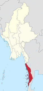
Prachuap Khiri Khan is one of the western provinces (changwat) of Thailand. It is in the northern part of the Malay Peninsula, some 240 km (150 mi) south of Bangkok. Neighboring provinces are Phetchaburi to the north and Chumphon to the south. To the west it borders Tanintharyi Region of Myanmar.

Ratchaburi Province Province in Thailand

Ratchaburi Province or Rat Buri is one of the western provinces (changwat) of Thailand. Neighbouring provinces are Kanchanaburi, Nakhon Pathom, Samut Sakhon, Samut Songkhram and Phetchaburi. In the west it borders the Tanintharyi Region of Myanmar.

Phetchaburi Province Province in Thailand

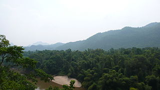
Phetchaburi or Phet Buri is one of the western or central provinces (changwat) of Thailand. Neighboring provinces are Ratchaburi, Samut Songkhram, and Prachuap Khiri Khan. In the west it borders the Tanintharyi Division of Myanmar. Phetchaburi has a national park called "Kaeng Krachan" which consists of a reservoir overlooking its islands.

Western Thailand Region in Hua Hin

Western Thailand is a region of Thailand bordering Myanmar on the west, Southern Thailand on the south, and central Thailand on the east.

The Phetchaburi River is a river in western Thailand. It has its source in the Tenasserim Hills, in the Kaeng Krachan National Park, Kaeng Krachan district and flows through Tha Yang, Ban Lat, Mueang Phetchaburi and mouths into the Bay of Bangkok in Ban Laem district. It is 210 kilometres (130 mi) long, most of which is within the Phetchaburi Province. It is the backbone of this province.

Kaeng Krachan District District in Phetchaburi, Thailand

Kaeng Krachan is a district (amphoe) of Phetchaburi Province, western Thailand.

Nong Ya Plong District District in Phetchaburi, Thailand

Nong Ya Plong is a district (amphoe) in the northwestern part of Phetchaburi Province, western Thailand.

Western Forest Complex

The Western Forest Complex, straddling two countries, Thailand and Myanmar, including 19 national parks and wildlife sanctuaries, is the main biodiversity conservation corridor of the region. Covering 18,730 km2, it is one of the largest protected territories in Southeast Asia. The geography of the Western Forest Complex ranges from lowlands to the mountains of the Thai highlands and the Dawna-Tenasserim Hills.

Bilauktaung

Bilauktaung is a subrange of the Tenasserim Hills. It is located in Burma on the border with Thailand. It extends from the Dawna Range for about 400 km along the frontier area to the Kra Isthmus.

Tanintharyi Nature Reserve

The Tanintharyi Nature Reserve is a nature reserve in the Tenasserim Hills, Burma, north of Tanintharyi National Park on the border with Thailand, adjacent to Kaeng Krachan National Park. It is governed by the Burma Forest Department and the level of protection is partial. Elevations within the reserve range from 20–1,300 m. Tourists are not permitted within the nature reserve.

Myinmoletkat Taung mountain in Myanmar

Myinmoletkat Taung is the highest mountain of the Bilauktaung, Tenasserim Hills, Burma.

Kaeng Krachan Dam

The Kaeng Krachan Dam is a multi-purpose hydroelectric dam in the Kaeng Krachan District of Phetchaburi Province, Thailand. The dam impounds the Phetchaburi River. It was officially opened in 1966 by King Bhumibol and Queen Sirikit.

Dawna Range

The Dawna Range, also known as Dawna Hills, is a mountain range in eastern Burma and northwestern Thailand. Its northern end is located in Kayah State where it meets the Daen Lao Range, a subrange of the Shan Hills. The range runs southwards along Kayin State as a natural border with Mon State in the west forming parallel ranges to the northern end of the Tenasserim Hills further south and southeast. The Dawna Range extends east of the Salween southwards from the Shan Hills for about 350 km, at the western limit of the Thai highlands. Its southern end reaches the Thai-Myanmar border in the Umphang area, entering Thailand west of Kamphaeng Phet. The Thungyai Naresuan Wildlife Sanctuary is in the Thai side of the range.

Sinbyudaing Town in Taninthayi Region, Burma

Sinbyudaing, also known as Sin Byu Daing, is a small town of Dawei District in the Taninthayi Division of Myanmar. It is located on the western side of the Tenasserim Range near the border with Thailand.

Baulu Taung mountain in Myanmar

Baulu Taung is a mountain of the Tenasserim Hills, Burma.

Kyaukton Village in Taninthayi Region, Burma

Kyaukton, is a village of Dawei District in the Taninthayi Division of Myanmar. It is located on the western side of the Tenasserim Range, 24 km to the northwest of Sinbyudaing.

Porlajee "Billy" Rakchongcharoen, a Karen environmental and community activist, was last seen in Kaeng Krachan National Park, western Phetchaburi Province, Thailand on 17 April 2014. He was arrested at a park checkpoint by park superintendent Chaiwat Limlikitaksorn and four of his men for alleged illegally collecting wild honey in the forest. Three years earlier, in 2011, Billy had filed a lawsuit against Chiwat over the May 2011 destruction and burning of houses, and eviction of over 20 Karen families living in the park's Pong Luk Bang Kloy village, in the Huai Mae Phriang Sub-district of Kaeng Krachan District. The national park chief later swore that Billy had been arrested and released on the same day after being questioned for possession of an illegal wild bee honeycomb and six bottles of honey. There are no official records of his arrest or detention. Following Billy's arrest he was never seen again.

References