Yarm Town Hall

Last updated

Yarm Town Hall
War Memorial and Yarm Town Hall (geograph 3277649).jpg
Yarm Town Hall
LocationHigh Street, Yarm
Coordinates 54°30′33″N1°21′15″W / 54.5092°N 1.3543°W / 54.5092; -1.3543
Built1710
Architectural style(s) Dutch style
Listed Building – Grade II
Official nameTown Hall
Designated5 May 1952
Reference no.1329488
North Yorkshire UK location map (2023).svg
Red pog.svg
Shown in North Yorkshire

Yarm Town Hall is a municipal building in the High Street in Yarm, North Yorkshire, England. The structure, which is the meeting place of Yarm Town Council, is a Grade II listed building. [1]

History

The Second Boer War Memorial South African War Memorial, Yarm Town Hall (geograph 2344880).jpg
The Second Boer War Memorial

The first building on the site was a medieval tollbooth erected to enable the lord of the manor collect tolls from people on the north-south coaching route between London and Edinburgh. [2] The town was an important coaching stop located just south of the bridge across the River Tees. [3] A bell to be rung in case of flooding or fire was installed in the belfry in 1690: it was inscribed: "Si Deus pro nobis ouis contra nos." (English: If God is for us, who can be against us?) [4] When the old tollbooth became dilapidated, the then lord of the manor, Thomas Belasyse, 3rd Viscount Fauconberg, decided to demolish it and to replace it with a new structure. [4]

The new building was designed in the Dutch style, built in red brick and completed in 1710. [5] The building was arcaded on the ground floor, so that markets could be held, with a room for the administration of tolls on the first floor. The design involved a symmetrical main frontage with two bays facing south along the High Street; there were sash windows on the first floor and it featured a pyramid-shaped roof with a square clock tower, a belfry and a weather vane. [1] The bell for the new building had been recovered from the old tollbooth. [6]

The new building continued to operate as a tollbooth, especially after the Catterick Bridge to Durham turnpike road opened in 1747, [7] and was still referred to as a tollbooth in the early 19th century. [8] The building also served as the venue for court hearings held by the lord of the manor and, later, by the local magistrates. [9] It appeared, by 1824, to have a "ruinous and unseemly appearance" [8] but, after repairs were carried out in the mid-19th century, it was described as "a neat building". [10]

After a heavy flood on 17 September 1771, a plaque was installed in the building to record the level of the flood and a second plaque, recording a less severe flood on 10 March 1881, was installed on the south elevation of the building following that event. [11] Some of the arches were bricked up in 1888 to accommodate a set of imperial measures, typically held by local authorities to ensure tradesmen comply with the Weights and Measures Act 1824. [12]

A plaque to commemorate the lives of service personnel who had served with the Prince of Wales's Own Regiment of Yorkshire and with the Imperial Yeomanry in the Second Boer War was installed on the south face of the building in the early 20th century [4] and a memorial to commemorate the lives of service personnel who had died in the First World War was unveiled in front of the building by the Lord Lieutenant of the North Riding of Yorkshire, Sir Hugh Bell, on 12 June 1920. [13] Another plaque to commemorate the lives of local people who had served on the local committee of the Stockton and Darlington Railway was installed on the face of the building to mark the centenary of the railway in 1925. [4]

The remaining open arches were bricked up when it was decided that the building should accommodate public toilets in the 1930s. [4] For administrative purposes the town developed as a civil parish, [14] and, after it was designated an ecclesiastical parish in 1865, the parish council, which became known as Yarm Town Council, continued to use the building as its regular meeting place. [4]

Related Research Articles

<span class="mw-page-title-main">North Yorkshire</span> County of England

North Yorkshire is a ceremonial county in the Yorkshire and the Humber and North East regions of England. It borders County Durham to the north, the North Sea to the east, the East Riding of Yorkshire to the south-east, South Yorkshire to the south, West Yorkshire to the south-west, and Cumbria and Lancashire to the west.

<span class="mw-page-title-main">Yarm</span> Town and civil parish in North Yorkshire, England

Yarm, also referred to as Yarm-on-Tees, is a market town and civil parish in the Borough of Stockton-on-Tees, North Yorkshire, England. It is in Teesdale with a town centre on a small meander of the River Tees. To the south-east, it extends to the River Leven, to the south it extends into the Kirklevington.

<span class="mw-page-title-main">Stockton-on-Tees</span> Town in County Durham, England

Stockton-on-Tees, often simply referred to as Stockton, is a market town in the Stockton-on-Tees unitary authority borough of County Durham, England. With a population of 84,815 in the 2021 UK census. It is part of the Teesside and the devolved Tees Valley area, on the northern banks of the River Tees.

<span class="mw-page-title-main">Thornaby-on-Tees</span> Town and civil parish in North Yorkshire, England

Thornaby-on-Tees, commonly referred to as Thornaby, is a town and civil parish on the River Tees's southern bank. It is in the Borough of Stockton-on-Tees, North Yorkshire, England. The parish had a population of 24,741 at the 2011 census, in the Teesside built-up area.

<span class="mw-page-title-main">Borough of Stockton-on-Tees</span> Unitary authority area in County Durham, England

The Borough of Stockton-on-Tees is a unitary authority with borough status in the counties of County Durham and North Yorkshire, England. The borough had a population of 196,600 in 2021.

<span class="mw-page-title-main">Ingleby Barwick</span> Town and civil parish in North Yorkshire, England

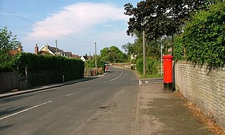
Ingleby Barwick is a town and civil parish in the Borough of Stockton-on-Tees, North Yorkshire, England. It is south of the River Tees and north-east of the River Leven.

<span class="mw-page-title-main">Tees Valley</span> Mayoral combined authority area in North East England

The Tees Valley is a combined authority area in North East England, around the lower River Tees. The area is not a geographical valley; the local term for the valley is Teesdale. The combined authority covers five council areas: Darlington, Hartlepool, Middlesbrough, Redcar and Cleveland and Stockton-on-Tees.

<span class="mw-page-title-main">Egglescliffe</span> Village and civil parish in County Durham, England

Egglescliffe is a village and civil parish in County Durham, England. Administratively it is located in the borough of Stockton-on-Tees.

<span class="mw-page-title-main">Kirklevington</span> Village and civil parish in North Yorkshire, England

Kirklevington is a village in the borough of Stockton-on-Tees, North Yorkshire, England. At the 2011 census, the village had a population of 809.

<span class="mw-page-title-main">Langbaurgh West</span> Ancient division of the North Riding, Yorkshire, England

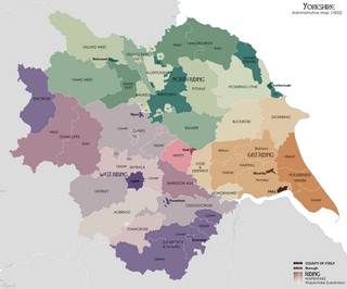
Langbaurgh West was a division of the wapentake of Langbaurgh in the North Riding of the ancient county of Yorkshire. The area along with Langbaurgh East forms the Anglo-Saxon baronial Liberty of Cleveland and roughly covers the modern districts of Middlesbrough, the western, urbanised portion of Redcar & Cleveland, the southern portion of Stockton-on-Tees, the northern parts of Hambleton and the northern parts of the Borough of Scarborough.

<span class="mw-page-title-main">St Mary Magdalene, Yarm</span> Church of England parish church in Yarm, North Yorkshire, England

St Mary Magdalene is a Church of England parish church in the town of Yarm, in the Borough of Stockton-on-Tees, North Yorkshire, England, which is dedicated to Jesus' companion Mary Magdalene. Administratively, it is a parish of the Diocese of York. The current rector is the Reverend Darren Moore.

<span class="mw-page-title-main">Yarm School</span> Public school in Yarm, Stockton-on-Tees, England

Yarm School is a co-educational independent day school in Yarm, North Yorkshire in the North East of England. The school accepts pupils aged 3–18 years old and has a Nursery Pre-Prep, Preparatory School, Senior School and Sixth Form. The School was founded in 1978 and is a member of the Headmasters' and Headmistresses' Conference.

The High Sheriff of Cleveland was a High Sheriff title which was in existence from 1974 until 1996, covering Cleveland, England.

<span class="mw-page-title-main">Yarm Viaduct</span> Railway viaduct over the River Tees in England

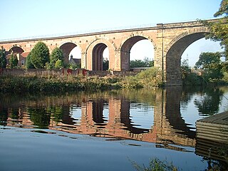
Yarm Viaduct is a railway viaduct carrying the railways above the town of Yarm in North Yorkshire, England. It crosses the River Tees which forms the boundary between North Yorkshire and County Durham. The railway runs between Northallerton and Eaglescliffe, and was opened in 1852 as part of the extension of the Leeds Northern Railway to Stockton-on-Tees. The line and viaduct are currently owned and maintained by Network Rail and carries passenger traffic for TransPennine Express and Grand Central train operating companies. It also sees a variety of freight traffic.

<span class="mw-page-title-main">Church of St Peter ad Vincula, Thornaby-on-Tees</span> Anglican church in North Yorkshire, England

The Church of St Peter ad Vincula, Thornaby, is an Anglican church in Thornaby, North Yorkshire, England. The structure, which is grade II* listed, is dated to the 12th century, replacing an earlier building on the same site. The church is noted for being the supposed baptismal location of Grace Pace, Captain Cook's mother.

<span class="mw-page-title-main">Guisborough Town Hall</span> Municipal building in Guisborough, North Yorkshire, England

Guisborough Town Hall is a municipal building on Westgate in Guisborough, North Yorkshire, England. The structure, which has mainly been used as a venue for magistrates' court hearings, is a Grade II listed building.

<span class="mw-page-title-main">South Cave Town Hall</span> Municipal building in South Cave, East Riding of Yorkshire, England

South Cave Town Hall is a municipal building in the Market Place, South Cave, East Riding of Yorkshire, England. The building, which is the meeting place of South Cave Parish Council, is a Grade II listed building.

<span class="mw-page-title-main">Helmsley Town Hall</span> Municipal building in Helmsley, North Yorkshire, England

Helmsley Town Hall is a municipal building in the Market Place in Helmsley, North Yorkshire, England. The structure, which is used as a community library and a community events centre, is a grade II listed building.

<span class="mw-page-title-main">Leyburn Town Hall</span> Municipal building in Leyburn, North Yorkshire, England

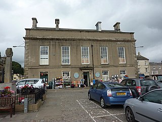
Leyburn Town Hall is a municipal building in the Market Place, Leyburn, North Yorkshire, England. The structure, which is used for retail purposes and as an events venue, is a grade II listed building.

<span class="mw-page-title-main">Stokesley Town Hall</span> Municipal building in Stokesley, North Yorkshire, England

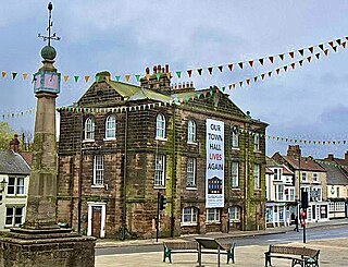
Stokesley Town Hall is a municipal building in the Market Place in Stokesley, North Yorkshire, England. The structure, which accommodates the offices and meeting place of Stokesley Town Council, is a grade II listed building.

References

  1. 1 2 Historic England. "Town Hall (1329488)". National Heritage List for England . Retrieved 16 June 2021.
  2. Chrystal, Paul; Laundon, Stan (2015). Secret Middlesbrough. Amberley Publishing. ISBN   978-1445646763.
  3. Historic England. "Yarm Bridge over River Tees (1105658)". National Heritage List for England . Retrieved 16 June 2021.
  4. 1 2 3 4 5 6 "Yarm Town Hall". Stockton-on-Tees Borough Council. Retrieved 16 June 2021.
  5. "Old photos of Yarm - an extremely attractive town with a rich history". Northern Echo. 19 August 2017. Retrieved 16 June 2021.
  6. "A brief History of Yarm" (PDF). Stockton-on-Tees Borough Council. Retrieved 16 June 2021.
  7. "Yorkshire, North Riding". Turnpikes. Retrieved 16 June 2021.
  8. 1 2 Mogg, Edward (1824). Patterson's Roads. Longman, Hurst, Rees, Orme, Brown and Green. p. 570.
  9. Page, William (1923). "'Parishes: Yarm', in A History of the County of York North Riding". London: British History Online. pp. 319–326. Retrieved 16 June 2021.
  10. Fordyce, William (1857). The History and Antiquities of the County Palatine of Durham. A. Fullarton and Company.
  11. "Yarm 1881 Flood Marker". Hidden Teesside. Retrieved 15 May 2021.
  12. "Made to measure". Daventry Express. 11 March 2017. Retrieved 15 May 2021.
  13. Historic England. "Yarm War Memorial (1467852)". National Heritage List for England . Retrieved 16 June 2021.
  14. "Yarm CP/AP/Ch". Vision of Britain. Retrieved 15 May 2021.