Jammu and Kashmir was a region formerly administered by India as a state from 1954 to 2019, constituting the southern and southeastern portion of the larger Kashmir region, which has been the subject of a dispute between India, Pakistan and China since the mid-20th century. The underlying region of this state were parts of the former princely state of Jammu and Kashmir, whose western districts, now known as Azad Kashmir, and northern territories, now known as Gilgit-Baltistan, are administered by Pakistan. The Aksai Chin region in the east, bordering Tibet, has been under Chinese control since 1962.

Alameda County is located in the state of California in the United States. As of the 2010 census, the population was 1,510,271, making it the 7th-most populous county in the state and 20th most populous nationally. The county seat is Oakland. Alameda County is included in the San Francisco Bay Area, occupying much of the East Bay region.

San Bernardino County, officially the County of San Bernardino, is a county located in the southern portion of the U.S. state of California, and is located within the Inland Empire area. As of the 2010 U.S. Census, the population was 2,035,210, making it the fifth-most populous county in California and the 14th-most populous in the United States. The county seat is San Bernardino.

In the United States, a county is an administrative or political subdivision of a state that consists of a geographic region with specific boundaries and usually some level of governmental authority. The term "county" is used in 48 U.S. states, while Louisiana and Alaska have functionally equivalent subdivisions called parishes and boroughs, respectively.

Washington, D.C., formally the District of Columbia and also known as D.C. or Washington, is the capital city of the United States of America. It is located on the Potomac River bordering Maryland and Virginia, with Congress holding its first session there in 1800. The city was named for George Washington, the first president of the United States and a Founding Father, and the federal district is named after Columbia, a female personification of the nation. As the seat of the U.S. federal government and several international organizations, the city is an important world political capital. It is one of the most visited cities in the U.S., with over 20 million visitors in 2016.

These are tables of congressional delegations from New York to the United States House of Representatives and the United States Senate.

The Districts of Pakistan ; are the third-order administrative divisions of Pakistan, below provinces and divisions, but forming the first tier of local government. In total, there are 130 districts in Pakistan, including the Islamabad Capital Territory, 10 districts in Pakistan's dependent territory of Azad Kashmir, and 14 districts in Pakistan's dependent territory of Gilgit Baltistan. Districts are divided into tehsils, which are further divided into union councils.

These are tables of congressional delegations from Pennsylvania to the United States House of Representatives and the United States Senate.
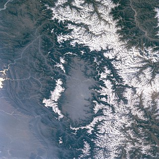
The Kashmir Valley, also known as the Vale of Kashmir, is an intermontane valley in the portion of the Kashmir region administered by India. The valley is bounded on the southwest by the Pir Panjal Range and on the northeast by the main Himalayas range. It is approximately 135 km (84 mi) long and 32 km (20 mi) wide, and drained by the Jhelum River.

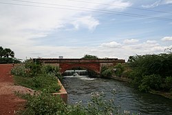
Bathinda district is in Malwa region of Punjab, India. The districts encompass an area of 3,385 square kilometers. By area, Bathinda District is the third-largest in Punjab. It is bounded by Faridkot district and Moga district on the north, Mukatsar district on the west, Barnala and Mansa districts on the east, and the state of Haryana on the south. Bathinda is cotton producing belt of Punjab.

Jammu and Kashmir is a region administered by India as a union territory and consists of the southern portion of the larger Kashmir region, which has been the subject of a dispute between India and Pakistan since 1947, and between India and China since 1962. The region of Jammu and Kashmir is separated by the Line of Control from the Pakistani-administered territories of Azad Kashmir and Gilgit-Baltistan in the west and north, respectively. It lies to the north of the Indian states of Himachal Pradesh and Punjab and to the west of Ladakh, which is also subject to the dispute as a part of Kashmir, and administered by India as a union territory.