
Ahobilam is a town and holy site in the Allagadda mandal of Nandyal district in the Indian state of Andhra Pradesh. It is surrounded by picturesque hills of the Eastern Ghats with several mountain hills and gorges. It is the centre of worship of Narasimha, the lion-headed avatar of Vishnu, to whom the nine Hindu temples and other shrines all dedicated. The main village and a temple complex are at Lower Ahobilam. Upper Ahobilam, about 8 kilometres to the east, has more temples in a steep gorge.

Nagari is a town in Chittoor district of the Indian state of Andhra Pradesh. It is the mandal headquarters of Nagari mandal in Nagari revenue division.

Puttur is a town in Tirupati district of the Indian state of Andhra Pradesh. It is the mandal headquarters of Puttur mandal in Tirupati revenue division. It is known for a traditional method of splinting/bandaging bone fractures.
Bichkunda or Bichkonda is a Mandal in Kamareddy district of state of Telangana, India.
Giddaluru is a town in the Prakasam district of the Indian state of Andhra Pradesh. It is the mandal headquarters of the Giddaluru mandal in Markapur revenue division. It was part of kurnool district till 1969 later it was merged into Prakasam district in 1970. Till 2008 it was under Nandyal parliament segment after delimitation it was moved to Ongole MP segment. Giddalur is also known as "3 zilla la muddu bidda " because during the Britishers rule it was in kadapa district later moved to kurnool then in 1970 merged in prakasam district. Giddalur is the only constituency in coastal districts which has Rayalseema culture,slang and traditions. Giddalur town has good transport connectivity to Nandyal, Markapur, Podili, Ongole, Kurnool, Kadapa.
Beluguppa is a village in Anantapur district of the Indian state of Andhra Pradesh. It is the headquarters of Beluguppa mandal in Kalyandurg revenue division.
Penumuru is a village in Chittoor district of the Indian state of Andhra Pradesh. It is the mandal headquarters of Penumuru mandal.

Yerpedu is a place situated in Tirupati district of the Indian state of Andhra Pradesh. It is a part of Tirupati suburb and is located near Sri Kalahasti. It falls in the jurisdictional limit of Tirupati Urban Development Authority. It is the mandal headquarters of Yerpedu mandal.
Karempudi is a village in Palnadu district of the Indian state of Andhra Pradesh. It is the headquarters of Karempudi mandal in Gurazala revenue division.
Komarolu is a village in Prakasam district of the Indian state of Andhra Pradesh. It is the mandal headquarters of Ardhaveedu mandal in Markapur revenue division.
Gonegandla is a village in Gonegandla mandal in Kurnool district of Andhra Pradesh, India.
Singanamala is a village in Anantapur district of the Indian state of Andhra Pradesh. It is the mandal headquarters of Singanamala in Anantapur revenue division.
Duggondi is a village and a mandal in Warangal district in the state of Telangana in India.
Talakona is situated in Tirupati district of Andhra Pradesh, India. It is a resort with waterfalls, dense forests and wildlife. Talakona waterfall is in Sri Venkateswara National Park, Tirupati district of Andhra Pradesh. With a 270 feet (82 m)-fall, Talakona is the highest waterfall in Andhra Pradesh state. Talakona is also known for the Lord Siddheswara Swamy Temple, which is located close to the waterfall.
Nerabailu is a village in Yerravaripalem Mandal of Tirupati district.
Kohir Deccan is a town and Mandal headquarters in the Sangareddy district of Telangana, India. Kohir is on the Deccan Plateau in Telangana, neighbouring Karnatake state (Bidar). Kohir, Zaheerabad, Bidar, and neighbouring places brings to mind the Red Planet, and the land is usually red roads, red stones on streets with red houses made of red soil and black soil in agriculture land. Kohir was named after the distinctive red soil of the region. Kohir in local slang means "red diamond". The "Pati Matti" once mixed with water turns into very strong material fit for construction of multistoried buildings. These mud houses are unbreakable and can withstand even the harsh climate of this region. Kohir is bounded by Zahirabad, Jharasangam and Munpalle mandals of Sangareddy district and Rangareddy district.
Jangaon Assembly constituency is a constituency of Telangana Legislative Assembly, India. It is one of 3 constituencies in Jangaon district and 12 constituencies in undivided Warangal district. It is part of Bhuvanagiri Lok Sabha constituency.
Kandukur Revenue Division is an administrative division in the Nellore district of the Indian state of Andhra Pradesh. It is one of the 4 revenue divisions in the district which consists of 7 mandals under its administration. Kandukur is the administrative headquarters of the division.
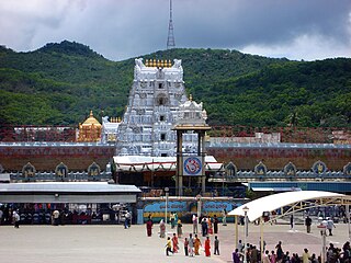
Tirupati district is one of the eight districts of Rayalaseema region in the Indian state of Andhra Pradesh. The district headquarters is located at Tirupati city. This district is known for its numerous historic temples, including the Hindu shrine of Tirumala Venkateswara Temple and Sri Kalahasteeswara temple. The district is also home to Satish Dhawan Space Centre, a rocket launch centre located in Sriharikota. The river Swarnamukhi flows through Tirupati, Srikalahasti, Naidupeta, Vakadu and join into the Bay of Bengal.
Yerravaripalem mandal is one of the 34 mandals in Tirupati district in the Indian state of Andhra Pradesh. It is a part of Tirupati revenue division.

