
Kumbhoj is the name of an ancient town located in Kolhapur district in Maharashtra. The town is about eight kilometers from Hatkanangale, about twenty seven kilometers from Kolhapur and currently, also is the Taluka or Tehsil Headquarters. The famous Jain Tirtha known as Bahubali, is just two kilometers away from the Kumbhoj city.

Wai is a town in Satara district of Maharashtra state in India. Located on the Krishna River, Wai was a prominent town during the Peshwa era. Two important Marathi Brahmin from ruling families had their origins here: Rani Lakshmibai of Jhansi and Gopikabai, wife of Nanasaheb Peshwa.

Satara district is a district of Maharashtra state in western India with an area of 10,480 km2 (4,050 sq mi) and a population of 3,003,741 of which 14.17% were urban. Satara is the capital of the district and other major towns include Medha, Wai, Karad, Malkapur, Koregaon, Rahimatpur, Dahiwadi, Koynanagar, Phaltan, Lonand, Mahabaleshwar, Panchgani, Vaduj and Mhaswad. This district comes under Pune Administrative Division along with Pune, Sangli, Solapur and Kolhapur. The district of Pune bounds it to the north, Raigad bounds it to the north-west, Solapur the east, Sangli to the south, and Ratnagiri to the west.Satara is home to number of maratha warriors such as Hambirrao Mohite,Prataprao Gujar,Tanaji Malusare,Shindes of Kanherkhed etc
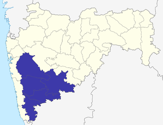
Pune Division is one of the six administrative divisions of the Indian State of Maharashtra. Pune Division is bound by Konkan Division to the west, Nashik Division to the north, Aurangabad Division to the east, and the state of Karnataka to the south.

Sangli district is a district of Maharashtra state in India. Sangli city is the district headquarters. It is bordered by Satara district, Solapur district to the North, Karnataka state to the South-East, by Kolhapur district to South-West and by narrow portion on the East side to Ratnagiri district. It is present on the southern tip of Maharashtra.
Tasgaon is a city in Maharashtra and Taluka in Sangli district in the Indian state of Maharashtra. Tasgaon city is developing city in Maharashtra. Tasgaon was given as Jahagir to Parshuram Bhau Tasgaonkar by Narayanrao Ballal Peshwa in 1774. Tasgaon Sansthan was lapsed by British during ruling of Shrimant Ganpatrao Tasgaonkar.
Khatav is a town and taluka located in the Man-Khatav subdivision of the Satara district, India.
Atpadi is an administrative town of the Atpadi Taluka of Sangli District in the Indian state of Maharashtra. Atpadi is located north-east of Sangli District and shares borders with the adjacent Solapur and Satara Districts. The town has a taluka administrative office, a courthouse, a police station, a government-run primary hospital, various schools and colleges and a theater. Atpadi's economy is based on the cultivation and sale of agricultural products, with pomegranates and cotton constituting the core of the industry. The town is also home to the Manganga Sahakari Sugar factory, a Pomegranate auction center and various small scale industries in fields such as manufacturing, processing, servicing and repairs.
Jakhangaon is a village in the Khatav Taluka (subdistrict) of the Satara district in the Indian state Maharashtra. Jakhangaon's village-deity is Bhairavnath. 60-70% of Jakhandgaon's land is irrigated. The famous Aundh Tirthakshetra is about 13 km from here. This holy place has the temple of Yamaai Devi. Sevagiri Maharaj's temple is situated at 10 km north of Jakhangaon in Pusegaon.
Jat is a town and taluka headquarters in Miraj subdivision of Sangli district in southern Maharashtra.
Kadegaon is a village and taluka of Sangli district of Maharashtra in India.
Pachwad, Panchwad or Kasabe Panchwad is a village in Wai taluka, Satara district, Maharashtra, India. It is situated on the bank of the Krishna River. The Indian National Highway (NH4) passes through the village. Pachwad is a market place for surrounding villages. Pachwad is famous for weekly market of vegetables.

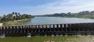
Dhom Dam is an earthfill and gravity dam on Krishna River near Wai in state of Maharashtra in India.

Padali is a census village in Karad Taluka, Satara District, Maharashtra, India. It is surrounded by mountains on three sides. There is a temple of Heljaidevi Mandir. The main occupation of the village is agriculture, with more than 75% of the total area being used for agricultural activities.

Ninam is a census village in Satara district, in the Indian state of Maharashtra. It is a village surrounded by greenery and farms but also mountains. Agriculture is the main land use in the village with more than 75% of the total area being used for agricultural activities. The village close to historic Ajinkyatara fort, which is to the north. The large Jyotirlinga temple is in the center of the village.
Upalavi is a village in the Tehsil tasgaon of Sangli district, Maharashtra, India, about 18 kilometres north of Sangli. It is situated along the Sangli-Tasgaon state highway.

Vaduj is a major town in Satara district of Maharashtra, India. It is the headquarters of Khatav Taluka. It is located on the banks of the Yerala River, and is around 58 kilometres (36 mi) away from the district capital Satara, and 165 kilometres (103 mi) away from Pune. It is the biggest town in Khatav Taluka, with a population of around 17,636 people. Recently, its status was changed to Nagar Panchayat.
Lotewadi is a village situated in Sangole Taluka of Solapur district in the Indian state Maharashtra. Village is situated on the border of Solapur and Sangli District. On the bank of Manganga river. It is famous for Mhasoba temple.
Garavadi (Ramnagar) is a census village in the Satara district, located in the India state of Maharashtra. There are a total of approximately 240 families residing within its borders. The village is located in the Khatav Tehsil of Satara district in Maharashtra, India. It is 32 km away from the sub-district headquarters of Vaduj, and 54 km away from the district headquarters of Satara. Research from 2009 shows that Garavadi village is also classified as a gram panchayat. According to the India Census in 2011, the village was recorded to have a population of 997, 478 of which were males, and the other 519 females.
The Yerla River, alternatively Yerala River, is a tributary of Krishna River. It originates from the Mhaskoba hills in the extreme north of Khatav taluka of Satara district. It flows along a valley flanked by the Vardhangad range to its right and the Mahimangad range to its left and its total length is about 125 km. In Satara district, it passes through Mol, Lalgun, Pusegaon, Khatav, Vaduj and Nimsod. Later in Sangli district it joins Krishna River near Brahmanal. The Yerala is nonperennial river. This river is a major source of irrigation in the eastern part of Satara district and Sangli district in Maharashtra and helpful for seasonal agriculture production. The drainage network influences the economic and social development of people.