
Ang Mo Kio is a planning area and residential town situated in the North-East region of Singapore. Located approximately 11 km north of the Downtown Core district, Ang Mo Kio is the 3rd most populated planning area in the North-East region and ranks 8th in terms of population in the country overall. The planning area is located at the south-western corner of the North-East region, bordered by the planning areas of Yishun to the north, Sengkang to the north-east, Serangoon to the east, Bishan to the south and the Central Water Catchment to the west.

Yishun, formerly known as Nee Soon, is a residential town located in the northeastern corner of the North Region of Singapore, bordering Simpang and Sembawang to the north, Mandai to the west, the Central Water Catchment to its southwest, Ang Mo Kio to its south, as well as Seletar and Sengkang to its east and southeast respectively.
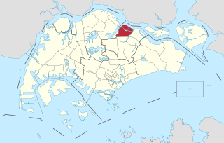
Seletar is an area located in the north-east of Singapore. Its name can also refer to the Seletar Planning Area, situated in the North-East Region of Singapore. The place name was derived from the Malay subgroup who were indigenous to the area, the Orang Seletar. It shares boundaries with the planning areas of Sengkang to the south, Punggol to the east, Yishun and Simpang to the west, as well as the Straits of Johor to the north.

The Central Expressway (CTE) in Singapore is the major highway connecting the city centre of Singapore with the northern residential parts of the island, including Toa Payoh, Bishan and Ang Mo Kio and further onwards to the Seletar Expressway and the Tampines Expressway.

Bedok Reservoir is a reservoir in the eastern part of Singapore, to the north of Bedok. The reservoir has a surface area of 880,000 m2, and a capacity of 12.8 million m3. The mean depth of the reservoir is 9 m, with a maximum depth of 18.2 m. The shoreline length is 4.3 km.
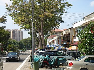
Jalan Kayu is a road situated in Sengkang, Singapore. It is located in the northwestern part of Fernvale, near the Seletar–Sengkang boundary.

Yio Chu Kang, alternatively spelt as Yeo Chu Kang, is a sub-urban area in the northeast of Singapore, with proximity to the Ang Mo Kio, Lentor, Seletar and Sengkang areas. Deriving its name from the Yio Chu Kang Village, it is still known for lush greenery and low-density housing with high-rise public housing in its southern fringes.
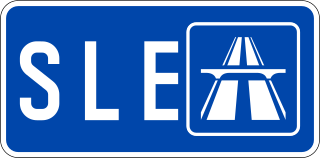
The Seletar Expressway is a highway in Singapore that traverses the northern end of the island and joins the Central Expressway (CTE) and the Tampines Expressway (TPE) in Seletar to the Bukit Timah Expressway (BKE) in Kranji.

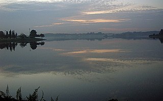
Lower Seletar Reservoir is a reservoir located in the northern part of Singapore in the Lower Seletar subzone, located in Yishun New Town. The reservoir has a surface area of 3.6 km², and a capacity of 9.5 million m³. The mean depth of the reservoir is 2 m, with a maximum depth of 5.5 m. The shoreline length is 14.3 km.

Yishun MRT station is an above-ground Mass Rapid Transit (MRT) station on the North South line (NSL) in Yishun, Singapore. The station is located at the junction of Yishun Avenue 2 and Yishun Avenue 5, and is currently one of the two MRT stations that serve Yishun New Town; the other being Khatib station.

Khatib MRT station is an above-ground Mass Rapid Transit (MRT) station on the North South line (NSL) located in Khatib, Singapore, a subzone in Yishun planning area.

Yio Chu Kang MRT station is an above-ground Mass Rapid Transit (MRT) station on the North South line in Ang Mo Kio, Singapore, near the junction of Ang Mo Kio Avenue 6 and Ang Mo Kio Avenue 8.
Fernvale is a neighbourhood of Sengkang New Town in Singapore. It is located between Sungei Punggol and the proposed Sengkang West Industrial Estate. The house numbers of the public apartment blocks in Fernvale begin with the number '4' (4xx). Fernvale is the newest neighbourhood in Sengkang Town to be completed by the Housing and Development Board (HDB). Seletar Mall, a new shopping amenity which houses Sengkang's first cineplex, is located within this neighbourhood. In 2017, a proposed community facility to be located next to Seletar Mall was announced, which houses a community club, childcare centre, hawker centre and wet market. The community facility which was slated to be ready by the second half of 2020, had stopped construction in April 2020 due to the COVID-19 measures set by the government. Construction of the facility has since continued in the second half of 2020 and was completed in 2022.

Sengkang is a planning area and residential town located in the North-East Region of Singapore. The town is the second most populous in the region, being home to 249,370 residents in 2020. Sengkang shares boundaries with Seletar and Punggol in the north, Pasir Ris and Paya Lebar in the east, Hougang and Serangoon to the south, as well as Yishun and Ang Mo Kio to the west.

Thomson Road is a major trunk road linking Singapore's central business district with the northern suburban areas of the country. The road is one of the longest in Singapore, starting from Novena in the south towards MacRitchie Reservoir, before continuing northwards as Upper Thomson Road towards Yishun and Sembawang.

Yio Chu Kang Bus Interchange is a bus interchange located in Yio Chu Kang, a sub zone of Ang Mo Kio, Singapore. The interchange is located beneath Yio Chu Kang MRT station. Boarding berths are located north of Yio Chu Kang MRT station concourse while and alighting berths are located south.

The Western Water Catchment is a planning area located in the West Region of Singapore. The planning area borders Tuas and Pioneer to its south, Sungei Kadut, Choa Chu Kang and Tengah to its east, Jurong West to its southeast, Lim Chu Kang to its north and the Straits of Johor to its west. It is the largest planning area by land area, covering nearly a tenth of Singapore Island. It is also one of the two main water catchments in Singapore, the other being Central Water Catchment.
Seletar Bus Depot, formerly named Sungei Seletar Bus Depot, is the third bus depot to be built by the Land Transport Authority in Singapore. It is located off Yio Chu Kang Road and houses 29 services under the Seletar Bus Package.

The Bus Contracting Model (BCM), formerly known as the Government Contracting Model, is a contracting model introduced by the Land Transport Authority (LTA) in 2014 for public buses in Singapore, implemented in 2016. The BCM is based on the Transperth model in Perth, Western Australia with quality incentive elements from London Buses. Under the BCM, local and overseas bus operators bid for contracts to operate public bus services on behalf of LTA. The LTA has also adopted a new unified lush green livery and logo for all buses, and now procures and owns the bus fleet for all public bus services in Singapore.
Lower Seletar is a subzone of Yishun, Singapore. It is bounded by Yishun Avenue 1/4 and Yishun Street 41/51 to the north, Seletar Expressway and Seletar West Link to the south, Yishun Avenue 1 to the east and Lentor Avenue to the west.
