Benin, officially the Republic of Benin, and formerly Dahomey, is a country in West Africa. It is bordered by Togo to the west, Nigeria to the east, Burkina Faso to the north-west, and Niger to the north-east. The majority of its population lives on the southern coastline of the Bight of Benin, part of the Gulf of Guinea in the northernmost tropical portion of the Atlantic Ocean. The capital is Porto-Novo, and the seat of government is in Cotonou, the most populous city and economic capital. Benin covers an area of 114,763 square kilometres (44,310 sq mi) and its population in 2021 was estimated to be approximately 13 million. It is a small, tropical country. It is one of the least developed, with an economy heavily dependent on agriculture, and is an exporter of palm oil and cotton. Some employment and income arise from subsistence farming.

Cameroon, officially the Republic of Cameroon, is a country in Central Africa. It shares boundaries with Nigeria to the west and north, Chad to the northeast, the Central African Republic to the east, and Equatorial Guinea, Gabon and the Republic of the Congo to the south. Its coastline lies on the Bight of Biafra, part of the Gulf of Guinea and the Atlantic Ocean. Due to its strategic position at the crossroads between West Africa and Central Africa, it has been categorized as being in both camps. Its nearly 27 million people speak 250 native languages, in addition to the national tongues of English and French, or both.

The Central African Republic (CAR), formerly known as Ubangi-Shari, is a landlocked country in Central Africa. It is bordered by Chad to the north, Sudan to the northeast, South Sudan to the east, the Democratic Republic of the Congo to the south, the Republic of the Congo to the southwest, and Cameroon to the west. Bangui is the country's capital and largest city, at the border with the Democratic Republic of the Congo. The Central African Republic covers a land area of about 620,000 square kilometres (240,000 sq mi). As of 2021, it had an estimated population of around 5.5 million. As of 2024, the Central African Republic is the scene of a civil war, which has been ongoing since 2012.

Guinea, officially the Republic of Guinea, is a coastal country in West Africa. It borders the Atlantic Ocean to the west, Guinea-Bissau to the northwest, Senegal to the north, Mali to the northeast, Cote d'Ivoire to the southeast, and Sierra Leone and Liberia to the south. It is sometimes referred to as Guinea-Conakry after its capital Conakry, to distinguish it from other territories in the eponymous region such as Guinea-Bissau and Equatorial Guinea. Guinea has a population of 14 million and an area of 245,857 square kilometres (94,926 sq mi).

Rwanda, officially the Republic of Rwanda, is a landlocked country in the Great Rift Valley of Central Africa, where the African Great Lakes region and Southeast Africa converge. Located a few degrees south of the Equator, Rwanda is bordered by Uganda, Tanzania, Burundi, and the Democratic Republic of the Congo. It is highly elevated, giving it the soubriquet "land of a thousand hills", with its geography dominated by mountains in the west and savanna to the southeast, with numerous lakes throughout the country. The climate is temperate to subtropical, with two rainy seasons and two dry seasons each year. It is the most densely populated mainland African country; among countries larger than 10,000 km2, it is the fifth most densely populated country in the world. Its capital and largest city is Kigali.

Somalia, officially the Federal Republic of Somalia, is the easternmost country in continental Africa. The country is on the Horn of Africa and is bordered by Ethiopia to the west, Djibouti to the northwest, the Gulf of Aden to the north, the Indian Ocean to the east, and Kenya to the southwest. Somalia has the longest coastline on Africa's mainland. In antiquity, Somalia was an important commercial center. During the Middle Ages, several powerful Somali empires dominated the regional trade, including the Imamate of Awsame, Ajuran Sultanate, the Adal Sultanate, and the Sultanate of the Geledi. In the late 19th century, Somali sultanates were colonized by the Italian and British Empires, who merged all of these tribal territories into two colonies: Italian Somaliland and British Somaliland. In 1960, the two territories united to form the independent Somali Republic under a civilian government. Siad Barre of the Supreme Revolutionary Council (SRC) seized power in 1969 and established the Somali Democratic Republic, brutally attempting to squash the Somaliland War of Independence in the north of the country. The SRC collapsed in 1991 with the onset of the Somali Civil War. The Transitional National Government of Somalia (TNG) was established in 2000, followed by the formation of the Transitional Federal Government of Somalia (TFG) in 2004, which reestablished the Somali Armed Forces.

Tanzania, officially the United Republic of Tanzania, is a country in East Africa within the African Great Lakes region. It borders Uganda to the north; Kenya to the northeast; the Indian Ocean to the east; Mozambique and Malawi to the south; Zambia to the southwest; and Rwanda, Burundi, and the Democratic Republic of the Congo to the west. Mount Kilimanjaro, Africa's highest mountain, is in northeastern Tanzania. According to the 2022 national census, Tanzania has a population of nearly 62 million, making it the most populous country located entirely south of the equator.

Uganda, officially the Republic of Uganda, is a landlocked country in East Africa. The country is bordered to the east by Kenya, to the north by South Sudan, to the west by the Democratic Republic of the Congo, to the south-west by Rwanda, and to the south by Tanzania. The southern part of the country includes a substantial portion of Lake Victoria, shared with Kenya and Tanzania. Uganda is in the African Great Lakes region, lies within the Nile basin, and has a varied but generally modified equatorial climate. As of 2023, it has a population of around 49.6 million, of which 8.5 million live in the capital and largest city of Kampala.

Bangui is the capital and largest city of the Central African Republic. It was established as a French outpost in 1889 and named after its location on the northern bank of the Ubangi River ; the Ubangi itself was named from the Bobangi word for the "rapids" located beside the settlement, which marked the end of navigable water north from Brazzaville. The majority of the population of the Central African Republic lives in the western parts of the country, in Bangui and the surrounding area.
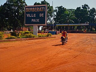
Berbérati is the third-largest city in the Central African Republic, with a population of 105,155. Located in the south-west of the country, near the border with Cameroon, it serves as capital of the Mambéré-Kadéï Prefecture and the Berbérati sub-prefecture.
Ippy is a town located in the Central African Republic prefecture of Ouaka, and is located near the geographic center of the country. It is 364 kilometers from the city of Bangui directly. Driving distance, however, is 496 kilometers.
Akourousoulba or Akoursoulbak is a village in the Bamingui-Bangoran Prefecture in the northern Central African Republic.
Pata, also known as Kpata, is a village in the Bamingui-Bangoran prefecture in the northern Central African Republic.

Yombo Vituka is an administrative ward in the Temeke district of the Dar es Salaam Region of Tanzania. The Kiwalani of Ilala MC forms the ward's northern boundary. Ilala MC's Kipawa and Kitunda are to the west. The ward is bounded to the east by Kilakala and Makangarawe. The ward is bordered with Buza to the south. According to the 2012 census, the ward has a total population of 76,999.

Health in the Central African Republic has been degraded by years of internal conflict and economic turmoil since independence from France in 1960. One sixth of the country's population is in need of acute medical care. Endemic diseases put a high demand on the health infrastructure, which requires outside assistance to sustain itself.

The Central African Republic Civil War is an ongoing civil war in the Central African Republic (CAR) involving the government, rebels from the Séléka coalition, and Anti-balaka militias.

The Anti-balaka is an alliance of militia groups based in the Central African Republic in the early 21st century said to be composed primarily of Christians. However, some church leaders have contested the claimed exclusively Christian character of such groups. The Tony Blair Faith Foundation and journalist Andrew Katz have noted that animists also participate in Anti-balaka groups.

The COVID-19 pandemic in the Central African Republic was a part of the worldwide pandemic of coronavirus disease 2019 caused by severe acute respiratory syndrome coronavirus 2. The COVID-19 pandemic was confirmed to have reached the Central African Republic in March 2020.
Sergobo , also spelled Seregobo, is a village in Vakaga Prefecture, Central African Republic and inhabited by Gula.
Takamala is a village in Vakaga Prefecture, Central African Republic.
