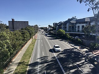
Greenmount junction of Old York Road and Great Eastern Highway
York Road (currently known in parts as the Old York Road) was the main road connecting Guildford and York, in Western Australia, during the 19th and 20th centuries.
Its origins in a talk in 1929 claim an earlier name King Dick Road,[1] and the first settlers usage of the route being on 6 September 1831.[2][3][4]
It became, in the 20th century, portions of the Great Eastern Highway, and the portion of the road traversing the Darling Scarp at Greenmount was named the Old York Road. The re-aligned Great Eastern Highway removed some of the problems of the steep grades along the old alignment.
The road name was also a truncation of the usage of the name Old York-Perth Road.[5] The York Road had convict era sites along its traverse. In the metropolitan area, Chippers Leap, Bilgoman Well, Mahogany Inn (still operating), and other sites have connections with that era, and the remaining original section on Greenmount Hill is still named Old York Road.
↑ "King Dick's Line of Road". Inquirer. No.483. Western Australia. 3 October 1849. p.3. Retrieved 7 February 2021– via National Library of Australia.
↑ "THE YORK ROAD". The West Australian. Vol.XLV, no.8, 485. Western Australia. 30 August 1929. p.16. Retrieved 12 February 2023– via National Library of Australia.
↑ Pelloe, Mrs T. The York Road - read to The Western Australian Historical Society (It was not yet the Royal in 1929) on 25 October 1929, and published in the Journal and Proceedings Vol.1, part VI, pp 1-16
Mundaring Arts Centre (1993) Up the old York Road Mundaring, W.A. Mundaring Arts Centre] (from Battye Library catalogue: - This project was initiated and co-ordinated by the Mundaring Arts Centre. It was a social history based project and involved 15 schools and a number of community groups within the Shire of Mundaring through the financial support supplied by a Department of Community Development Social Advantage Grant.) see http://catalogue.slwa.wa.gov.au/record=b2480392~S2
* Parker, Frank.(2006) The road to York: from Guildford to York Western Australia, an early history York, W.A.: Parker Print. ISBN0-646-45651-2
Smith, Jennifer (1992). Historic watering holes: a report for the National Trust of Australia (W.A.). Stage 2. The Old York Road, from Guildford to York, Western Australia Centre of Prehistory Nedlands, W.A: The University.
Tuckfield, Trevor (197-?) The Old York Road, The Author
John Forrest National Park is a national park in the Darling Scarp, 24 km (15 mi) east of Perth, Western Australia. Proclaimed as a national park in November 1900, it was the first national park in Western Australia and the second in Australia after Royal National Park.
The Darling Scarp, also referred to as the Darling Range or Darling Ranges, is a low escarpment running north–south to the east of the Swan Coastal Plain and Perth, Western Australia. The escarpment extends generally north of Bindoon, to the south of Pemberton. The adjacent Darling Plateau goes easterly to include Mount Bakewell near York and Mount Saddleback near Boddington. It was named after the Governor of New South Wales, Lieutenant-General Ralph Darling.
Great Eastern Highway is a 590-kilometre-long (370 mi) road that links the Western Australian capital of Perth with the city of Kalgoorlie. A key route for road vehicles accessing the eastern Wheatbelt and the Goldfields, it is the western portion of the main road link between Perth and the eastern states of Australia. The highway forms the majority of National Highway 94, although the alignment through the Perth suburbs of Guildford and Midland, and the eastern section between Coolgardie and Kalgoorlie are not included. Various segments form parts of other road routes, including National Route 1, Alternative National Route 94, and State Route 51.
Darlington, Western Australia, is a locality in the Shire of Mundaring on the Darling Scarp, bisected by Nyaania Creek and north of the Helena River.
The Eastern Railway is the main railway route between Fremantle and Northam in Western Australia. It opened in stages between 1881 and 1893. The line continues east to Kalgoorlie as the Eastern Goldfields Railway.
Bellevue is an eastern suburb of Perth, Western Australia in the local government areas of the City of Swan and the Shire of Mundaring. It is at the foot of the slopes of Greenmount, a landmark on the Darling Scarp that is noted in the earliest of travel journals of the early Swan River Colony.
Greenmount is a locality and a geographical feature in the Shire of Mundaring, Western Australia, on the edge of the Darling Scarp. It is a vital point in the transport routes from the Swan Coastal Plain into the hinterland of Western Australia.
The Helena River is a tributary of the Swan River in Western Australia. The river rises in country east of Mount Dale and flows north-west to Mundaring Weir, where it is dammed. It then flows west until it reaches the Darling Scarp.
The Mundaring Branch Railway is a historical section of the original Eastern Railway main line across the Darling Scarp in the Western Australian Government Railways (WAGR) system.
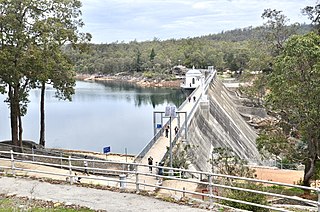
Mundaring Weir is a dam located 39 kilometres (24 mi) from Perth, Western Australia in the Darling Scarp. The dam and reservoir form the boundary between the suburbs of Reservoir and Sawyers Valley. The dam impounds the Helena River.
Blackboy Hill was named after the Australian native "black boy" plants, Xanthorrhoea preissii, which dominated the site which is now absorbed into Greenmount, Western Australia.
Swan View is an eastern suburb of Perth, Western Australia. Its local government areas are the City of Swan and the Shire of Mundaring. It is 25 kilometres (16 mi) from Perth in the Perth Hills on the edge of the Darling Scarp, just to the west of the John Forrest National Park, east of Roe Highway and north of the Great Eastern Highway.
Boya is a locality on the Darling Scarp, in the Shire of Mundaring, Western Australia; it is on the south side of Greenmount Hill, and just west of Darlington.
Mahogany Creek is a suburb of Perth, the state capital of Western Australia. It is part of the Shire of Mundaring local government area.
Chippers Leap, formerly known as Chipper's Leap, is a granite outcrop on Greenmount Hill in Perth, Western Australia. It is located at 31º54'S 116º04'E, on the northern side of Great Eastern Highway, near the border between the suburbs of Swan View and Greenmount.
Perth Hills is a term used primarily for marketing purposes to identify the part of the Darling Scarp and hinterland east of the scarp that lies within the Shire of Mundaring, City of Swan, and the City of Kalamunda and as part of the constituent bodies belonging to the Eastern Metropolitan Regional Council of Perth, Western Australia.
Guildford Road is a major road in Perth, Western Australia, linking the inner-city suburb of Mount Lawley with Guildford in the north-east. The ten-kilometre-long (6.2 mi) road runs mostly parallel to the Swan River, on its northern side, and is part of State Route 51, which runs between Perth's CBD and Midvale. Guildford Road is maintained and controlled by Main Roads Western Australia, which uses the internal designation "H026 Guildford Road" for Guildford Road, as well as Bridge Street and James Street in Guildford. In the 1930s, the name Great Eastern Highway was coined to describe the road, but was actually used for the road on the other side of the Swan River.
Darling Range Hotel was a hotel in Bellevue, Western Australia, on the end of the slope on the Great Eastern Highway at the 'bottom of' Greenmount Hill and just north of the former Bellevue railway station, and over the road from the Helena Vale Racecourse.
The Mundaring Hotel was opened in 1899 in Mundaring, a hills suburb of Perth, Western Australia.
This page is based on this Wikipedia article Text is available under the CC BY-SA 4.0 license; additional terms may apply. Images, videos and audio are available under their respective licenses.