Contents
Yorkshire is a historic county in England.
Yorkshire may also refer to:
Yorkshire is a historic county in England.
Yorkshire may also refer to:

Yorkshire, formally known as the County of York, is a historic county in northern England and by far the largest in the United Kingdom. Because of its large area in comparison with other English counties, functions have been undertaken over time by its subdivisions, which have also been subject to periodic reform. Throughout these changes, Yorkshire has continued to be recognised as a geographic territory and cultural region. The name is familiar and well understood across the United Kingdom and is in common use in the media and the military, and also features in the titles of current areas of civil administration such as North Yorkshire, South Yorkshire, West Yorkshire and the East Riding of Yorkshire.

Lancashire is the name of a historic county, ceremonial county, and non-metropolitan county in North West England. The boundaries of these three areas differ significantly.

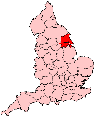
The East Riding of Yorkshire, or simply East Riding or East Yorkshire, is a ceremonial county and unitary authority area in the Yorkshire and the Humber region of England. It borders North Yorkshire to the north and west, South Yorkshire to the south-west, and Lincolnshire to the south.

The historic counties of England are areas that were established for administration by the Normans, in many cases based on earlier kingdoms and shires created by the Angles, Saxons, Jutes, Celts and others. They are alternatively known as ancient counties, traditional counties, former counties or simply as counties. In the centuries that followed their establishment, as well as their administrative function, the counties also helped define local culture and identity. This role continued even after the counties ceased to be used for administration after the creation of administrative counties in 1889, which were themselves amended by further local government reforms in the years following.

The West Riding of Yorkshire is one of three historic subdivisions of Yorkshire, England. From 1889 to 1974 the administrative county County of York, West Riding, abbreviated County of York (WR), was based closely on the historic boundaries. The lieutenancy at that time included the City of York and as such was named West Riding of the County of York and the County of the City of York.
The subdivisions of England constitute a hierarchy of administrative divisions and non-administrative ceremonial areas.
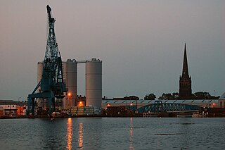
Goole is a port town and civil parish on the River Ouse in the East Riding of Yorkshire, England. The town's historic county is the West Riding of Yorkshire.
Humberside was a non-metropolitan and ceremonial county in Northern England from 1 April 1974 until 1 April 1996. It was composed of land from either side of the Humber Estuary, created from portions of the East Riding of Yorkshire, West Riding of Yorkshire, and the northern part of Lindsey, Lincolnshire. The county council's headquarters was County Hall at Beverley, inherited from East Riding County Council. Its largest settlement and only city was Kingston upon Hull. Other notable towns included Goole, Beverley, Scunthorpe, Grimsby, Cleethorpes and Bridlington. The county stretched from Wold Newton in its northern tip to a different Wold Newton at its most southern point.

The North Riding of Yorkshire is a subdivision of Yorkshire, England, alongside York, the East Riding and West Riding. The riding's highest point is at Mickle Fell with 2,585 ft (788 metres).
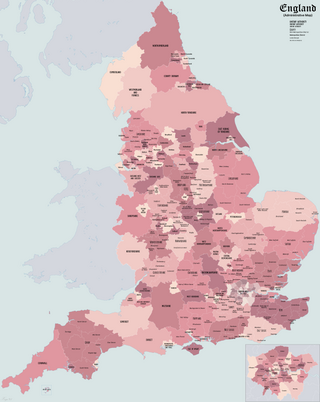
The counties of England are areas used for different purposes, which include administrative, geographical, cultural and political demarcation. The term "county" is defined in several ways and can apply to similar or the same areas used by each of these demarcation structures. These different types of county each have a more formal name but are commonly referred to as just "counties". The current arrangement is the result of incremental reform.

The counties and areas for the purposes of the lieutenancies, also referred to as the lieutenancy areas of England and informally known as ceremonial counties, are areas of England to which lords-lieutenant are appointed. Legally, the areas in England, as well as in Wales and Scotland, are defined by the Lieutenancies Act 1997 as "counties and areas for the purposes of the lieutenancies in Great Britain", in contrast to the areas used for local government. They are also informally known as "geographic counties", to distinguish them from other types of counties of England.

The Parts of Lindsey are a traditional division of Lincolnshire, England, covering the northern part of the county. The Isle of Axholme, which is on the west side of the River Trent, has normally formed part of it. The district's name originated from the Kingdom of Lindsey of Anglo-Saxon times, whose territories were merged with that of Stamford to form Lincolnshire.
The history of local government in Yorkshire is unique and complex. Yorkshire is the largest historic English county and consists of a diverse mix of urban and rural development with a heritage in agriculture, manufacturing, and mining. After a long period with little change, it has been subject to a number of reforms of local government structures in modern times, some of which were controversial. The most significant of these were the Local Government Act 1972, the 1990s UK local government reform, and the Localism Act 2011. The historic area currently corresponds to several counties and districts and is mostly contained within the Yorkshire and the Humber region.

Cleveland was a ceremonial county located in northern England. It was created in 1974 under the Local Government Act 1972, and named after the historic area of Cleveland, Yorkshire. The county was abolished in 1996. The area was partitioned between the four boroughs of Hartlepool, Stockton-on-Tees, Middlesbrough and Langbaurgh-on-Tees, the latter of which took its name from the former Langbaurgh East. The county town was Middlesbrough. The administrative county bordered County Durham to the north and North Yorkshire to the south, and it faced the North Sea to the east. Cleveland had a total area of 225 square miles (583 km2). The legacy of the county lives on in some public bodies, such as Cleveland Police.
Flags and symbols of Yorkshire have been used to identify Yorkshire and its related councils through flags and symbols. This article also includes flags and symbols used by the present and former local authorities covering Yorkshire.
The City of York is a unitary authority of the United Kingdom. There are many distinct localities, suburbs and villages within the administrative area of the City. All areas in the City are in the YO postcode area, also known as the York postcode area.
The East Riding of Yorkshire is a local government district with unitary authority status, and is a ceremonial county of England. It is named after the historic East Riding of Yorkshire which was one of three ridings alongside the North Riding and West Riding, which were constituent parts a Yorkshire ceremonial and administrative county until 1974. From 1974 to 1996 the area of the modern East Riding of Yorkshire constituted the northern part of Humberside.
The United Kingdom and its four constituent countries has a long history of complex administrative geography. Due to the ruling of the country by different ruling classes over the centuries, different parts of the country have different traditional and modern systems of territorial organisation. This article lists different subdivisions found historically and modernly in the different countries of the UK.
The non-metropolitan county of Cleveland was created under the Local Government Act 1972, which came into effect on 1 April 1974, comprising the urban areas around the mouth of the River Tees, previously parts of the administrative counties of Durham and North Riding of Yorkshire. Although it was abolished in 1996, the four unitary authorities which succeeded it have been considered together for the purposes of reviewing parliamentary boundaries. The area has returned 6 MPs to the UK Parliament since 1983.