Young America, Indiana

Last updated
Young America
Young America west from S150E.jpg
Buildings on Roush Street
Map of Indiana highlighting Cass County.svg
Cass County's location in Indiana
Location map of Cass County, Indiana.svg
Red pog.svg
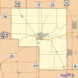
Young America
Location in Cass County
Coordinates: 40°34′07″N86°20′48″W / 40.56861°N 86.34667°W / 40.56861; -86.34667 Coordinates: 40°34′07″N86°20′48″W / 40.56861°N 86.34667°W / 40.56861; -86.34667
Country United States
State Indiana
County Cass
Township Deer Creek
Area
  Total0.4 sq mi (1.1 km2)
Elevation
[1]
764 ft (233 m)
Population
  Total118
Time zone Eastern (EST)
ZIP code
46998
Area code 574
FIPS code 18-86156 [2]
GNIS feature ID 446410

Young America is an unincorporated community in Deer Creek Township, Cass County, Indiana.

Contents

History

Young America was platted about 1856. [3] The town sprang up around a saw mill. When someone wrote "Young America" on the mill's boiler, to indicate the promise of the enterprise, the name stuck. [4]

The Young America post office was established in 1876 and ceased operations in 2019. [5]

Geography

Young America is located at 40°34′07″N86°20′48″W / 40.56861°N 86.34667°W / 40.56861; -86.34667 .

Climate

According to the Köppen Climate Classification system, Young America has a hot-summer humid continental climate, abbreviated "Dfa" on climate maps. The hottest temperature recorded in Young America was 101 °F (38.3 °C) on June 29, 2012, while the coldest temperature recorded was −27 °F (−32.8 °C) on January 19, 1994. [6]

Climate data for Young America, Indiana, 1991–2020 normals, extremes 1992–present
MonthJanFebMarAprMayJunJulAugSepOctNovDecYear
Record high °F (°C)65
(18)
73
(23)
85
(29)
86
(30)
96
(36)
101
(38)
100
(38)
94
(34)
95
(35)
91
(33)
79
(26)
70
(21)
101
(38)
Mean maximum °F (°C)55.1
(12.8)
56.7
(13.7)
70.1
(21.2)
79.8
(26.6)
89.2
(31.8)
89.6
(32.0)
90.8
(32.7)
89.9
(32.2)
90.5
(32.5)
83.4
(28.6)
68.1
(20.1)
58.0
(14.4)
93.8
(34.3)
Average high °F (°C)31.9
(−0.1)
35.9
(2.2)
47.3
(8.5)
60.4
(15.8)
71.8
(22.1)
80.3
(26.8)
82.6
(28.1)
81.2
(27.3)
76.5
(24.7)
64.2
(17.9)
49.1
(9.5)
36.9
(2.7)
59.8
(15.5)
Daily mean °F (°C)24.2
(−4.3)
27.8
(−2.3)
37.9
(3.3)
49.4
(9.7)
61.1
(16.2)
70.0
(21.1)
72.3
(22.4)
70.6
(21.4)
64.3
(17.9)
53.0
(11.7)
40.4
(4.7)
29.9
(−1.2)
50.1
(10.1)
Average low °F (°C)16.5
(−8.6)
19.8
(−6.8)
28.5
(−1.9)
38.4
(3.6)
50.3
(10.2)
59.7
(15.4)
62.0
(16.7)
59.9
(15.5)
52.2
(11.2)
41.8
(5.4)
31.7
(−0.2)
22.8
(−5.1)
40.3
(4.6)
Mean minimum °F (°C)−5.2
(−20.7)
−3.7
(−19.8)
12.4
(−10.9)
25.1
(−3.8)
34.5
(1.4)
46.6
(8.1)
50.7
(10.4)
48.5
(9.2)
39.9
(4.4)
28.7
(−1.8)
7.1
(−13.8)
4.7
(−15.2)
−10.1
(−23.4)
Record low °F (°C)−27
(−33)
−22
(−30)
−9
(−23)
13
(−11)
22
(−6)
35
(2)
42
(6)
40
(4)
31
(−1)
23
(−5)
2
(−17)
−11
(−24)
−27
(−33)
Average precipitation inches (mm)2.52
(64)
2.25
(57)
2.63
(67)
3.64
(92)
3.94
(100)
5.19
(132)
5.14
(131)
3.99
(101)
3.37
(86)
3.08
(78)
3.08
(78)
2.29
(58)
41.12
(1,044)
Average snowfall inches (cm)8.2
(21)
7.3
(19)
2.7
(6.9)
0.6
(1.5)
0.0
(0.0)
0.0
(0.0)
0.0
(0.0)
0.0
(0.0)
0.0
(0.0)
0.0
(0.0)
0.7
(1.8)
5.1
(13)
24.6
(63.2)
Average extreme snow depth inches (mm)6.0
(15)
5.2
(13)
2.6
(6.6)
0.4
(1.0)
0.0
(0.0)
0.0
(0.0)
0.0
(0.0)
0.0
(0.0)
0.0
(0.0)
0.0
(0.0)
0.8
(2.0)
3.5
(8.9)
7.7
(20)
Average precipitation days (≥ 0.01 in)10.69.29.410.910.910.89.48.77.27.98.710.1113.8
Average snowy days (≥ 0.1 in)5.54.82.10.40.00.00.00.00.00.00.53.616.9
Source 1: NOAA [7]
Source 2: National Weather Service (mean maxima/minima 20062020) [6]

Related Research Articles

<span class="mw-page-title-main">Miami County, Indiana</span> County in Indiana, United States

Miami County is a county located in the U.S. state of Indiana. As of 2020, the population was 35,962. The county seat is the City of Peru. Miami County is part of the Kokomo-Peru CSA.

<span class="mw-page-title-main">Howard County, Indiana</span> County in Indiana, United States

Howard County is one of 92 counties in the U.S. state of Indiana. As of the 2020 census, the population was 83,658. The county seat is Kokomo. Originally named Richardville County, it was renamed in 1844 to commemorate General Tilghman Ashurst Howard.

<span class="mw-page-title-main">Cass County, Indiana</span> County in Indiana, United States

Cass County is a county located in the U.S. state of Indiana. As of the 2010 United States Census, its population was 38,966. The county seat is Logansport. Cass County comprises the Logansport, IN Micropolitan Statistical Area.

<span class="mw-page-title-main">Carroll County, Indiana</span> County in Indiana, United States

Carroll County is a county located in the U.S. state of Indiana. As of the 2010 United States Census, the population was 20,155. The county seat is Delphi.

<span class="mw-page-title-main">McNary, Arizona</span> CDP in Apache and Navajo Counties, Arizona

McNary is a census-designated place (CDP) in Apache and Navajo counties in the U.S. state of Arizona, on the Fort Apache Indian Reservation. The population was 528 at the 2010 census. It is a 30-minute drive from Show Low and a 10-minute drive from Pinetop-Lakeside.

<span class="mw-page-title-main">Robinson, Illinois</span> City in Illinois, United States

Robinson is a city in and the county seat of Crawford County, Illinois, United States. The population was 7,150 at the 2020 census, down from 7,713 at the 2010 census.

<span class="mw-page-title-main">Loogootee, Indiana</span> City in Indiana, United States

Loogootee is a city in Perry Township, Martin County, in the U.S. state of Indiana. The population was 2,751 at the time of the 2010 census.

<span class="mw-page-title-main">Woodbury, Tennessee</span> Town in Tennessee, United States

Woodbury is a town in Cannon County, Tennessee, United States. Woodbury is part of the Nashville Metropolitan Statistical Area and is located 55 miles (89 km) southeast of downtown Nashville. The population of Woodbury was 2,680 at the 2010 census. It is the county seat of Cannon County.

<span class="mw-page-title-main">Clymers, Indiana</span> Unincorporated community in Indiana, United States

Clymers is an unincorporated community in Clinton Township, Cass County, Indiana.

<span class="mw-page-title-main">Mount Pleasant, Cass County, Indiana</span> Unincorporated community in Indiana, United States

Mount Pleasant is a nearly extinct unincorporated town in Bethlehem Township, Cass County, Indiana.

<span class="mw-page-title-main">Converse, Blackford County, Indiana</span> Unincorporated community in Indiana, United States

Converse is an unincorporated community in Jackson Township, Blackford County, in the U.S. state of Indiana. Although not much of the community remains, the U.S. Geological Survey considers it a populated place. The community existed as a "flag" station along a railroad, and is named after railroad executive Joel N. Converse. Like many communities in Blackford County, this village declined after the end of the Indiana Gas Boom, which ended in the early 20th century.

<span class="mw-page-title-main">Adamsboro, Indiana</span> Unincorporated community in Indiana, United States

Adamsboro is an unincorporated community in Clay Township, Cass County, Indiana.

<span class="mw-page-title-main">Anoka, Indiana</span> Unincorporated community in Indiana, United States

Anoka is an unincorporated community in Washington Township, Cass County, Indiana.

<span class="mw-page-title-main">Georgetown, Cass County, Indiana</span> Unincorporated community in Indiana, United States

Georgetown is an unincorporated community in Jefferson Township, Cass County, Indiana.

<span class="mw-page-title-main">Hoover, Indiana</span> Unincorporated community in Indiana, United States

Hoover is an unincorporated community in Adams Township, Cass County, Indiana. As of June 2022 Hoover has an approximate population of 35 residents.

<span class="mw-page-title-main">Lincoln, Indiana</span> Unincorporated community in Indiana, United States

Lincoln is an unincorporated community in Jackson Township, Cass County, Indiana.

<span class="mw-page-title-main">Lucerne, Indiana</span> Unincorporated community in Indiana, United States

Lucerne is an unincorporated community in Harrison Township, Cass County, Indiana.

<span class="mw-page-title-main">New Waverly, Indiana</span> Unincorporated community in Indiana, United States

New Waverly is an unincorporated community in Miami Township, Cass County, Indiana.

<span class="mw-page-title-main">New Corydon, Indiana</span> Unincorporated community in Indiana, United States

New Corydon is an unincorporated community in Wabash Township, Jay County, Indiana.

<span class="mw-page-title-main">Fayetteville, Indiana</span> Unincorporated community in Indiana, United States

Fayetteville is an unincorporated community in Indian Creek Township, Lawrence County, in the U.S. state of Indiana.

References

  1. "US Board on Geographic Names". United States Geological Survey. 2007-10-25. Retrieved 2008-01-31.
  2. "U.S. Census website". United States Census Bureau . Retrieved 2008-01-31.
  3. Helm, Thomas B. (1878). History of Cass County, Indiana. Kingman Bros. pp.  41.
  4. Powell, Jehu Z. (1913). History of Cass County Indiana: From Its Earliest Settlement to the Present Time. Lewis Publishing Company. pp.  568.
  5. "Cass County". Jim Forte Postal History. Retrieved 29 August 2014.
  6. 1 2 "NOAA Online Weather Data – NWS Northern Indiana". National Weather Service. Retrieved February 5, 2023.
  7. "U.S. Climate Normals Quick Access – Station: Young America, IN". National Oceanic and Atmospheric Administration. Retrieved February 5, 2023.