
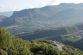
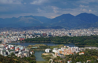
Tirana is the capital and largest city of Albania. It is located in the centre of the country, enclosed by mountains and hills with Dajti rising to the east and a slight valley to the northwest overlooking the Adriatic Sea in the distance. Due to its location at the Plain of Tirana and the close proximity to the Mediterranean Sea, the city is particularly influenced by a Mediterranean seasonal climate. It is among the wettest and sunniest cities in Europe, with 2,544 hours of sun per year.
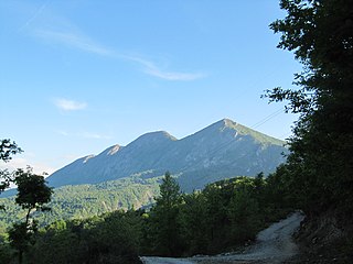
Dajti standing at 1,613 m (5,292 ft) above sea level, is a mountain and national park on the edge of Tirana, Albania. The Dajti belongs to the Skanderbeg range. In winter, the mountain is often covered with snow and is a popular retreat for the local population of Tirana, which rarely sees snowfall. Its slopes have forests of pines, oak and beech, while its interior contains canyons, waterfalls, caves, a lake, and an ancient castle.

Tirana County, officially the County of Tirana, is a county in the Central Region of the Republic of Albania. It is the tenth largest by area and the most populous of the twelve counties, with more than 912,000 people within an area of 1,652 km2 (638 sq mi). The county borders on the Adriatic Sea to the west, the counties of Durrës to the northwest, Dibër to the northeast, Elbasan to the east and Fier to the southwest. It is divided into five municipalities, Tirana, Kamëz, Kavajë, Rrogozhinë and Vorë, with all of whom incorporate twenty-nine administrative units.
Ndroq is a village and a former municipality near Tirana, the capital of Albania. It is part of Tirana County. At the 2015 local government reform it became a subdivision of the municipality Tirana. The population at 2011 census was 5,035.
Mullet is a village in Tirana County, Albania. At the 2015 local government reform it became part of the municipality Tirana. It lies at an elevation of 551 feet.

Vorë is a municipality in Tirana County, central Albania. It was formed at the 2015 local government reform by the merger of the former municipalities Bërxullë, Prezë and Vorë, that became municipal units. The seat of the municipality is the town Vorë. The total population is 25,511, in a total area of 82.76 km2. The population of the former municipality at the 2011 census was 10,901.
Krrabë is a town and a former municipality in the Tirana County, central Albania. At the 2015 local government reform it became a subdivision of the municipality Tirana. The population at the 2011 census was 2,343.
Dajt is a former municipality in the Tirana County, central Albania. At the 2015 local government reform it became a subdivision of the municipality Tirana. The population at the 2011 census was 20,139. The municipal unit took its name from the Mount Dajt.
Zall-Herr is a village and administrative unit in the municipality of Tirana, central Albania. As of the 2011 census, the administrative unit of Zall-Herr had an estimated population of 9,389 of whom 4,830 were men and 4,559 women.
Kashar is a village and a former municipality in the Tirana County, central Albania. The population at the 2011 census was 43,353.
Vaqarr is a village and administrative unit in the municipality of Tirana, central Albania. As of the 2011 census, the administrative unit of Vaqarr had an estimated population of 9,106 of whom 4,838 were men and 4,268 women. The Lake of Vaqarr has become a popular recreation area in the municipality of Tirana.
Farkë is a former municipality in the Tirana County, central Albania. At the 2015 local government reform it became a subdivision of the municipality Tirana. The population at the 2011 census was 22,633.
Pezë is a former municipality in the Tirana County, central Albania. At the 2015 local government reform it became a subdivision of the municipality Tirana. The population at the 2011 census was 6,272. Peza was the headquarters of the National Liberation Movement of Albania.
The Grand Park of Tirana, or the Park on the Artificial Lake, is a 289 hectare public park situated on the southern part of Tirana, Albania, and administered by the Agency of Parks and Recreation of the Municipality of Tirana.

The Tanners' Bridge is an 18th-century Ottoman period stone footbridge located in Tirana, Albania. The bridge, built near the Tanners' Mosque, was once part of the Saint George Road that linked Tirana with the eastern highlands. The road was the rout by which livestock and produce entered the city. The bridge crossed the Lanë stream near the area where butcher shops and leather workers were located. The bridge fell into disrepair when the Lanë was diverted in the 1930s. In the 1990s the bridge was restored for use by pedestrians.

The Kapllan Pasha Tomb is a Muslim Türbe of Albania, located in the center of Tirana. It is a Cultural Monument of the first category and was so declared by the government of Albania in 1948. It was built in the early 19th century, with carved stones and has an octagonal shape. The columns are made of stone, and placed also on stone bases and capitals with plant decor on the surface. The former ruler of Tirana was interned here in the 19th century, but was later repatriated back to Istanbul, Turkey.

Vrap is a village in the former municipality of Baldushk in Tirana County, Albania. At the 2015 local government reform it became part of the municipality Tirana.
Selitë is a neighborhood of Tirana in the former municipality of Farkë in Tirana County, Albania. At the 2015 local government reform it became part of the municipality Tirana.
Katundi i Ri is a village in the former municipality of Kashar in Tirana County, Albania. At the 2015 local government reform it became part of the municipality Tirana.
Dritas is a village in the former municipality of Zall-Herr in Tirana County, Albania. At the 2015 local government reform it became part of the municipality Tirana.

