Ghana is a West African country in Africa, along the Gulf of Guinea.

Margaret River is a town in the South West of Western Australia, located in the valley of the eponymous Margaret River, 277 kilometres (172 mi) south of Perth, the state capital. Its Local Government Area is the Shire of Augusta-Margaret River.

With an area of 238,397 km2 (92,046 sq mi), Romania is the twelfth-largest country in Europe. Located in Central and Southeastern Europe, bordering on the Black Sea, the country is halfway between the equator and the North Pole and equidistant from the westernmost part of Europe—the Atlantic Coast—and the most easterly—the Ural Mountains. Romania has 3,195 kilometres (1,985 mi) of border. Republic of Moldova and Ukraine lie to the east, Bulgaria lies to the south, and Serbia and Hungary to the west. In the southeast, 245 kilometres (152 mi) of sea coastline provide an important outlet to the Black Sea and the Atlantic Ocean.

Chiang Rai is the northernmost major city in Thailand, with a population of about 200,000 people. It is located in Mueang Chiang Rai District, Chiang Rai Province. Chiang Rai was established as a capital city in the reign of King Mangrai, in 1262 CE.

The Yamuna, also spelt Jamuna, is the second-largest tributary river of the Ganges by discharge and the longest tributary in India. Originating from the Yamunotri Glacier at a height of about 4,500 m (14,800 ft) on the southwestern slopes of Bandarpunch peaks of the Lower Himalaya in Uttarakhand, it travels a total length of 1,376 kilometres (855 mi) and has a drainage system of 366,223 square kilometres (141,399 sq mi), 40.2% of the entire Ganges Basin. It merges with the Ganges at Triveni Sangam, Allahabad, which is a site of the Kumbh Mela, a Hindu festival held every 12 years.

The Kolyma is a river in northeastern Siberia, whose basin covers parts of the Sakha Republic, Chukotka Autonomous Okrug, and Magadan Oblast of Russia.
The province of Oristano is a province in the autonomous island region of Sardinia in Italy. Its capital is the city of Oristano. It has an area of 3,040 square kilometres (1,170 sq mi), a total population of 160,746 (2016), and a population density of 53.7 people per square kilometer. There are 87 municipalities (comuni) in the province).

Bhavani is a Municipality in Erode District, Tamil Nadu, India. It is located at the northern periphery of Erode City Municipal Corporation and is around 105 km (65 mi) from Coimbatore and 60 km (37 mi) from Tiruppur and Salem. Bhavani is also known as "Carpet City" as it is known for its carpet industry; blankets and carpets manufactured in the town are known as Bhavani Jamakkalam. As of 2011, the town covers an area of 2.17 square kilometres (0.84 sq mi) and has a population of 39,225. It is a grade II municipality.
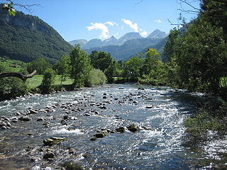
Thur is a 131-kilometre-long (81 mi) river in north-eastern Switzerland. Its source is near the mountain Säntis in the south-east of the canton of St. Gallen. In this canton it flows through the Toggenburg region and the town of Wil, SG. After Wil, the Thur flows through the canton of Thurgau, named after the river, and its capital Frauenfeld. The final 19 kilometres (12 mi) of the Thur are in the canton of Zürich. It then flows into the river Rhine on the border with Germany, south of Schaffhausen.

Batken Region is a region (oblus) of Kyrgyzstan. Its capital is Batken. It is bounded on the east by Osh Region, on the south, west and north by Tajikistan, and on the northeast by Uzbekistan. The northern part of the region is part of the flat, agricultural Ferghana Valley. The land rises southward to the mountains on the southern border: the Alay Mountains in the east, and the Turkestan Range in the west. Its total area is 17,048 km2 (6,582 sq mi). The resident population of the region was 548,247 as of January 2021. The region has sizeable Uzbek and Tajik minorities.

The Brahmani is a major seasonal river in the Odisha state of eastern India. The Brahmani is formed by the confluence of the Sankh and South Koel rivers, and flows through the districts of Sundargarh, Deogarh, Angul, Dhenkanal, Cuttack, Jajapur and Kendrapara. Together with the river Baitarani, it forms a large delta before emptying into the Bay of Bengal at Dhamra. It is the second widest river in Odisha after Mahanadi.
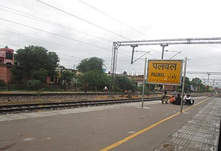
Palwal is a city and a municipal council. It is the headquarters of Palwal district, the 21st district of Haryana state in northern India. It is a centre of the cotton trade in the area. It is also a part of National Capital Region.

The Tagliamento is a braided river in north-east Italy, flowing from the Alps to the Adriatic Sea at a point between Trieste and Venice.

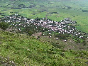
Korem is a town and separate woreda in Tigray, Ethiopia. Located on the eastern edge of the Ethiopian highlands in the Debubawi (Southern) Zone of the Tigray Region, this town has a latitude and longitude of 12°30′N39°31′E with an elevation of 2539 meters above sea level and is located along Ethiopian Highway 2. Korem is located in the endoreic basin of the Afar Triangle. The streams near Korem do not reach the ocean. Lake Ashenge is located six kilometers to the north of Korem. The town of Korem is surrounded by Ofla woreda.

Ofla is one of the Districts of Ethiopia, or woredas, in the Tigray Region of Ethiopia. Part of the Debubawi Zone, Ofla is bordered on the south by Alamata, on the west by the Amhara Region, on the north by Endamehoni, and on the east by Raya Azebo. Small towns in Ofla include Sesela and Zikuya. The town of Korem is surrounded by Ofla woreda.
SekotaZuria is one of the woredas in the Amhara Region of Ethiopia. Located in the Wag Hemra Zone, Sekota is bordered on the south by Gazbibla, on the southwest by Dehana, on the west by Zikuala, on the north by Abergele, and on the east by the Tigray Region. The separate woreda of town of Soqota is surrounded by Sekota. Abergele woreda was separated from Sekota.

The River Nagavali also known as Langulya is one of the main rivers of Southern Odisha and North Andhra States in India, between Rushikulya and Godavari basins.
The Little Black River is a river flowing in the south of Quebec (Canada) and in the north of Maine.

The St Austell River properly known as the River Vinnick, but historically called The White River, is a 12 kilometres (7.5 mi) long river located in south Cornwall, England, United Kingdom. 50.337°N 4.793°W. The river has also been known as the "red river" due to tin streaming and mining activity upstream.
Delanta is one of the woredas in the Amhara Region of Ethiopia. Dälanta wäräda is located in the Amhara National Regional State of South Wällo Zone and pinned on 38⁰ 40’ 39” north and 11⁰ 20’ 11” east. One among 24 wäräda’s in the South Wällo Zone administration, Dälanta is touched between Wadla and Gubalafto wärädas to its north; Dawənt wäräda to its west; Tänta wäräda to its south; and Ambassäl to its east. Dälanta’s administrative center, Wägäl Țena, is 98 kilometers away from the zonal capital Däse town and 499 kilometers from the nation’s capital Addis Ababa. Wägäl Țena was established in 1891 during the zenith reign of Ras Wäle Bəțul- brother of Empress Țaytu. He was ruling Dälanta, Wadla, Dawunt, Mäqet and Yäğğu wärädas at his capital in Märțo town in Yäğğu, where his son Däğğazmać Amäde Wäle is recognized for its status as a political ownership. Successive descendants of Bəțul, a very powerful Yäğğu dynasty, had ruled Wadla and Dälanta; thus started the era of “Wadla Dälanta” axiom.[1]