| Završje | |
|---|---|
 | |
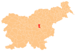
 Završje Location in Slovenia | |
| Coordinates: 46°6′22.84″N15°1′33.41″E / 46.1063444°N 15.0259472°E Coordinates: 46°6′22.84″N15°1′33.41″E / 46.1063444°N 15.0259472°E | |
| Country | |
| Traditional region | Lower Carniola |
| Statistical region | Central Sava |
| Municipality | Trbovlje |
| Area | |
| • Total | 6.18 km2 (2.39 sq mi) |
| Elevation | 708.3 m (2,323.8 ft) |
| Population (2002) | |
| • Total | 51 |
| [1] | |
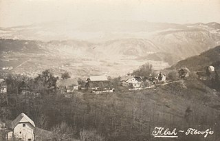
Završje (pronounced [ˈzaːʋəɾʃjɛ] ) is a dispersed settlement in the Municipality of Trbovlje in central Slovenia. It lies in the hills south of the right bank of the Sava River. Traditionally the area was part of the Lower Carniola region. It is now included with the rest of the municipality in the Central Sava Statistical Region. [2]

A municipality is usually a single urban administrative division having corporate status and powers of self-government or jurisdiction as granted by national and regional laws to which it is subordinate. It is to be distinguished (usually) from the county, which may encompass rural territory or numerous small communities such as towns, villages and hamlets.

Trbovlje is Slovenia's ninth largest town, and the seat of the Municipality of Trbovlje. It is located in the valley of a minor left bank tributary of the Sava River in the Central Sava Valley in central-eastern Slovenia.

Slovenia, officially the Republic of Slovenia, is a sovereign state located in southern Central Europe at a crossroads of important European cultural and trade routes. It is bordered by Italy to the west, Austria to the north, Hungary to the northeast, Croatia to the southeast, and the Adriatic Sea to the southwest. It covers 20,273 square kilometers (7,827 sq mi) and has a population of 2.07 million. One of the successor states of the former Yugoslavia, Slovenia is a parliamentary republic and a member of the United Nations, of the European Union, and of NATO. The capital and largest city is Ljubljana.
The local church is dedicated to Saint Michael and belongs to the Parish of Dobovec. It dates to the 17th century. [3]

A church building or church house, often simply called a church, is a building used for Christian religious activities, particularly for Christian worship services. The term is often used by Christians to refer to the physical buildings where they worship, but it is sometimes used to refer to buildings of other religions. In traditional Christian architecture, the church is often arranged in the shape of a Christian cross. When viewed from plan view the longest part of a cross is represented by the aisle and the junction of the cross is located at the altar area.

Saint Michael the Archangel is an archangel in Judaism, Christianity, and Islam. In Roman Catholic, Eastern Orthodox, Anglican, and Lutheran traditions, he is called "Saint Michael the Archangel" and "Saint Michael". In the Oriental Orthodox and Eastern Orthodox religions, he is called "Saint Michael the Taxiarch".
A parish is a territorial entity in many Christian denominations, constituting a division within a diocese. A parish is under the pastoral care and clerical jurisdiction of a parish priest, who might be assisted by one or more curates, and who operates from a parish church. Historically, a parish often covered the same geographical area as a manor. Its association with the parish church remains paramount.