Related Research Articles

Nootka Island is an island adjacent to Vancouver Island in British Columbia, Canada. It is 510 square kilometres (200 sq mi) in area. It is separated from Vancouver Island by Nootka Sound and its side-inlets, and is located within Electoral Area A of the Strathcona Regional District.

The Regional District of Comox-Strathcona was a regional district of British Columbia, Canada from 1967 to 2008. On February 15, 2008, the regional district was abolished and replaced by two successor regional districts, Comox Valley and Strathcona.
Tahsis is a village municipality on the west coast of Vancouver Island, British Columbia, Canada, about 300 km (186 mi) northwest of the provincial capital Victoria at 49°55′33″N126°37′16″W. As of 2011, the Canadian census listed 316 residents, a decline from the 2006 Census count of 366 residents. The Village of Tahsis economy used to be dependent on forestry, but after the closure of the local sawmill in 2001, the economy became heavily dependent on sport fishing for salmon and halibut, outdoor recreation and tourism.

Jervis Inlet is one of the principal inlets of the British Columbia Coast, about 95 km (59 mi) northwest of Vancouver, and the third of such inlets north of the 49th parallel, the first of which is Burrard Inlet, Vancouver's harbour.

Knight Inlet is one of the principal inlets of the British Columbia Coast, and the largest of the major inlets in the southern part of the Coast. It is fifth in sequence of the great saltwater inlets north from the 49th parallel near Vancouver, but it is the first whose outflow points away from the Strait of Georgia, opening into Queen Charlotte Strait at the Kwakwakaʼwakw community of Memkumlis on Village Island.
Kingcome Inlet is one of the lesser principal fjords of the British Columbia Coast, north and east of Broughton Island. It is sixth in sequence of the major saltwater fjords north from the 49th parallel near Vancouver and similar in width, on average 2.5 km (1.6 mi), to longer inlets such as Knight Inlet and Bute Inlet, but it is only 35 km (22 mi) in length from the mouth of the Kingcome River to Sutlej Channel, which ultimately connects around Broughton Island to the main regional waterway of the Queen Charlotte Strait. Kingcome Inlet has a short side inlet, Wakeman Sound, fed by the Wakeman River.
Catala Island Marine Provincial Park is a provincial park in British Columbia, Canada, located on the west coast of Vancouver Island at the mouth of Esperanza Inlet, between Kyuquot Sound (N) and Nootka Sound (S). The park is 955 ha. in size and was established in July 1995.
Gold Muchalat Provincial Park is a provincial park in British Columbia, Canada, located between the Gold and Muchalat Rivers.

Nuchatlitz Provincial Park is a provincial park in British Columbia, Canada, located no the northwest side of Nootka Island, facing Nuchatlitz Inlet, on the west coast of Vancouver Island. Established in 1996, the park contains approximately 2105 ha.
Zeballos is a village located on the northwest coast of Vancouver Island in British Columbia, Canada. Zeballos is now known for its ecotourism and sport fishing.

Indian Arm is a steep-sided glacial fjord adjacent to the city of Vancouver in southwestern British Columbia. Formed during the last Ice Age, it extends due north from Burrard Inlet, between the communities of Belcarra and the District of North Vancouver, then on into mountainous wilderness. Burrard Inlet and the opening of Indian Arm was mapped by Captain George Vancouver and fully explored days later by Dionisio Alcalá Galiano in June 1792.

The Vancouver Island Ranges, formerly called the Vancouver Island Mountains, are a series of mountain ranges extending along the length of Vancouver Island which has an area of 31,788 km2 (12,273 sq mi). The Vancouver Island Ranges comprise the central and largest part of the island. The Geological Survey of Canada refers to Vancouver Island, Haida Gwaii, and the Alaska Panhandle as the Insular Belt including the sea floor out to 100 km (62 mi) west of Vancouver Island. The Vancouver Island Ranges are a sub-range of the Insular Mountains.

The Gwa'Sala-Nakwaxda'xw Nations are a union of two Kwakwaka'wakw peoples in a band government based on northern Vancouver Island in British Columbia, Canada, whose main reserve community is near the town of Port Hardy in the Queen Charlotte Strait region of the Central Coast region of British Columbia, Canada. The band government is a member of the Kwakiutl District Council and, for treaty negotiation purposes, the Winalagalis Treaty Group which includes three other members of the Kwakiutl District Council.
Ḵwiḵwa̱sut'inux̱w Ha̱xwa'mis, formerly the Kwicksutaineuk-ah-kwa-mish First Nation is a First Nations band government based on northern Vancouver Island in British Columbia, Canada, in the Queen Charlotte Strait region. It is a member of the Musgamagw Tsawataineuk Tribal Council, along with the ‘Namgis First Nation and the Tsawataineuk First Nation. The Kwikwasut'inuxw and Haxwa'mis are two of the many subgroups of the peoples known as Kwakwaka'wakw, which means "speakers of Kwak'wala", their language, and were combined into one band by the Department of Indian and Northern Affairs.
Franklin River in Vancouver Island, British Columbia, is located between Alberni Inlet and Barkley Sound, was named as part of the Vancouver Island Exploration Expedition of 1864. The river was named for Selim Franklin, Esquire, who was Chairman of the Exploration Committee.
The Tlowitsis Nation, formerly the Klowitsis Tribe, the Turnour Island Band and the Tlowitsis-Mumtagila First Nation, is the Indian Act band government of the Ławit'sis (Tlowitsis) tribe of the Kwakwaka'wakw peoples, located in the Queen Charlotte Strait-Johnstone Strait area in the Discovery Islands between Vancouver Island and the British Columbia mainland in Canada. Ławit'sis territory covers parts of northern Vancouver Island, Johnstone Strait, and adjoining inlets of the mainland. Kalugwis, on Turnour Island, was their principal community in times past, but the band's offices are in the city of Campbell River to the southeast. Hanatsa IR No. 6 on Port Neville is the most populated of the band's Indian reserves.
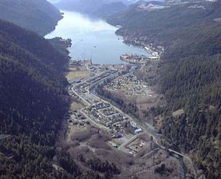
Zeballos Inlet is an extension of Esperanza Inlet in the North Island region of Vancouver Island, Canada. Though inland relative to the outer coast, it is part of the Pacific Ocean as are other inlets on the west coast of Vancouver Island. At the head of the inlet are the Zeballos River and the village municipality of Zeballos, which was founded as a gold-mining town.
Esperanza Inlet is an inlet on the West Coast of Vancouver Island in British Columbia, Canada. Its entrance is located off the northwest side of Nootka Island and is defined by a line drawn from Tachu Point to Blind Reef. Until that definition was applied by the Canadian Hydrographic Service in 1959, the inlet's entrance was considered to be the area southeast of Catala Island. Among its adjoining branches is Zeballos Inlet.
Tribune Channel is a channel or strait on the Central Coast of British Columbia, Canada, separating Gilford Island on the west and north from the mainland. The channel bends around Gilford Island, with the mouth of Thompson Sound at the elbow of the bend, opening eastwards to the mouth of the Kakweiken River.
Drury inlet is an inlet in the Queen Charlotte Strait region of the Central Coast of British Columbia, Canada, extending west from Wells Passage to the northwest of North Broughton Island, northwest of the town of Port Hardy. Branching off to the northeast from the north side of the head of the inlet is Actaeon Sound.
References
- ↑ "Zeballos River". BC Geographical Names .
- ↑ BC Names/GeoBC entry "Zeballos Inlet"
- ↑ N.L. Barlee (1980), The Guide to Gold Panning, Revised Second Edition, Second Printing. Canada West Publications., ISBN 0-920164-04-8