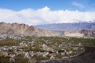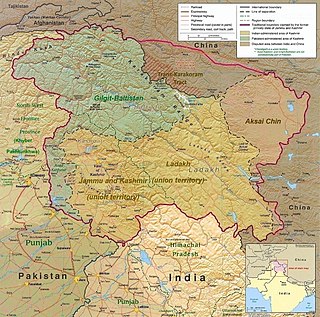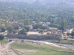
Leh is a city in Ladakh in the Kashmir Kashmir region. It is the largest city and the joint capital of Ladakh. Leh, located in the Leh district, was also the historical capital of the Kingdom of Ladakh. The seat of the kingdom, Leh Palace, the former residence of the royal family of Ladakh, was built in the same style and about the same time as the Potala Palace in Tibet. Since they were both constructed in a similar style and at roughly the same time, the Potala Palace in Tibet and Leh Palace, the royal residence, are frequently contrasted. Leh is at an altitude of 3,524 m (11,562 ft), and is connected via National Highway 1 to Srinagar in the southwest and to Manali in the south via the Leh-Manali Highway.

Kargil district is a district in Indian-administered Ladakh in the disputed Kashmir-region. It is one of the two districts comprising the Indian-administered union territory of Ladakh. The district headquarters are in the city of Kargil. The district is bounded by the Indian-administered union territory of Jammu and Kashmir to the west, the Pakistani-administered administrative territory of Gilgit–Baltistan to the north, Ladakh's Leh district to the east, and the Indian state of Himachal Pradesh to the south. Encompassing three historical regions known as Purig, Dras and Zanskar, the district lies to the northeast of the Great Himalayas and encompasses the majority of the Zanskar Range. Its population inhabits the river valleys of the Dras, Suru, Wakha Rong, and Zanskar.

Skardu is a city located in Pakistan-administered Gilgit-Baltistan in the disputed Kashmir region. Skardu serves as the capital of Skardu District and the Baltistan Division. It is situated at an average elevation of nearly 2,500 metres above sea level in the Skardu Valley, at the confluence of the Indus and Shigar rivers. The city is an important gateway to the eight-thousanders of the nearby Karakoram mountain range. The Indus River running through the region separates the Karakoram from the Ladakh Range.

Leh district is a district in Indian-administered Ladakh in the disputed Kashmir-region. Ladakh is an Indian-administered union territory. With an area of 45,110 km2, it is the second largest district in the country, second only to Kutch. It is bounded on the north by Gilgit-Baltistan's Kharmang and Ghanche districts and Xinjiang's Kashgar Prefecture and Hotan Prefecture, to which it connects via the historic Karakoram Pass. Aksai Chin and Tibet are to the east, Kargil district to the west, and Lahul and Spiti to the south. The district headquarters is in Leh. It lies between 32 and 36 degree north latitude and 75 to 80 degree east longitude.

Kargil or Kargyil is a city in Indian-administered Ladakh in the disputed Kashmir region. It is the joint capital of Ladakh, an Indian-administered union territory. It is also the headquarters of the Kargil district. It is the second-largest city in Ladakh after Leh. Kargil is located 204 kilometres (127 mi) east of Srinagar in Jammu and Kashmir, and 234 kilometres (145 mi) to the west of Leh. It is on the bank of the Suru River near its confluence with the Wakha Rong river, the latter providing the most accessible route to Leh.

Ladakh has a long history with evidence of human settlement from as back as 9000 b.c. It has been a crossroad of high Asia for thousands of years and has seen many cultures, empires and technologies born in its neighbours. As a result of these developments Ladakh has imported many traditions and culture from its neighbours and combining them all gave rise to a unique tradition and culture of its own.

Tourism is one of the economic contributors to the union territory of Ladakh in Northern India. The union territory is sandwiched between the Karakoram mountain range to the north and the Himalayas to the south, and is situated at a height of 11,400 ft. Ladakh is composed of Leh and Kargil districts. The region contains prominent Buddhist sites and has an ecotourism industry.

Zorawar Singh was a military general of the Dogra Rajput ruler, Gulab Singh of Jammu. He served as the governor (wazir-e-wazarat) of Kishtwar and extended the territories of the kingdom by conquering Ladakh and Baltistan. He also boldly attempted the conquest of Western Tibet but was killed in battle of To-yo during the Dogra-Tibetan war. In reference to his legacy of conquests in the Himalaya Mountains including Ladakh, Tibet, Baltistan and Skardu as General and Wazir, Zorowar Singh has been referred to as the "Napoleon of India", and "Conqueror of Ladakh".

The Namgyal dynasty was a dynasty whose rulers were the monarchs of the former kingdom of Ladakh that lasted from 1460 to 1842 and were titled the Gyalpo of Ladakh. The Namgyal dynasty succeeded the first dynasty of Maryul and had several conflicts with the neighboring Mughal Empire and various dynasties of Tibet, including the Tibet–Ladakh–Mughal War. The dynasty eventually fell to the Sikh Empire and Dogras of Jammu. Most of its known history is written in the Ladakh Chronicles.

The Leh–Manali Highway is a 428 km (266 mi) long highway in northernmost India connecting Leh, the capital of the Union Territory of Ladakh, to Manali in the state of Himachal Pradesh. It crosses four passes Rohtang la, Baralacha la, lungalacha la, tanglang la. It connects the Kullu Valley of the upper Beas river to the Chandra and Bhaga river valleys of Lahaul via the Atal tunnel in Himachal Pradesh, then crosses over a series of high Himalayan passes into the Indus river valley in Ladakh. It is usually open for about six months a year from the first week of May when the snow is cleared from the highway to October when snowfall again blocks the high passes on the highway. Before the construction of the Atal tunnel, the highway used to remain closed beyond the Rohtang Pass during winter. With the completion of the proposed Shingo La Tunnel on an alternate route through Zanskar valley, targeted to be completed by 2025, the whole Leh-Manali route will become an all-weather road.

Upshi is a village and road junction on the Leh-Manali Highway in the union territory of Ladakh in India. It is located 47 km (29 mi) to the southeast of Leh along the Indus river valley and Tanglang La on the Leh-Manali highway. Gya is also to the south.

National Highway 1D, also known as Srinagar–Leh Highway, was a National Highway in the state of Jammu and Kashmir that connected Srinagar to Leh in Ladakh. The Srinagar-Leh Highway was declared as National Highway in 2006. It is now part of National Highway 1 that extends west to Uri.
The Dogra–Tibetan war or Sino-Sikh war was fought from May 1841 to August 1842, between the forces of the Dogra nobleman Gulab Singh of Jammu, under the suzerainty of the Sikh Empire, and those of Tibet, under the protectorate of the Qing dynasty. Gulab Singh's commander was the able general Zorawar Singh Kahluria, who, after the conquest of Ladakh, attempted to extend its boundaries in order to control the trade routes into Ladakh. Zorawar Singh's campaign, suffering from the effects of inclement weather, suffered a defeat at Taklakot (Purang) and Singh was killed. The Tibetans then advanced on Ladakh. Gulab Singh sent reinforcements under the command of his nephew Jawahir Singh. A subsequent battle near Chushul in 1842 led to a Tibetan defeat. A treaty was signed in 1842 maintaining the status quo ante bellum.

The Bhanupli–Leh line is an under-construction electrified railway track connecting Bhanupli, Punjab, to Leh, Ladakh. Once complete, the 489 km (304 mi) long, 1,676 mm wide gauge all-weather track is stipulated to reduce travel time from New Delhi to Leh to 10 hours. The railway is to pass through seismic zone IV and V at an elevation of 600 m (2,000 ft) to 5,360 m (17,590 ft) above sea level.

National Highway 1 in India runs between the union territories of Jammu & Kashmir and Ladakh. It comprises parts of old NH1A and NH1D. The number 1 indicates, under the new numbering system, that it is the northernmost East-West highway in India.

National Highway 3, or NH 3, is a national highway in India. It starts from Atari adjacent to India-Pakistan border and near Amritsar and terminates at Leh in Ladakh, via Manali in Himachal Pradesh.
Tangtse or Drangtse (Tibetan: བྲང་རྩེ, Wylie: brang rtse, THL: drang tsé) is a village in the Leh district of Ladakh, India. It is located in the Durbuk tehsil. Traditionally, it was regarded as the border between the Nubra region to the north and the Pangong region to the south. It was a key halting place on the trade route between Turkestan and Tibet. It was also a site of wars between Ladakh and Tibet.
Zoji La Tunnel is an under-construction 9.5 m wide, 7.57 m high and 14.2 km long, horseshoe-shaped single-tube, 2 lane road tunnel at the height of 11,575 feet above sea level which passes under the Zoji La pass in the Himalayas between Ganderbal of Kashmir (J&K) and Drass town in Kargil district of Ladakh. The project cost for this smart tunnel (SCADA) system, constructed using the New Austrian tunneling method and equipped with CCTV, radio control, uninterrupted power supply, ventilation, etc is INR 8,308 crore as per 2021 estimates. Together with the adjacent Z-Morh Tunnel, this geostrategically important tunnel on the NH1 Srinagar-Leh Highway will provide year around weather-proof connectivity to Ladakh and Baltal, reduce the earlier 1-1.5 hours travel time to just 15 minutes drive, boost the tourism and economy, and enhance the logistics of the Indian Armed Forces. It is one of the 31 road tunnels being constructed at a combined cost of INR1400 billion.

Nimmu–Padum–Darcha road (NPDR) or Zanskar Highway is a road between the Indian union territory of Ladakh and the state of Himachal Pradesh, passing through the region of Zanskar. It connects Nimmu in the Indus Valley to Padum, the capital of Zanskar, and to Darcha village in Lahul and Spiti. It provides an alternative to the Leh–Manali Highway in linking Ladakh with the rest of India. It was built by the Border Roads Organisation (BRO) of the Indian Army. The construction of road was completed in March 2024. The already completed Atal tunnel, and the proposed unidirectional-twin-tube total-4-lane Shingo La Tunnel, which is expected to be completed by 2025 will provide all weather connectivity and reduce the distance from Manali to Kargil by 522 km.
Mehta Basti Ram was a Dogra officer and commander of the Fateh Shibji battalion under Raja Gulab Singh of Jammu. Basti Ram later served as the governor (thanadar) of Leh in Ladakh between 1847 and 1861. Basti Ram joined the service of Raja Gulab Singh in 1821 and became an officer under General Zorawar Singh during his conquest of Ladakh between 1834 and 1841. After holding positions such as the governor of Taklakot (briefly) and thanadar of Zanskar, he became the second governor of Leh under Maharaja Gulab Singh.


