
Kafr Jammal, is a Palestinian town in the Tulkarm Governorate in the western edge of the West Bank. It is located about halfway between Qalqilyah and Tulkarm, and had a population of 2,855 in 2017. The village is mainly agricultural, and mostly raises olive and citrus crops. Kafr Jammal is at an altitude of 257 meters, and is bordered by Falamya in the west, Kafr Zibad in the east, Jayyous in the south, and Kafr Sur to the north.
Al Husun is a town in northern Jordan, located 65 km (40 mi) north of Amman, and about 7 km (4 mi) south of Irbid. It has a population of 35,085. The region has fertile soil which along with the moderate climate allows the growing of high quality crops. Al Husn was known for its wine; now its main products are wheat and olive oil. Al Husn is registered in Jordanian government documents with the spelling 'Al Husun', and it is the administrative center of the Bani Obaid district.
Habaka is a small hill town in northern Jordan, located 75 km north of the capital Amman, and about 5 km south of Irbid. The region has a very fertile soil along with suitable climate allows the growing of a wide variety of high-quality crops. The main products are olives and grapes. There is a substantial area of pine forests on the hills that are extending from Ajloun. Habaka had a population of 4114 in 2015.

Kufr Khall,, is a town in the north of Jordan, in the Jerash Governorate. The origin of its name, is from Syriac kafr meaning the village or the country and from Arabic khall that means vinegar, or more generally, grape. So the words Kufr Khall stand for 'the village of grapes'. Effectively, Kufr Khall is still famous for its well-known grape production.
Huwwarah, also spelled Huwwara, Huwarrah or Hawwarah, is a village in northern Jordan. It is situated in the Governorate of Irbid, and is one of many agricultural villages in the fertile mud plains of Hauran. The mud plains of Hauran bridge the gap between the Golan Heights in the west and the Sham desert to the east. The southern part of Hauran is in North Jordan. Huwwarah if flanked by the ancient sites of Ramoth-Gilead in Gilead to the east and Arabella (Irbid) to the west. North, it is bordered by Sal and Bishra, and south and southeast it is bordered by Sareeh.

Ain Janna is a village located in the Ajloun Governorate in the north-western part of Jordan. The name is Arabic for Spring of Paradise: Ain is a spring, and Janna is Paradise. The name itself was given to the village due to the abundance of water springs and apparent availability of water in the village and its surroundings. As a matter of fact, Ain Janna still has some springs, causing its landscape to be green and crystal clear. It is about 70 km (43 mi) to the north of Amman, capital of Jordan. It lies on two juxtaposed mountains, and has a view over Ajlun's Castle and three towns. Average altitude of the village is about 1100 meters above sea level, causing most of the houses in the village to have a view reaching far beyond Jordan; one can easily see some mountains of Nablus in the West Bank.
At-Tayba is a Palestinian village in the West Bank, located 18 km northwest of the city of Jenin in the northern West Bank, and 2 km east of Umm el-Fahm in Israel. According to the Palestinian Central Bureau of Statistics, the town had a population of 2,386 inhabitants in mid-year 2006 and 2,215 in 2017.
Halawah (حلاوة) is a village in Ajloun Governorate, Jordan. Along with Al Hashimiyya and Al Wahadinah, it makes up the Ash Shefa Municipality.

Al Wahadinah (الوهادنه), Khirbet Mar Elias or Khirbet al Wahadneh is a village in the Ajloun Governorate, Jordan. Along with Al Hashimiyya and Halawah, it makes up the Ash Shefa Municipality. It has a large Christian population and contains both a Catholic and an Eastern Orthodox church.
Aydoun is the name of a city in Irbid Governorate in Jordan. Some writers associate the town with the ancient city of Dium, one of the cities of the Decapolis, but this is disputed. It had a population of 63,244 as of 2018.

Johfiyeh also spelled Johfiyah, Juhfiyah or Juhfiyeh, is a historical village in northern Jordan, located 80 kilometers north of the capital Amman and about 7.5 km southwest of the city Irbid. It had a population of 4251 and the most populated family is Talafha.
Natifah is a village in Jordan approximately 2 km south-west of Irbid.

Mu'tah is a town in Karak Governorate in Jordan. Mutah University is located in the city.
Yohmor is a village in the Nabatieh Governorate of Lebanon. It is located about 8 km from the town of Nabatieh. Beaufort Castle is located nearby the village.

Kufr 'Awan is a village of Kourah Department, Irbid Governorate, Jordan. It is one of the five metropolitan districts of Barqash.
Al-Shajara is a Jordanian town near the Syrian border. The population was 27,902 at the 2015 Census, 14,628 being male and 13,274 being female. The town and it is known for its crops and olives oil.
Bushra (Bishra) is a town in the Irbid Governorate, Jordan. It rises 560 metres (1,840 ft) above sea level. It is located East of the municipality and town of Irbid 3 km, to the North by the towns of Hakama and Beit Ras, to the South by the town of Huwwarah and to the East by the town of Sal.
Maru is one of the main agricultural villages in Irbid Governorate, Jordan. It is located to the north-east of the city of Irbid, about 7 km, and about 4536 people live in Maru by 2015.
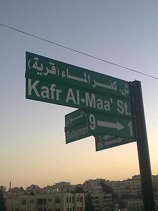
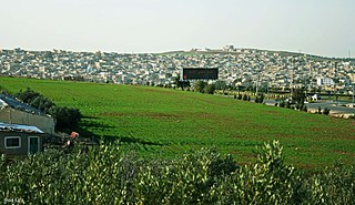
Kafr Al-Maa is one of the Al-Kourah District towns, in the province of Irbid, Jordan, and away from the Irbid city district center 28 km to the south-west, and the capital, Amman, about 81 km in the north-west direction. It had a population of 17,919 in 2015.

Samma is a village in northern Jordan, located 80 kilometers north of the capital Amman and about 18 km West of the city Irbid. It is perched on a hilltop 325 metres (1,066 ft) above sea level overlooking Jordan Valley and the Sea of Tiberias.

