Aragatsotn is a province (marz) of Armenia. It is located in the western part of the country. The capital and largest city of the province is the town of Ashtarak. The Statistical Committee of Armenia reported its population was 132,925 in the 2011 census.
Oshakan is a village in the Ashtarak Municipality of the Aragatsotn Province of Armenia located 8 kilometers southwest from Ashtarak. It is well known to historians and pilgrims of the Armenian Apostolic Church as the site of the grave of Mesrop Mashtots, the inventor of the Armenian alphabet.

Alapars is a village in the Kotayk Province of Armenia. The village has 860 dwellings, a school, house of culture, and library. The population is entirely Armenian.

Geghhovit is a village in the Martuni Municipality of the Gegharkunik Province of Armenia.

Lichk is a village in the Martuni Municipality of the Gegharkunik Province of Armenia, located to the south of Lake Sevan.

Zolakar, is a village in the Martuni Municipality of the Gegharkunik Province of Armenia.
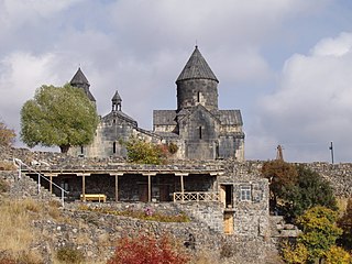
Tegher Monastery is an early 13th-century Armenian monastery and church located on the southeastern slopes of Mount Aragats near the modern village of Tegher, and across the gorge from the village of Byurakan in the Aragatsotn Province of Armenia. It was built for Princess Khatun, the wife of Prince Vache I Vachutian who had purchased the district of Aragatzotn from the Zakarian brothers. The architect Vardapet Aghbayrik designed Tegher and the monasteries of Saghmosavank and Hovhannavank during the 13th century. The monastery survived intact during a time when Mongol invasions plagued the lands.


Beniamin is a village in the Akhuryan Municipality of the Shirak Province of Armenia. The town was renamed in 1945 in honor of Beniamin Galstian, a World War II general and native of the town. According to Ghevont Alishan, the old name of the village is "Chlofkhan or Chalovkhan", and was founded in 1828-1830 in the territory of the historical city of Draskhanakert. The Statistical Committee of Armenia reported its population was 745 in 2010, up from 702 at the 2001 census.
Jrambar is a village in the Aparan Municipality of the Aragatsotn Province of Armenia. The local economy is based on the nearby Aparan dam and reservoir, which supplies the capital Yerevan with drinking water. Prior to the construction of the dam, the cultural monuments of the historic village of Zovuni were moved stone-by-stone to higher ground to the east of the reservoir. The Zovuni cemetery sits to the east of the church, across a ravine.
Karbi is a village in the Ashtarak Municipality of the Aragatsotn Province of Armenia, near the town of Ashtarak. Within the area there is a triple-nave basilica of S. Astvatsatsin dated to 1691-93 with an unattached adjacent belfry of 1338. In the village there are also S. Gevorg or S. Kiraki church of the 11th to 13th centuries, Tsiranavor, a Tukh Manuk shrine, and "Zargarents Zham" chapel built between the 11th and 13th centuries.

Mastara is a village in the Talin Municipality of the Aragatsotn Province of Armenia. The 5th-century Armenian Church of S. Hovhannes is situated in the northeastern half of the village, while the church of S. Stepanos Nakhava sits on a hilltop to the north. There is also the small medieval Tukh Manuk Church in the village to the southeast.

Yeranos is a village in the Martuni Municipality of the Gegharkunik Province of Armenia.

Zovaber is a village in the Sevan Municipality of the Gegharkunik Province of Armenia.
The Tukh Manuk Shrine of Oshakan is located in the town of Oshakan in Aragatsotn Marz, Armenia. Tukh Manuk literally translates to "dark baby" or "dark-skinned youth."

Mashtots Hayrapet is a church located within the village of Garni in the Kotayk Province of Armenia. It was built in the 12th century at the site of what was a pagan shrine. A stone carved from red tufa is situated at the right of the entrance upon a low rock wall. It has on it the design of a bird perched on a floral stem with the rosette of eternity under its tail. The rosette is also a distinctive pagan symbol representing the sun or the moon, symbolizing the eternal cycle of life, death, and rebirth. It is said that because of this pagan symbology, this stone has a connection to the prior shrine.

The Surb Astvatsatsin Church ; also Yeghipatrush Church is a church located in the village of Yeghipatrush in the Aragatsotn Province of Armenia. It was constructed between the 10th and 13th centuries.

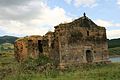
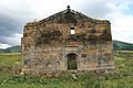
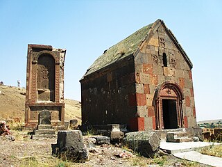
Saint Christopher Monastery, is a restored Armenian church of the 7th century, located in a cemetery 2.2 kilometres (1.4 mi) southeast of the outskirts of Dashtadem village and Dashtadem Fortress in the Aragatsotn Province of Armenia. Adjacent to the church (north) is a 13th-century stone rectangular tower (bell/defensive/funerary) with sloped walls. It has small windows on the upper portion of the wall, but no access to the interior. The surrounding cemetery has been in use from the 6th century to modern times, and contains several interesting khachkars. A low-stone wall surrounds the complex and a section of the old cemetery. Dashtadem Fortress may be seen in the distance from the monastery.
Tukh Manuk refers to archaic rural shrines in Armenia. Their origin is regarded to be pre-Christian or pagan, but are now a part of a folk tradition existing within the Armenian Church. Many are situated in church ruins or in crudely-built enclosures, others are well constructed stone chapels. Some of them are thought to date back to the 5th century, or even the BCE era.