
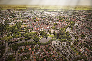
Ommen is a municipality and a Hanseatic city in the eastern Netherlands. It is located in the Vecht valley of the Salland region in Overijssel. Historical records first name Ommen in the early 12th century and it was officially founded as a city in 1248. The municipality had a population of 18,295 in 2021 and covers an area of 182.01 km2 (70.27 sq mi).

Breukelen is a town and former municipality in the Netherlands, in the province of Utrecht. It is situated to the northwest of Utrecht, along the river Vecht and close to the lakes of the Loosdrechtse Plassen, an area of natural and tourist interest. It is located in an area called the Vechtstreek. It is the namesake of the borough of Brooklyn in New York City, United States.

Loenen is a former municipality in the Netherlands, in the province of Utrecht. It was in the Vechtstreek area. On January 1, 2011, Loenen merged with Breukelen and Maarssen to form Stichtse Vecht.

Maarssen is a town in the middle of the Netherlands, in the province of Utrecht, along the river Vecht and the Amsterdam–Rhine Canal. The west of Maarssen is called Maarssen-Broek whereas the east is called Maarssen-Dorp. Both put together and joined by other small towns around provide the area of Maarssen.
Woerden is a city and a municipality in central Netherlands. Due to its central location between Amsterdam, Rotterdam, The Hague, and Utrecht, and the fact that it has rail and road connections to those cities, it is a popular town for commuters who work in those cities.
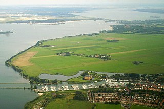
Muiden is a city and former municipality in the Netherlands, in the province of North Holland. It lies at the mouth of the Vecht and is in an area called the Vechtstreek. Since 2016, Muiden has been part of the new municipality of Gooise Meren.

Vreeland is a village in the Dutch province of Utrecht. It was a part of the former municipality of Loenen. Since 2011 it has been part of the new formed municipality of Stichtse Vecht. It is located on the river Vecht, about 2 km north of Loenen aan de Vecht. It received city rights in 1265. In 2015, the village celebrates the 650th year of its foundation.

Nigtevecht is a village in the province of Utrecht, Netherlands with a population of 1,395. Formerly part of the municipality of Loenen; it has been part of the newly-formed municipality of Stichtse Vecht since 2011. It is situated about 9 km (5.6 mi) west of Bussum along the Vecht River in the Vechtstreek.

Tuyll is the name of a noble Dutch family, with familial and historical links to England, whose full name is Van Tuyll van Serooskerken. Several knights, members of various courts, literary figures, generals, ambassadors, statesmen and explorers carried the family name.

Loenersloot is a village in the Dutch province of Utrecht. It was a part of the former municipality of Loenen. Since 2011 it has made part of the new formed municipality of Stichtse Vecht. It lies about 12 km west of Hilversum. It is located on the Angstel River.
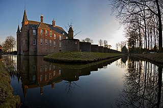
Oud-Zuilen is a village in the Dutch province of Utrecht. It is a part of the municipality of Stichtse Vecht, and lies about 4 km northwest of Utrecht. It is in an area called the "Vechtstreek". Zuylen Castle is located in the village.

Tienhoven is a village in the Dutch province of Utrecht. It is a part of the municipality of Stichtse Vecht, and lies about 7 km north of Utrecht.

Nieuwer-Ter-Aa is a village in the Dutch province of Utrecht (province). It is a part of the municipality of Stichtse Vecht, and lies about 13 km northwest of Utrecht.

Tienhoven is a village in the Dutch province of Utrecht. It is a part of the municipality of Vijfheerenlanden, and lies about 10 km southwest of IJsselstein.

Maarsseveen is a former hamlet in the Dutch province of Utrecht. It was located on the east bank of the Vecht River, opposite the village of Maarssen, and has now been completely absorbed by that town. It makes part of the municipality of Stichtse Vecht.

Portengen is a hamlet in the Dutch province of Utrecht. It is located in the municipality of Stichtse Vecht, 1 km (0.62 mi) northeast of Kockengen.

Breukeleveen is a hamlet in the Dutch province of North Holland. It is in the municipality of Wijdemeren, and lies southwest of Loosdrecht.
Zuylen Castle is a Dutch castle at the village of Oud-Zuilen just north of the city of Utrecht. It is located along the river Vecht at the southern end of the Vechtstreek.

Stichtse Vecht is a municipality of the Netherlands and lies in the northwestern part of the province of Utrecht.

DHSC is a football club in the Ondiep district of Utrecht, Netherlands. The club plays in the 2022-23 Vierde Divisie.


