Zulueta (Remedios)

Last updated
Zulueta
Village
"La Cuna del Futbol" en Zulueta.jpg
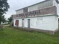
Building at the Camilo Cienfuegos Stadium
Escudo de Zulueta.jpg
Nickname: 
La Cuna del Fútbol [1]
Villa Clara Map - Zulueta (Remedios).png
Map of Zulueta Popular Council (Red) in Remedios (Orange) in Villa Clara (Yellow)
Cuba (location map).svg
Red pog.svg
Location of Zulueta in Cuba
Villa Clara Province location map.png
Red pog.svg
Zulueta (Remedios) (Villa Clara Province)
Remedios location map.png
Red pog.svg
Zulueta (Remedios) (Remedios)
Coordinates: 22°22′4.51″N79°34′8.47″W / 22.3679194°N 79.5690194°W / 22.3679194; -79.5690194
Country Cuba
Province Villa Clara
Municipality Remedios
Founded1869
Area
  Total4.579 km2 (1.768 sq mi)
Elevation
180 m (590 ft)
Population
 (2012) [2]
  Total5,709
Time zone UTC-5 (EST)
Area code +53-4239

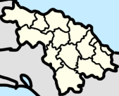
Zulueta is a Cuban village and consejo popular ("popular council", i.e. hamlet) of the municipality of Remedios, in Villa Clara Province. It is considered the Cuban birthplace of football [3] and, with a population of ca. 10,000 [4] is the most populated village in the municipality after Remedios.

Contents

History

The village was founded in 1869 and in 1876 was connected to the railway network. Until the administrative reform of 1977, it was an autonomous municipality of 117 km², that included the villages of Floridanos and Guadalupe, [5] which are both currently part of Camajuaní.

In the 1907 census Zulueta, which was a barrio at the time was switched from being a part of the municipality of Camajuaní to Remedios. [6]

Geography

Zulueta is located on a valley between Remedios (15 km north) and Placetas (13 km south), and is crossed in the middle by a road named "Carretera a Zulueta". It is 22 km far from Camajuaní, 23 from Caibarién, the nearest seaside town, 42 from Cabaiguán, 48 from Santa Clara, and 61 from Sancti Spíritus.

The railway station is located 3.8 km south, in a small settlement named Tahón ( 22°20′29″N79°34′43″W / 22.3415°N 79.5787°W / 22.3415; -79.5787 ). It is part of the Santa Clara-Camajuaní-Morón-Nuevitas line, and has a minor branch to Placetas; part of the old line (1876) Caibarién-Placetas via Camajuaní.[ citation needed ]

Sports

Zulueta is considered the Cuban birthplace of football because it was one of the first villages in which this sport was brought by Spanish traders, in early 20th century. [3] A testimony of this relationship is, for example, the Monumento al Balón, a stone sculpture of a football ball (balón) located in town's centre, with the inscription Zulueta - Cuna del Fútbol (Zulueta - Birthplace of Football). [7] [8] Another example is the presence of a football ball in the coat of arms.[ citation needed ]

The football club Villa Clara, playing in Santa Clara at the Sandino Stadium, and representing the city and the whole province; is de jure based in Zulueta and plays some matches at the Camilo Cienfuegos Stadium. [9] It also exists a documentary, named Gol de Cuba , that speaks about Zulueta and its passion for the association football. [10]

Notable people

See also

Related Research Articles

<span class="mw-page-title-main">Placetas</span> Municipality in Villa Clara, Cuba

Placetas is a city in the Villa Clara Province in the center of Cuba; before the change in the country's government in 1959 the province was called Las Villas. The town is also known as La Villa de los Laureles because of its wild laurel trees. Placetas is also a municipio, one of 13 subdivisions of the Villa Clara Province. Cuba's geographical center, Guaracabulla, is located in this municipality.

<span class="mw-page-title-main">Villa Clara Province</span> Province of Cuba

Villa Clara is one of the provinces of Cuba. It is located in the central region of the island bordering on the Atlantic Ocean to the north, Matanzas Province to the west, Sancti Spiritus Province to the east, and Cienfuegos Province to the South. Villa Clara shares with Cienfuegos and Sancti Spiritus on the south the Escambray Mountain Range. Its main cities are Santa Clara, Remedios, Sagua La Grande, Camajuani, Caibarién, Ranchuelo, Placetas, and Manicaragua.

<span class="mw-page-title-main">Carretera Central (Cuba)</span> Highway in Cuba

The Carretera Central (CC), meaning "Central Road", is a west-east highway spanning the length of the island of Cuba.

<span class="mw-page-title-main">Santa Clara, Cuba</span> City in Villa Clara, Cuba

Santa Clara is the capital city of the Cuban province of Villa Clara. It is centrally located in the province and Cuba. Santa Clara is the fifth-most populous Cuban city, with a population of nearly 250,000.

<span class="mw-page-title-main">Caibarién</span> Municipality in Villa Clara, Cuba

Caibarién is a municipality city in the Villa Clara province of Cuba.

<span class="mw-page-title-main">Remedios, Cuba</span> Municipality in Villa Clara, Cuba

Remedios, also known as San Juan de los Remedios, is a city and municipality located 3 miles (4.8 km) from the northern coast of Cuba, in the center of the island. It is the oldest Spanish settlement in the former Las Villas province. It is now part of the province of Villa Clara.

<span class="mw-page-title-main">Villa Clara (football club)</span> Cuban football club

Villa Clara is a Cuban professional football club based in Santa Clara, Villa Clara Province, which currently play Cuban first division.

<span class="mw-page-title-main">Camajuaní</span> Municipality in Villa Clara, Cuba

Camajuaní is a municipality and town in the Villa Clara Province of Cuba.

<span class="mw-page-title-main">Parrandas</span>

Parrandas are traditional carnival-like street parties with origins date back to the 19th century. They take place in northern and central cities of the former Las Villas province in Cuba. Most famous parrandas are celebrated in Remedios colonial city where these festivities were originated. Second most popular are celebrated in Camajuaní, followed in popularity by Vueltas, Zulueta, Chambas, Guayos, El Santo, Taguayabón, Buenavista, Calabazar de Sagua, Zaza del Medio, Falcón, Vega Alta and many more small town of this central region of Cuba.

<span class="mw-page-title-main">San Antonio de las Vueltas</span> Village in Villa Clara, Cuba

San Antonio de las Vueltas, also known as Vueltas, is a village and consejo popular in central northern Cuba, belonging to the municipality of Camajuaní, Villa Clara Province. It is the most populated village in the municipality after Camajuaní.

<span class="mw-page-title-main">Santa Clara railway station (Cuba)</span> Railway station in Santa Clara, Cuba

Santa Clara is the main railway station of the city of Santa Clara, seat of Villa Clara Province, Cuba. It is owned by the state company Ferrocarriles de Cuba (FFCC) and is located in front of Parque de los Mártires. It is one of the most important stations of Cuba and, along with Havana Central, Santiago and Camagüey, is a network's divisional headquarters.

<span class="mw-page-title-main">Casilda (Trinidad)</span> Village in Sancti Spíritus, Cuba

Casilda is a Cuban village and consejo popular of the municipality of Trinidad, Sancti Spíritus Province.

<span class="mw-page-title-main">Esperanza (Ranchuelo)</span> Village in Villa Clara, Cuba

Esperanza, also known as La Esperanza, is a Cuban village and consejo popular of the municipality of Ranchuelo, in Villa Clara Province. It is the most populated municipal settlement after Ranchuelo.

<span class="mw-page-title-main">Mataguá</span> Village in Villa Clara, Cuba

Mataguá is a Cuban village and consejo popular of the municipality of Manicaragua, in Villa Clara Province. With a population of ca. 10,000, it is the most populated village in the municipality after Manicaragua.

<span class="mw-page-title-main">Roads in Cuba</span> Highway system in Cuba

The road network of Cuba consists of 60,858 km (37,815 mi) of roads, of which over 29,850 km (18,550 mi) are paved and 31,038 km (19,286 mi) are unpaved. The Caribbean country counts also 654 km (406 mi) of motorways (autopistas).

<span class="mw-page-title-main">Taguayabón</span> Village in Villa Clara, Cuba

Taguayabón is a Cuban village and consejo popular (ward) of the municipality of Camajuaní, in Villa Clara Province. In 2012 it had a population of 2053.

<span class="mw-page-title-main">Calabazar de Sagua</span> Village in Villa Clara, Cuba

Calabazar de Sagua, also shortened as Calabazar, is a Cuban village and consejo popular of the municipality of Encrucijada, in Villa Clara Province, Cuba. In 2011 it had a population of 7,912.

<span class="mw-page-title-main">Cascajal</span> Village in Villa Clara, Cuba

Cascajal is a Cuban village and consejo popular of the municipality of Santo Domingo, in Villa Clara Province. With a 2011 population of 7,251, it is the most populated municipal settlement after Santo Domingo.

<span class="mw-page-title-main">Báez</span> Village in Villa Clara, Cuba

Báez is a Cuban village and consejo popular of the municipality of Placetas, in Villa Clara Province. In 2011 it had a population of around 7,000.

<span class="mw-page-title-main">Crucero Carmita</span> Village in Villa Clara, Cuba

Crucero Carmita also known as El Crucero de Carmita is a village in Luis Arcos Bergnes Popular Council, Camajuaní, Villa Clara, Cuba. It had a population of 704 people and has 261 houses. Nearby towns are Fusté, San José, Dolores, Corona, Aguijón, and Santana.

References

  1. i.e.: The Birthplace of Football
  2. "Zulueta (Remedios, Provinz Villa Clara, Kuba) - Einwohnerzahlen, Grafiken, Karte, Lage, Wetter und Web-Informationen".
  3. 1 2 "Gol de Cuba" article
  4. Source: Mapa de Carreteras de Cuba (Road map of Cuba). Ediciones GEO, Havana 2011 - ISBN   959-7049-21-X
  5. (in Spanish) History of Zulueta at guije.com
  6. Population. Cuba: census.gov. 1907. p. 6.
  7. (in Spanish) "The Island of Football" ( La Vanguardia )
  8. Monumento al Balón on Panoramio
  9. "Estadio Camilo Cienfuegos", Zulueta (soccerway)
  10. Gol de Cuba