The Šiška District, or simply Šiška, is the most populous district of the City Municipality of Ljubljana, the capital of Slovenia. It is named after the former villages of Spodnja Šiška and Zgornja Šiška.

The Bežigrad District, or simply Bežigrad, is a district of the City Municipality of Ljubljana. It encompasses the northern part of Ljubljana, the capital of Slovenia, between the southern rail line to the south, the Upper Carniola rail line to the west, the highway loop to the north, and Šmartno Street and the Žale Cemetery to the east. It extends on both sides of Vienna Street, which is its central axis and main traffic artery. In the narrow sense, it includes the neighborhoods of Bežigrad, Brinje, Nove Stožice, and Sava Development. In the broader sense, Bežigrad is sometimes considered to include the northern Ljubljana suburbs of Stožice, Ježica, and the Črnuče District.
The Vič District, or simply Vič, is a district of the City Municipality of Ljubljana. It encompasses the western part of Ljubljana, the capital of Slovenia. It is named after the former village of Vič.

The Moste District, or simply Moste, is a district of the City Municipality of Ljubljana. It encompasses the east-central part of Ljubljana, the capital of Slovenia. It is named after the former village of Moste.
The Črnuče District, or simply Črnuče, is a district of the City Municipality of Ljubljana in the northern part of Ljubljana, the capital of Slovenia. It is named after the former town of Črnuče.

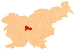
The Center District, or simply the Center, is a district of the City Municipality of Ljubljana in the center of Ljubljana, the capital of Slovenia. It has an area of about 5 square kilometres (1.9 sq mi).
The Dravlje District, or simply Dravlje, is a district of the City Municipality of Ljubljana, the capital of Slovenia. It is named after the former village of Dravlje.
The Golovec District, or simply Golovec, is a district of the City Municipality of Ljubljana, the capital of Slovenia. It encompasses Golovec Hill, which dates back to the Carboniferous period and consists of clastic rock.

The Jarše District, or simply Jarše, is a district of the City Municipality of Ljubljana, the capital of Slovenia. It is named after the former village of Jarše, now part of the Bežigrad District.
The Polje District, or simply Polje, is a district of the City Municipality of Ljubljana, the capital of Slovenia. It is named after the former village of Polje.
The Posavje District, or simply Posavje, is a district of the City Municipality of Ljubljana, the capital of Slovenia.
The Rožnik District, or simply Rožnik, is a district of the City Municipality of Ljubljana, the capital of Slovenia. It is named after Rožnik Hill.
The Rudnik District, or simply Rudnik, is a district of the City Municipality of Ljubljana, the capital of Slovenia. It is named after the former village of Rudnik.
The Sostro District, or simply Sostro, is a district of the City Municipality of Ljubljana, the capital of Slovenia. It is named after the former village of Sostro.
The Šentvid District, or simply Šentvid, is a district of the City Municipality of Ljubljana, the capital of Slovenia. It is named after the former village of Šentvid.

The Trnovo District, or simply Trnovo, is a district of the City Municipality of Ljubljana, the capital of Slovenia.

Tacen is a formerly independent settlement in the northwest part of the capital Ljubljana in central Slovenia. It was part of the traditional region of Upper Carniola and is now included with the rest of the municipality in the Central Slovenia Statistical Region. It includes the hamlets of Na Grškem, Sige, V Bregu, and Šmarna Gora.

Sostro is a formerly independent settlement in the eastern part of the capital Ljubljana in central Slovenia. It was part of the traditional region of Lower Carniola and is now included with the rest of the municipality in the Central Slovenia Statistical Region. In addition to the main settlement, Sostro includes the hamlet of Betežica, located to the northeast along Betežčica Creek, and the hamlet of Glastavci in the wooded hills above Betežica. Sostro is also the source of the name of the Sostro District, the largest district of the capital.

Mount Saint Mary, originally known as Holm, is an inselberg in the north of Ljubljana, the capital of Slovenia. The mountain is part of the city's Šmarna Gora District. It is the highest hill in the city and a popular hiking destination.