
The M62 is a 107-mile-long (172 km) west–east trans-Pennine motorway in Northern England, connecting Liverpool and Hull via Manchester, Bradford, Leeds and Wakefield; 7 miles (11 km) of the route is shared with the M60 orbital motorway around Manchester. The road is part of the unsigned Euroroutes E20 and E22.

The A62 road in Northern England runs between the cities of Leeds in West Yorkshire and Manchester in Greater Manchester covering a distance of 38.5 miles (62.0 km). It passes through Heckmondwike, Huddersfield, Failsworth and Oldham.

The A58 is a major road in Northern England running between Prescot, Merseyside and Wetherby, West Yorkshire.

Failsworth is a town in the Metropolitan Borough of Oldham in Greater Manchester, England, 4 miles (6.4 km) north-east of Manchester and 3 miles (4.8 km) south-west of Oldham. The orbital M60 motorway skirts it to the east. The population at the 2011 census was 20,680. Historically in Lancashire, Failsworth until the 19th century was a farming township linked ecclesiastically with Manchester. Inhabitants supplemented their farming income with domestic hand-loom weaving. The humid climate and abundant labour and coal led to weaving of textiles as a Lancashire Mill Town with redbrick cotton mills. A current landmark is the Failsworth Pole. Daisy Nook is a country park on the southern edge.

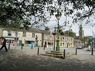
Milnrow is a town within the Metropolitan Borough of Rochdale, in Greater Manchester, England. It lies on the River Beal at the foothills of the South Pennines, and forms a continuous urban area with Rochdale. It is 2 miles (3.2 km) east of Rochdale town centre, 10 miles (16.1 km) north-northeast of Manchester, and spans from Windy Hill in the east to the Rochdale Canal in the west. Milnrow is adjacent to junction 21 of the M62 motorway, and includes the village of Newhey, and hamlets at Tunshill and Ogden.
Littleborough is a town in the Metropolitan Borough of Rochdale, Greater Manchester, England, in the upper Roch Valley by the foothills of the South Pennines, 3 miles (4.8 km) northeast of Rochdale and 13 miles (20.9 km) northeast of Manchester; Milnrow and the M62 motorway are to the south, and the rural uplands of Blackstone Edge to the east. According to the 2001 census, Littleborough, and its suburbs of Calderbrook, Shore and Smithy Bridge, had a population of 13,807.

The A635 is a main road that runs between Manchester and Doncaster running east–west through Stalybridge, Saddleworth Moor, Holmfirth, Barnsley and the Dearne Valley. The section forming the eastern part of the Mancunian Way is a motorway and is officially designated as the A635(M) though there is no road sign with this designation, and the signs at the entrance of Mancunian Way westbound show A57(M).

Outlane is a village in Kirklees, West Yorkshire, England, situated approximately 2.5 miles (4 km) south-west of Elland, 3.7 miles (6 km) north-west of Huddersfield and 4.5 miles (7 km) south of Halifax.

Marsh is a suburb of Huddersfield, West Yorkshire, England that is situated 0.93 miles (1.5 km) west of the town centre.

Newhey is a village near the town of Milnrow in the Metropolitan Borough of Rochdale, in Greater Manchester, England. It lies at the foot of the South Pennines, by Junction 21 of the M62 motorway and on the River Beal, 3 miles (4.8 km) east-southeast of Rochdale, 10 miles (16.1 km) northeast of Manchester.

The A5103 is a major road in England. It runs from Piccadilly Gardens in Manchester city centre to junction 3 of the M56 motorway and is one of Manchester's principal radial routes.

The A671 is a road in the North West of England, that runs between Oldham, Greater Manchester and Worston, near Clitheroe, Lancashire. Major towns on the route include Rochdale and Burnley. The road is approximately 35 miles (56 km) long. Between Burnley and the A59, the A671 has primary status.

Oakes is a district of Huddersfield, West Yorkshire, England. It is situated 2 miles (3 km) to the west of the town centre off the A640 New Hey Road towards the M62 motorway, between Marsh, Lindley, Quarmby and Salendine Nook.

The A643 is a main road between Leeds and Huddersfield in West Yorkshire, England. Its eastern end is at the Armley Gyratory roundabout on the western edge of Leeds City Centre. The road then goes through:

The A642 is an A-road in West Yorkshire, England which runs from Huddersfield to the A64 near Leeds. It partly follows the route of a historic turnpike road, which is evidenced by surviving toll houses.

The South Pennines is a region of moorland and hill country in northern England lying towards the southern end of the Pennines. In the west it includes the Rossendale Valley and the West Pennine Moors. It is bounded by the Greater Manchester conurbation in the west and the Bowland Fells and Yorkshire Dales to the north. To the east it is fringed by the towns of West Yorkshire whilst to the south it is bounded by the Peak District. The rural South Pennine Moors constitutes both a Site of Special Scientific Interest and Special Area of Conservation.

Stanney Brook is a watercourse in Greater Manchester, England. It originates in the Burnedge area of Shaw and Crompton, and flows through Milnrow into Rochdale before joining the River Roch at Newbold Brow. Alone among the watercourses of Milnrow and Newhey, it does not pass through the centre of either village, and flows directly into the River Roch, rather than first into the River Beal. Its name derives from the Lancashire dialect word "stanner", a ridge of stones. It is also unusual in that the borough in which it rises, changes, depending on the wetness of surrounding moorland. The brook drops 100 metres in a little over 5.5 kilometres, or 330feet in 3.5 miles. It is culverted four times, generally is only 60 cm (2 ft) wide, and rarely exceeds 90 cm (3 ft) in width at any point.

Denshaw is a village in the civil parish of Saddleworth in the Metropolitan Borough of Oldham, in Greater Manchester, England. It lies by the source of the River Tame, high amongst the Pennines above the village of Delph, 4.6 miles (7.4 km) northeast of Oldham,3.3 miles (5.3 km) north-northwest of Uppermill and Shaw and Crompton. It has a population of around 500.

Greater Manchester Bus route 58 was operated by First Greater Manchester between Rochdale and Middleton bus stations via Milnrow, Newhey, Shaw & Crompton, Oldham and Chadderton. It had a sister route 59 which operated on the same route between Middleton and Shaw, and also served Rushcroft. The route was curtailed to run between Rochdale and Oldham in 2017 and was withdrawn in 2020 during the Coronavirus pandemic. The route is now covered by services 57 and 182.
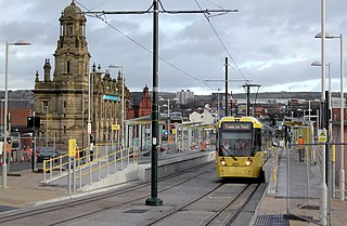
The Oldham and Rochdale Line (ORL) is a tram line of the Manchester Metrolink in Greater Manchester running from Manchester city centre to Rochdale town centre via Oldham, using most of the trackbed of the former Oldham Loop Line which closed in 2009. The line was re-opened in a modified form as a tramway between 2012 and 2014, as part of phase three of the system's expansion.
