A617 road

Last updated

UK road A617.svg
A617
Route information
Length34 mi (55 km)
Major junctions
From Newark-on-Trent
Major intersectionsA46
UK road A616.svg A616
UK road A612.svg A612
UK road A614.svg A614
UK road A6191.svg A6191
UK road A6117.svg A6117
UK road A60.svg A60
UK road A38.svg A38
UK road A6075.svg A6075
UK-Motorway-M1.svg M1
UK road A6175.svg A6175
UK road A61.svg A61
To Chesterfield
Location
Country United Kingdom
Road network

The A617 road runs through the northern East Midlands, England, between Newark-on-Trent and Chesterfield.

Contents

Route

The route runs south-east to north-west through the northern East Midlands, largely through former coal-mining areas. It runs largely parallel to the A616 road, around six miles further south.

Newark to Sutton-in-Ashfield

Hockerton parish church Church of St. Nicholas, Hockerton - geograph.org.uk - 53816.jpg
Hockerton parish church

The eastern terminus begins on the A46 Newark bypass, at the roundabout with the A616, on the former route of the Great North Road in the Newark and Sherwood district of Nottinghamshire, as a trunk road. It traverses the Trent Valley, crossing the River Trent at narrow bridge only really passable by light traffic; Kelham Bridge was built in 1857 when larger road vehicles never existed, and is mildly dangerous. The eastern terminus of the route was formerly in Kelham, where it met the former route of the A616 at a T-junction. It meets the Trent Valley Way, which it follows to Averham. A mile to the south is Staythorpe Power Station, with a traffic lights exit to the south, and the route is crossed by electricity lines. Before Micklebarrow Hill, the A612 leaves to the west at traffic lights for Southwell. It passes through Hockerton and the Spread Eagle, following a northern ridge of the River Greet, further to the south. There is a long straight towards Kirklington, passing Maxeys Farm Shop. [1]

It passes through Kirklington, known for its former Kirklington Hall Research Station, now a residential special school, and the road is crossed by the Robin Hood Way. There is an exit to the north for Eakring, and its National Grid Training Centre. It passes to the south of Bilsthorpe, with an exit to the south to Hexgreave Park [2] (in Farnsfield). Close to a line of pylons, it crosses the former north-south Southwell-Mansfield railway line, and further on officially enters Sherwood Forest, before an exit to the south for Farnsfield. To the north is Lockwell Hill Activity Centre. [3] Entering the parish of Rainworth, it meets the busy north–south A614 at the busy Lockwell Hill Roundabout and approaches Rainworth on Centenary Avenue. Rainworth is now bypassed, and the former route is the B6020. The eastern end of the bypass crosses a former railway, and meets the B6020 at a roundabout, where the dual carriageway begins, close to the JET Python Hill Service Station on the B6020. The main characteristic of this dual-carriageway, heavily landscaped bypass is that it was obviously built in anticipation of a similar (dual-carriageway) bypass of Mansfield, which although planned, never arose, and was built as single carriageway instead. There is an exit to the north with traffic lights for a coal disposal point.

The Rainworth bypass crosses Clipstone Forest and Rainworth Water, enters Mansfield District, and meets the former route of the A617 at the large landscaped Three Thorn Roundabout (named after Three Thorn Hollow Farm), built in anticipation of a bridge over the roundabout at the junction. The £8m Rainworth Bypass, built by Birse, was opened on Friday 23 June 2000 at 1.30pm with a commemorative plaque unveiled on the trussed footbridge to Strawberry Hill. [4] To the north of the roundabout is Ransom Wood Business Park. [5] A large wind farm is to the south, and the bypass meets the A6117 at a roundabout, and the A60 at an at-grade junction, where it enters the district of Ashfield, another former coal mining district. It passes under the A611 and meets the A38 Sutton-in-Ashfield bypass. The Mansfield Bypass (MARR) has no grade-separated junctions. The southern section from Rainworth to the A38 opened on 21 December 2004 and was built by Alfred McAlpine, and designed by Babtie, Shaw and Morton of Glasgow.

The Sherwood Way Mansfield Bypass in September 2005; the 6-mile PS31m Mansfield and Ashfield Regeneration Route opened in December 2004 Mansfield By-pass - geograph.org.uk - 57496.jpg
The Sherwood Way Mansfield Bypass in September 2005; the 6-mile £31m Mansfield and Ashfield Regeneration Route opened in December 2004

Sutton-in-Ashfield to Chesterfield

The road briefly follows the A38 trunk road towards Mansfield. The King's Mill Hospital is directly to the east, and the road follows a route first built as the A6075, and is a non-trunk road. This is the western section of the Mansfield Bypass. Entering Mansfield district, the route of the Mansfield bypass follows a new route of the A617 to Radmanthwaite, where it meets the former route, now the dual-carriageway A6191.

Pleasley Bypass in December 2014; there have been plans for a Pleasley Bypass extension and a Glapwell Bypass Footbridge over Chesterfield Road, Pleasley - geograph.org.uk - 1241953.jpg
Pleasley Bypass in December 2014; there have been plans for a Pleasley Bypass extension and a Glapwell Bypass

It passes through Pleasleyhill, becoming dual-carriageway where it crosses the River Meden entering Derbyshire and Bolsover District, meeting the B6407 and B6417 at the large Pleasley Roundabout with access for the Sports Direct warehouse at Shirebrook via the B6407; the Pleasley Bypass was built in the early 1970s. The JET Staleys garage at the eastern end of Glapwell closed in 2011. It passes through Glapwell, passing the Crown Carveries Young Vanish, [6] and the Plug and Feathers [7] At Bramley Vale there is Eve Trakway and the Bramley Vale Fish Bar. This is the site of the former Glapwell Colliery. At Doe Lea in Ault Hucknall, the road deviates to a dual-carriageway section to the north, built in anticipation of the M1, entering North East Derbyshire.

The road meets the M1 motorway and A6175 at the busy Heath Interchange in Heath and Holmewood. 13.5 miles of the M1 were opened on Wednesday 25 October 1967, when the section from Pinxton (junction 28) to Barlborough (junction 30) opened, including junction 29, built by John Laing Construction. Construction began in July 1965. [8] To improve access to Chesterfield from the M1 to the south, a new section of dual carriageway was built. On the east-bound carriageway is the Esso Heath Service Station [9] with a Subway. The former route takes part of the B6039 through the parish of Grassmoor, Hasland and Winsick and Hasland in Chesterfield district; the A617 Hasland Bypass opened on 15 September 1978. There is a grade-separated junction with the B6425. The road enters the borough of Chesterfield, and the western terminus is with the A61 at the Lordsmill Roundabout, having crossed under the Midland Main Line.

Related Research Articles

<span class="mw-page-title-main">A41 road</span> Road in England

The A41 is a trunk road between London and Birkenhead, England. Now in parts replaced by motorways, it passes through or near Watford, Kings Langley, Hemel Hempstead, Aylesbury, Bicester, Solihull, Birmingham, West Bromwich, Wolverhampton, Newport, Whitchurch, Chester and Ellesmere Port.

<span class="mw-page-title-main">A6 road (England)</span> North-south road in England

The A6 is one of the main north–south roads in England. It runs from Luton in Bedfordshire to Carlisle in Cumbria, although it formerly started at a junction with the A1 at Barnet. It is the fourth longest numbered road in Britain; only the A1, A38 and A30 are longer.

<span class="mw-page-title-main">A38 road</span> Trunk road in England

The A38, parts of which are known as Devon Expressway, Bristol Road and Gloucester Road, is a major A-class trunk road in England.

<span class="mw-page-title-main">A57 road</span> Road in England

The A57 is a major road in England. It runs east from Liverpool to Lincoln via Warrington, Cadishead, Irlam, Patricroft, Eccles, Salford and Manchester, then through the Pennines over the Snake Pass (between the high moorlands of Bleaklow and Kinder Scout), around the Ladybower Reservoir, through Sheffield and past Worksop. Between Liverpool and Glossop, the road has largely been superseded by the M62, M602 and M67 motorways. Within Manchester a short stretch becomes the Mancunian Way, designated A57(M).

<span class="mw-page-title-main">A61 road</span> Road in England

The A61 is a major trunk road in England connecting Derby and Thirsk in North Yorkshire by way of Alfreton, Clay Cross, Chesterfield, Sheffield, Barnsley, Wakefield, Leeds, Harrogate and Ripon. The road is closely paralleled by the M1 motorway between Derby and Leeds.

<span class="mw-page-title-main">A47 road</span> Road in England

The A47 is a major road in England linking Birmingham to Lowestoft, Suffolk. Most of the section between Birmingham and Nuneaton is now classified as the B4114. From Peterborough eastwards, it is a trunk road.

<span class="mw-page-title-main">A46 road</span> Road in England

The A46 is a major A road in England. It starts east of Bath, Somerset and ends in Cleethorpes, Lincolnshire, but it does not form a continuous route. Large portions of the old road have been lost, bypassed, or replaced by motorway development. Between Leicester and Lincoln the road follows the course of the Roman Fosse Way, but between Bath and Leicester, two cities also linked by the Fosse Way, it follows a more westerly course.

<span class="mw-page-title-main">A45 road</span> Major road in England

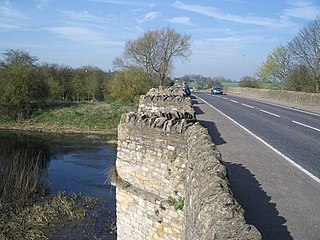
The A45 is a major road in England. It runs east from Birmingham past the National Exhibition Centre and the M42, then bypasses Coventry and Rugby, where it briefly merges with the M45 until it continues to Daventry. It then heads to Northampton and Wellingborough before running north of Rushden and Higham Ferrers and terminating at its junction with the A14 in Thrapston.

<span class="mw-page-title-main">A52 road</span> Major road in the East Midlands of England

The A52 is a major road in the East Midlands, England. It runs east from a junction with the A53 at Newcastle-under-Lyme near Stoke-on-Trent via Ashbourne, Derby, Stapleford, Nottingham, West Bridgford, Bingham, Grantham, Boston and Skegness to the east Lincolnshire coast at Mablethorpe. It is approximately 147 miles (237 km) long.

<span class="mw-page-title-main">A64 road</span> Road in West and North Yorkshire, England

The A64 is a major road in North and West Yorkshire, England, which links Leeds, York and Scarborough. The A64 starts as the A64(M) ring road motorway in Leeds, then towards York it becomes a high-quality dual carriageway until it is east of the city, where it becomes a single carriageway for most of its route to Scarborough.

<span class="mw-page-title-main">A428 road</span> Road in England

The A428 road is a major road in central and eastern England. It runs between the cities of Coventry and Cambridge by way of the county towns of Northampton and Bedford. Together with the A421,, the eastern section of the A428 forms the route between Cambridge and Oxford. The A428 was formerly part of the main route from Birmingham to Felixstowe before the A14 was fully opened in 1993.

<span class="mw-page-title-main">A453 road</span> Road in the Midlands

The A453 road was formerly the main trunk road connecting the English cities of Nottingham and Birmingham. However, the middle section of this mainly single-carriageway road has largely been downgraded to B roads or unclassified roads following the construction of the parallel M42-A42 link around 1990. The M42 was originally meant to pass further north than it does, and to join the M1 at Sandiacre in Derbyshire. The M42/A42 does not enter Derbyshire, but instead joins the M1 closer to the A453 junction at Kegworth. The A42 shadows the former A453 from Appleby Magna to Castle Donington. The road historically connected the East Midlands with the West Midlands.
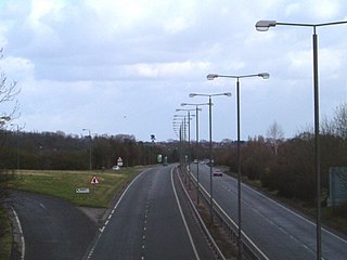
<span class="mw-page-title-main">A505 road</span> Road in southern England

The A505 is a road in the East of England. It follows part of the route of the Icknield Way and the corresponding Icknield Way Path and runs from Leighton Buzzard in Bedfordshire to the A11 Abington Interchange North in Cambridgeshire.

<span class="mw-page-title-main">Rainworth</span> Village in Nottinghamshire, England

Rainworth is a village in the ceremonial county of Nottinghamshire in the East Midlands of England. It is split between the local government districts of Newark and Sherwood and Mansfield.

<span class="mw-page-title-main">A516 road</span> Road in Derbyshire

The A516 road is a road in Derbyshire that runs from the A50 Junction 5, to the A601 in Derby. The road is used mostly for traffic flowing from the A50 to the A38.

<span class="mw-page-title-main">A616 road</span> Road in England

The A616 is a road that links Newark-on-Trent, Nottinghamshire, to the M1 motorway at Junction 30, then reappears at Junction 35A and goes on to Huddersfield, West Yorkshire.

<span class="mw-page-title-main">A6195 road</span> Road in South Yorkshire, England

The A6195 road runs through the Dearne Valley in South Yorkshire, England.

<span class="mw-page-title-main">A610 road</span> Road in England

The A610 is an A-road in England, which runs from Nottingham to Ambergate, where it joins the A6.

<span class="mw-page-title-main">A631 road</span> Road in England

The A631 is a road running from Sheffield, South Yorkshire to Louth, Lincolnshire in England. It passes through the counties of South Yorkshire, Nottinghamshire and Lincolnshire. The road has many towns on its route including Rotherham, Maltby, Gainsborough and Market Rasen. It is mostly single road throughout its length but has some stretches of dual carriageway as well.

<span class="mw-page-title-main">Horns Bridge</span> Bridge in Chesterfield, Derbyshire

Horns Bridge is a small area on the southeastern edge of Chesterfield, Derbyshire, England which was remarkable at one time for its congested intersection of roads, rivers, footpaths and railways.

References

Map all coordinates using: OpenStreetMap