
A glacier is a persistent body of dense ice that is constantly moving downhill under its own weight. A glacier forms where the accumulation of snow exceeds its ablation over many years, often centuries. It acquires distinguishing features, such as crevasses and seracs, as it slowly flows and deforms under stresses induced by its weight. As it moves, it abrades rock and debris from its substrate to create landforms such as cirques, moraines, or fjords. Although a glacier may flow into a body of water, it forms only on land and is distinct from the much thinner sea ice and lake ice that form on the surface of bodies of water.

The Alpine region of Switzerland, conventionally referred to as the Swiss Alps, represents a major natural feature of the country and is, along with the Swiss Plateau and the Swiss portion of the Jura Mountains, one of its three main physiographic regions. The Swiss Alps extend over both the Western Alps and the Eastern Alps, encompassing an area sometimes called Central Alps. While the northern ranges from the Bernese Alps to the Appenzell Alps are entirely in Switzerland, the southern ranges from the Mont Blanc massif to the Bernina massif are shared with other countries such as France, Italy, Austria and Liechtenstein.

An esker, eskar, eschar, or os, sometimes called an asar, osar, or serpent kame, is a long, winding ridge of stratified sand and gravel, examples of which occur in glaciated and formerly glaciated regions of Europe and North America. Eskers are frequently several kilometres long and, because of their uniform shape, look like railway embankments.

Glaciology is the scientific study of glaciers, or, more generally, ice and natural phenomena that involve ice.

The climatic snow line is the boundary between a snow-covered and snow-free surface. The actual snow line may adjust seasonally, and be either significantly higher in elevation, or lower. The permanent snow line is the level above which snow will lie all year.

Glacial motion is the motion of glaciers, which can be likened to rivers of ice. It has played an important role in sculpting many landscapes. Most lakes in the world occupy basins scoured out by glaciers. Glacial motion can be fast or slow, but is typically around 25 centimetres per day (9.8 in/d).

Glacial landforms are landforms created by the action of glaciers. Most of today's glacial landforms were created by the movement of large ice sheets during the Quaternary glaciations. Some areas, like Fennoscandia and the southern Andes, have extensive occurrences of glacial landforms; other areas, such as the Sahara, display rare and very old fossil glacial landforms.

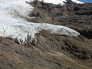
A terminal moraine, also called an end moraine, is a type of moraine that forms at the terminal (edge) of a glacier, marking its maximum advance. At this point, debris that has accumulated by plucking and abrasion, has been pushed by the front edge of the ice, is driven no further and instead is deposited in an unsorted pile of sediment. Because the glacier acts very much like a conveyor belt, the longer it stays in one place, the greater the amount of material that will be deposited. The moraine is left as the marking point of the terminal extent of the ice.

Crucial to the survival of a glacier is its mass balance of which surface mass balance (SMB), the difference between accumulation and ablation. Climate change may cause variations in both temperature and snowfall, causing changes in the surface mass balance. Changes in mass balance control a glacier's long-term behavior and are the most sensitive climate indicators on a glacier. From 1980 to 2012 the mean cumulative mass loss of glaciers reporting mass balance to the World Glacier Monitoring Service is −16 m. This includes 23 consecutive years of negative mass balances.

Glacier ice accumulation occurs through accumulation of snow and other frozen precipitation, as well as through other means including rime ice, avalanching from hanging glaciers on cliffs and mountainsides above, and re-freezing of glacier meltwater as superimposed ice. Accumulation is one element in the glacier mass balance formula, with ablation counteracting. With successive years in which accumulation exceeds ablation, then a glacier will experience positive mass balance, and its terminus will advance.

The retreat of glaciers since 1850 is a well-documented effect of climate change. The retreat of mountain glaciers provide evidence for the rise in global temperatures since the late 19th century. Examples include mountain glaciers in western North America, Asia, the Alps in central Europe, and tropical and subtropical regions of South America and Africa. Since glacial mass is affected by long-term climatic changes, e.g. precipitation, mean temperature, and cloud cover, glacial mass changes are one of the most sensitive indicators of climate change. The retreat of glaciers is also a major reason for sea level rise. Excluding peripheral glaciers of ice sheets, the total cumulated global glacial losses over the 26 years from 1993 to 2018 were likely 5500 gigatons, or 210 gigatons per year.

On a glacier, the accumulation zone is the area above the firn line, where snowfall accumulates and exceeds the losses from ablation,. The annual equilibrium line separates the accumulation and ablation zone annually. The accumulation zone is also defined as the part of a glacier's surface, usually at higher elevations, on which there is net accumulation of snow, which subsequently turns into firn and then glacier ice. Part of the glacier where snow builds up and turns to ice moves outward from there.
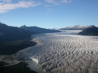
A glacier terminus, toe, or snout, is the end of a glacier at any given point in time. Although glaciers seem motionless to the observer, in reality they are in endless motion and the glacier terminus is always either advancing or retreating. The location of the terminus is often directly related to glacier mass balance, which is based on the amount of snowfall which occurs in the accumulation zone of a glacier, as compared to the amount that is melted in the ablation zone. The position of a glacier terminus is also impacted by localized or regional temperature change over time.
Fluvioglacial landforms or glaciofluvial landforms are those that result from the associated erosion and deposition of sediments caused by glacial meltwater. Glaciers contain suspended sediment loads, much of which is initially picked up from the underlying landmass. Landforms are shaped by glacial erosion through processes such as glacial quarrying, abrasion, and meltwater. Glacial meltwater contributes to the erosion of bedrock through both mechanical and chemical processes. Fluvio-glacial processes can occur on the surface and within the glacier. The deposits that happen within the glacier are revealed after the entire glacier melts or partially retreats. Fluvio-glacial landforms and erosional surfaces include: outwash plains, kames, kame terraces, kettle holes, eskers, varves, and proglacial lakes.
The tidewater glacier cycle is the typically centuries-long behavior of tidewater glaciers that consists of recurring periods of advance alternating with rapid retreat and punctuated by periods of stability. During portions of its cycle, a tidewater glacier is relatively insensitive to climate change.
Deglaciation is the transition from full glacial conditions during ice ages, to warm interglacials, characterized by global warming and sea level rise due to change in continental ice volume. Thus, it refers to the retreat of a glacier, an ice sheet or frozen surface layer, and the resulting exposure of the Earth's surface. The decline of the cryosphere due to ablation can occur on any scale from global to localized to a particular glacier. After the Last Glacial Maximum, the last deglaciation begun, which lasted until the early Holocene. Around much of Earth, deglaciation during the last 100 years has been accelerating as a result of climate change, partly brought on by anthropogenic changes to greenhouse gases.

A glacier stream is a channelized area that is formed by a glacier in which liquid water accumulates and flows. Glacial streams are also commonly referred to as "glacier stream" or/and "glacial meltwater stream". The movement of the water is influenced and directed by gravity and the melting of ice. The melting of ice forms different types of glacial streams such as supraglacial, englacial, subglacial and proglacial streams. Water enters supraglacial streams that sit at the top of the glacier via filtering through snow in the accumulation zone and forming slush pools at the FIRN zone. The water accumulates on top of the glacier in supraglacial lakes and into supraglacial stream channels. The meltwater then flows through various different streams either entering inside the glacier into englacial channels or under the glacier into subglacial channels. Finally, the water leaves the glacier through proglacial streams or lakes. Proglacial streams do not only act as the terminus point but can also receive meltwater. Glacial streams can play a significant role in energy exchange and in the transport of meltwater and sediment.

Eklutna Glacier is a land terminating glacier in Chugach State Park and the Chugach Mountains near Anchorage, Alaska. Runoff from Eklutna Glacier contributes to Eklutna Lake, the main source of drinking water for the Anchorage community as well as hydroelectric power via the Eklutna Hydroelectric Project. However, Eklutna Glacier is shrinking in response to climate change which will inevitably affect downstream water resources. Eklutna Glacier is also known by the Dena'ina name: Idlu Bena Li'a.

A glacier head is the top of a glacier. Although glaciers seem motionless to the observer they are in constant motion and the terminus is always either advancing or retreating.
