Related Research Articles

A glacier is a persistent body of dense ice that is constantly moving under its own weight. A glacier forms where the accumulation of snow exceeds its ablation over many years, often centuries. Glaciers slowly deform and flow under stresses induced by their weight, creating crevasses, seracs, and other distinguishing features. They also abrade rock and debris from their substrate to create landforms such as cirques, moraines, or fjords. Glaciers form only on land and are distinct from the much thinner sea ice and lake ice that forms on the surface of bodies of water.

A valley is an elongated low area often running between hills or mountains, which will typically contain a river or stream running from one end to the other. Most valleys are formed by erosion of the land surface by rivers or streams over a very long period of time. Some valleys are formed through erosion by glacial ice. These glaciers may remain present in valleys in high mountain or polar areas. At lower latitudes and altitudes, these glacially formed valleys may have been created or enlarged during ice ages but now are ice-free and occupied by streams or rivers. In desert areas, valleys may be entirely dry or carry a watercourse only rarely. In areas of limestone bedrock, dry valleys may also result from drainage taking place underground rather than at the surface. Rift valleys arise principally from earth movements, rather than erosion. Many different types of valley are described by geographers, using terms that may be global in use or else applied only locally.

In physical geography, a fjord or fiord is a long, narrow inlet with steep sides or cliffs, created by a glacier. There are many fjords on the coasts of Alaska, Antarctica, British Columbia, Chile, Denmark, Germany, Greenland, the Faroe Islands, Iceland, Ireland, Kamchatka, the Kerguelen Islands, Labrador, Newfoundland, New Zealand, Norway, Novaya Zemlya, Nunavut, Quebec, Russia, South Georgia Island, Tasmania, United Kingdom, and Washington state. Norway's coastline is estimated to be 29,000 km (18,000 mi) long with its nearly 1,200 fjords, but only 2,500 km (1,600 mi) long excluding the fjords.
A drumlin, from the Irish word droimnín, first recorded in 1833, in the classical sense is an elongated hill in the shape of an inverted spoon or half-buried egg formed by glacial ice acting on underlying unconsolidated till or ground moraine. Assemblages of drumlins are referred to as fields or swarms; they can create a landscape which is often described as having a 'basket of eggs topography'.

Till or glacial till is unsorted glacial sediment.

Scree is a collection of broken rock fragments at the base of a cliff or other steep rocky mass that has accumulated through periodic rockfall. Landforms associated with these materials are often called talus deposits. Talus deposits typically have a concave upwards form, where the maximum inclination corresponds to the angle of repose of the mean debris particle size. The exact definition of scree in the primary literature is somewhat relaxed, and it often overlaps with both talus and colluvium.

A cirque is an amphitheatre-like valley formed by glacial erosion. Alternative names for this landform are corrie and cwm. A cirque may also be a similarly shaped landform arising from fluvial erosion.

Glacial landforms are landforms created by the action of glaciers. Most of today's glacial landforms were created by the movement of large ice sheets during the Quaternary glaciations. Some areas, like Fennoscandia and the southern Andes, have extensive occurrences of glacial landforms; other areas, such as the Sahara, display rare and very old fossil glacial landforms.

A bergschrund or rimaye is a crevasse that forms where moving glacier ice separates from the stagnant ice or firn above. It is often a serious obstacle for mountaineers, who sometimes abbreviate "bergschrund" to "schrund".
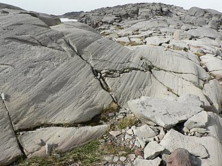
Glacial striations or striae are scratches or gouges cut into bedrock by glacial abrasion. These scratches and gouges were first recognized as the result of a moving glacier in the late 18th century when Swiss alpinists first associated them with moving glaciers. They also noted that if they were visible today that the glaciers must also be receding.

In glaciology, a roche moutonnée is a rock formation created by the passing of a glacier. The passage of glacial ice over underlying bedrock often results in asymmetric erosional forms as a result of abrasion on the "stoss" (upstream) side of the rock and plucking on the "lee" (downstream) side. These erosional features are seen on scales of less than a metre to several hundred metres.

Plucking, also referred to as quarrying, is a glacial phenomenon that is responsible for the weathering and erosion of pieces of bedrock, especially large "joint blocks". This occurs in a type of glacier called a "valley glacier". As a glacier moves down a valley, friction causes the basal ice of the glacier to melt and infiltrate joints (cracks) in the bedrock. The freezing and thawing action of the ice enlarges, widens, or causes further cracks in the bedrock as it changes volume across the ice/water phase transition, gradually loosening the rock between the joints. This produces large pieces of rock called joint blocks. Eventually these joint blocks come loose and become trapped in the glacier.

A tunnel valley is a U-shaped valley originally cut under the glacial ice near the margin of continental ice sheets such as that now covering Antarctica and formerly covering portions of all continents during past glacial ages. They can be as long as 100 km (62 mi), 4 km (2.5 mi) wide, and 400 m (1,300 ft) deep.

An ice cave is any type of natural cave that contains significant amounts of perennial (year-round) ice. At least a portion of the cave must have a temperature below 0 °C (32 °F) all year round, and water must have traveled into the cave’s cold zone.

A glacier cave is a cave formed within the ice of a glacier. Glacier caves are often called ice caves, but the latter term is properly used to describe bedrock caves that contain year-round ice.

Abrasion is a process of erosion which occurs when material being transported wears away at a surface over time. It is the process of friction caused by scuffing, scratching, wearing down, marring, and rubbing away of materials. The intensity of abrasion depends on the hardness, concentration, velocity and mass of the moving particles. Abrasion generally occurs four ways. Glaciation slowly grinds rocks picked up by ice against rock surfaces. Solid objects transported in river channels make abrasive surface contact with the bed and walls. Objects transported in waves breaking on coastlines cause abrasion. And, finally, abrasion can be caused by wind transporting sand or small stones against surface rocks.

Overdeepening is a characteristic of basins and valleys eroded by glaciers. An overdeepened valley profile is often eroded to depths which are hundreds of metres below the deepest continuous line along a valley or watercourse. This phenomenon is observed under modern day glaciers, in salt-water fjords and fresh-water lakes remaining after glaciers melt, as well as in tunnel valleys which are partially or totally filled with sediment. When the channel produced by a glacier is filled with debris, the subsurface geomorphic structure is found to be erosionally cut into bedrock and subsequently filled by sediments. These overdeepened cuts into bedrock structures can reach a depth of several hundred metres below the valley floor.
Subglacial streams are conduits of glacial meltwater that flow at the base of glaciers and ice caps. Meltwater from the glacial surface travels downward throughout the glacier, forming an englacial drainage system consisting of a network of passages that eventually reach the bedrock below, where they form subglacial streams. Subglacial streams form a system of tunnels and interlinked cavities and conduits, with water flowing under extreme pressures from the ice above; as a result, flow direction is determined by the pressure gradient from the ice and the topography of the bed rather than gravity. Subglacial streams form a dynamic system that is responsive to changing conditions, and the system can change significantly in response to seasonal variation in meltwater and temperature. Water from subglacial streams is routed towards the glacial terminus, where it exits the glacier. Discharge from subglacial streams can have a significant impact on local, and in some cases global, environmental and geological conditions. Sediments, nutrients, and organic matter contained in the meltwater can all influence downstream and marine conditions. Climate change may have a significant impact on subglacial stream systems, increasing the volume of meltwater entering subglacial drainage systems and influencing their hydrology.

Ice segregation is the geological phenomenon produced by the formation of ice lenses, which induce erosion when moisture, diffused within soil or rock, accumulates in a localized zone. The ice initially accumulates within small collocated pores or pre-existing cracks, and, as long as the conditions remain favorable, continues to collect in the ice layer or ice lens, wedging the soil or rock apart. Ice lenses grow parallel to the surface and several centimeters to several decimeters deep in the soil or rock. Studies between 1990 and present have demonstrated that rock fracture by ice segregation is a more effective weathering process than the freeze-thaw process which older texts proposed.

Glaciofluvial deposits or Glacio-fluvial sediments consist of boulders, gravel, sand, silt and clay from ice sheets or glaciers. They are transported, sorted and deposited by streams of water. The deposits are formed beside, below or downstream from the ice. They include kames, kame terraces and eskers formed in ice contact and outwash fans and outwash plains below the ice margin. Typically the outwash sediment is carried by fast and turbulent fluvio-glacial meltwater streams, but occasionally it is carried by catastrophic outburst floods. Larger elements such as boulders and gravel are deposited nearer to the ice margin, while finer elements are carried farther, sometimes into lakes or the ocean. The sediments are sorted by fluvial processes. They differ from glacial till, which is moved and deposited by the ice of the glacier, and is unsorted.
References
- ↑ Benn, Douglas I.; Evans, David J.A. (1998). Glaciers and Glaciation (First ed.). London: Arnold. pp. 317–323. ISBN 0340584319.
| | This glaciology article is a stub. You can help Wikipedia by expanding it. |