Icefall

Last updated
The 730 m (2,400 ft) icefall (center) in the Roosevelt Glacier, Mount Baker, Washington, U.S. Roosevelt Glacier 6940.JPG
The 730 m (2,400 ft) icefall (center) in the Roosevelt Glacier, Mount Baker, Washington, U.S.

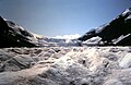
An icefall is a portion of certain glaciers characterized by relatively rapid flow and chaotic crevassed surface, caused in part by gravity. The term icefall is formed by analogy with the word waterfall, which is a similar phenomenon of the liquid phase but at a more spectacular speed. When ice movement of a glacier is faster than elsewhere, because the glacier bed steepens or narrows, and the flow cannot be accommodated by plastic deformation, the ice fractures, forming crevasses. Where two fractures meet, seracs (or ice towers) can be formed. When the movement of the ice slows down, the crevasses can coalesce, resulting in the surface of the glacier becoming smoother. [1]

Contents

Ice flow

Perhaps the most conspicuous consequence of glacier flow, icefalls occur where the glacier bed steepens and/or narrows. Most glacier ice flows at speeds of a few hundred metres per year or less. However, the flow of ice in an icefall may be measured in kilometres per year. Such rapid flow cannot be accommodated by plastic deformation of the ice. Instead, the ice fractures, forming crevasses. Intersecting fractures form ice columns or seracs. These processes are imperceptible for the most part; however, a serac may collapse or topple abruptly and without warning. This behavior often poses the biggest risk to mountaineers climbing in an icefall.

As the glacier transitions below the icefall, the topography of the glacier bed plays a crucial role in modifying its dynamics, leading to a flatter and/or wider bed that significantly reduces the velocity of ice movement. This change in speed and pressure causes crevasses to close up, resulting in a smoother glacier surface that presents fewer challenges for navigation and traversal.

Examples

Icefalls vary greatly in height. The Roosevelt Glacier icefall, on the north face of Mount Baker (Cascade Range, U.S.), is about 730 metres (2,400 feet) high. The ice cliff of the left side of the ice fall and above the debris covering the glacier is 20 to 40 metres (66 to 131 ft) high. Typical of mountain glaciers, this icefall forms as the ice flows from a high elevation plateau or basin accumulation zone to a lower valley ablation zone. Much larger icefalls may be found in the outlet glaciers of continental ice sheets. The icefall feeding the Lambert Glacier in Antarctica is 7 kilometres (4.3 miles) wide and 14 kilometres (8.7 miles) long, even though the elevation difference is only 400 metres (1,300 feet), a little more than half that of the Roosevelt Glacier icefall.

Icefalls are climbed because of their beauty and the challenge they pose. In some cases, an icefall may provide the only feasible or the easiest route up one face of a mountain. An example is the Khumbu Icefall on the Nepalese side of Mount Everest, variously described as "treacherous" and "dangerous." It is about 5,500 metres (18,000 feet) above sea level.

See also

Related Research Articles

<span class="mw-page-title-main">Glacier</span> Persistent body of ice that is moving under its own weight

A glacier is a persistent body of dense ice that is constantly moving under its own weight. A glacier forms where the accumulation of snow exceeds its ablation over many years, often centuries. It acquires distinguishing features, such as crevasses and seracs, as it slowly flows and deforms under stresses induced by its weight. As it moves, it abrades rock and debris from its substrate to create landforms such as cirques, moraines, or fjords. Although a glacier may flow into a body of water, it forms only on land and is distinct from the much thinner sea ice and lake ice that form on the surface of bodies of water.

<span class="mw-page-title-main">Sherpa people</span> Tibetan ethnic group

The Sherpas are one of the Tibetan ethnic groups native to the most mountainous regions of Nepal and Tibetan Autonomous Region. The term sherpa or sherwa derives from the Tibetan-language words ཤར shar ('east') and པ pa ('people'), which refer to their geographical origin in eastern Tibet.

<span class="mw-page-title-main">Mer de Glace</span> Glacier located on the Mont Blanc massif, in the French Alps

The Mer de Glace is a valley glacier located on the northern slopes of the Mont Blanc massif, in the French Alps. It is 7.5 km long and 200 metres (660 ft) deep but, when all its tributary glaciers are taken into account, it can be regarded as the longest and largest glacier in France, and the second longest in the Alps after the Aletsch Glacier.

I can no otherwise convey to you an image of this body of ice, broken into irregular ridges and deep chasms than by comparing it to waves instantaneously frozen in the midst of a violent storm.

<span class="mw-page-title-main">Crevasse</span> A deep crack, or fracture, in an ice sheet or glacier

A crevasse is a deep crack that forms in a glacier or ice sheet. Crevasses form as a result of the movement and resulting stress associated with the shear stress generated when two semi-rigid pieces above a plastic substrate have different rates of movement. The resulting intensity of the shear stress causes a breakage along the faces.

<span class="mw-page-title-main">Glacial motion</span> Geological phenomenon

Glacial motion is the motion of glaciers, which can be likened to rivers of ice. It has played an important role in sculpting many landscapes. Most lakes in the world occupy basins scoured out by glaciers. Glacial motion can be fast or slow, but is typically around 25 centimetres per day (9.8 in/d).

<span class="mw-page-title-main">Khumbu Icefall</span> Glacier in Nepal

The Khumbu Icefall is located at the head of the Khumbu Glacier and the foot of the Western Cwm, which lies at an elevation of 5,486 metres (17,999 ft) on the Nepali slopes of Mount Everest, not far above Base Camp and southwest of the summit. The icefall is considered one of the most dangerous stages of the South Col route to Everest's summit.

<span class="mw-page-title-main">Serac</span> Large block or column of glacial ice

A serac is a block or column of glacial ice, often formed by intersecting crevasses on a glacier. Commonly house-sized or larger, they are dangerous to mountaineers, since they may topple with little warning. Even when stabilized by persistent cold weather, they can be an impediment to glacier travel.

<span class="mw-page-title-main">Bergschrund</span> Crevasse between moving glacier ice and the stagnant ice or firn above

A bergschrund is a crevasse that forms where moving glacier ice separates from the stagnant ice or firn above. It is often a serious obstacle for mountaineers, who sometimes abbreviate "bergschrund" to "schrund". Bergschrunds extend to the bedrock and can have a depth of well over 100 metres (330 ft).

<span class="mw-page-title-main">Ice stream</span> A region of fast-moving ice within an ice sheet

An ice stream is a region of fast-moving ice within an ice sheet. It is a type of glacier, a body of ice that moves under its own weight. They can move upwards of 1,000 metres (3,300 ft) a year, and can be up to 50 kilometres (31 mi) in width, and hundreds of kilometers in length. They tend to be about 2 km (1.2 mi) deep at the thickest, and constitute the majority of the ice that leaves the sheet. In Antarctica, the ice streams account for approximately 90% of the sheet's mass loss per year, and approximately 50% of the mass loss in Greenland.

<i>The Man Who Skied Down Everest</i> 1975 film

The Man Who Skied Down Everest is a Canadian documentary about Yuichiro Miura, a Japanese alpinist who skied down Mount Everest in 1970. The film was produced by Crawley Films' "Budge" Crawley and directed by Crawley and Bruce Nyznik.

<span class="mw-page-title-main">Everest base camps</span> Staging areas for mountaineering activities on Mount Everest

There are two base camps on Mount Everest, on opposite sides of the mountains: South Base Camp is in Nepal at an altitude of 5,364 metres (17,598 ft), while North Base Camp is in China at 5,150 metres (16,900 ft).

<span class="mw-page-title-main">Erebus Glacier Tongue</span>

The Erebus Glacier Tongue is a mountain outlet glacier and the seaward extension of Erebus Glacier from Ross Island. It projects 11 kilometres (6.8 mi) into McMurdo Sound from the Ross Island coastline near Cape Evans, Antarctica. The glacier tongue varies in thickness from 50 metres (160 ft) at the snout to 300 metres (980 ft) at the point where it is grounded on the shoreline. Explorers from Robert F. Scott's Discovery Expedition (1901–1904) named and charted the glacier tongue.

<span class="mw-page-title-main">Blue Glacier</span>

Blue Glacier is a large glacier located to the north of Mount Olympus in the Olympic Mountains of Washington. The glacier covers an area of 1.7 sq mi (4.4 km2) and contains 580,000,000 cu ft (16,000,000 m3) of ice and snow in spite of its low terminus elevation. The glacier length has decreased from about 3.4 mi (5.5 km) in 1800 to 2.7 mi (4.3 km) in the year 2000. Just in the period from 1995 and 2006, Blue Glacier retreated 325 ft (99 m). Blue Glacier is also thinning as it retreats and between 1987 and 2009 the glacier lost 178 ft (54 m) of its depth near its terminus and between 32 and 48 ft in the uppermost sections of the glacier known as the accumulation zone.

<span class="mw-page-title-main">Supraglacial lake</span> Pond of liquid water on the top of a glacier

A supraglacial lake is any pond of liquid water on the top of a glacier. Although these pools are ephemeral, they may reach kilometers in diameter and be several meters deep. They may last for months or even decades at a time, but can empty in the course of hours.

<span class="mw-page-title-main">Ice-sheet dynamics</span> Technical explanation of ice motion within large bodies of ice

Ice sheet dynamics describe the motion within large bodies of ice such as those currently on Greenland and Antarctica. Ice motion is dominated by the movement of glaciers, whose gravity-driven activity is controlled by two main variable factors: the temperature and the strength of their bases. A number of processes alter these two factors, resulting in cyclic surges of activity interspersed with longer periods of inactivity, on both hourly and centennial time scales. Ice-sheet dynamics are of interest in modelling future sea level rise.

<span class="mw-page-title-main">Overdeepening</span> Characteristic of basins and valleys eroded by glaciers

Overdeepening is a characteristic of basins and valleys eroded by glaciers. An overdeepened valley profile is often eroded to depths which are hundreds of metres below the lowest continuous surface line along a valley or watercourse. This phenomenon is observed under modern day glaciers, in salt-water fjords and fresh-water lakes remaining after glaciers melt, as well as in tunnel valleys which are partially or totally filled with sediment. When the channel produced by a glacier is filled with debris, the subsurface geomorphic structure is found to be erosionally cut into bedrock and subsequently filled by sediments. These overdeepened cuts into bedrock structures can reach a depth of several hundred metres below the valley floor.

<span class="mw-page-title-main">2014 Mount Everest ice avalanche</span> Avalanche on Mount Everest

On 18 April 2014, seracs on the western spur of Mount Everest failed, resulting in an ice avalanche that killed sixteen climbing Sherpas in the Khumbu Icefall. This was the same icefall where the 1970 Mount Everest disaster had taken place. Thirteen bodies were recovered within two days, while the remaining three were never recovered due to the great danger in attempting such an expedition. Many Sherpas were angered by what they saw as the Nepalese government's meager offer of compensation to victims' families, and threatened a protest or strike. On 22 April, the Sherpas announced they would not work on Everest for the remainder of 2014 as a mark of respect for the victims.

<span class="mw-page-title-main">Lingtren</span> Himalayan mountain

Lingtren, 6,749 metres (22,142 ft), is a mountain in the Mahalangur Himal area of Himalaya, about 8 kilometres (5.0 mi) distant in a direct line from Mount Everest. It lies on the international border between Nepal and the Tibet Autonomous Region of China and it was first climbed in 1935. A mountain nearby to the west was originally named Lingtrennup but is now more commonly called Xi Lingchain.

The 1951 British Mount Everest reconnaissance expedition ran between 27 August 1951 and 21 November 1951 with Eric Shipton as leader.

<span class="mw-page-title-main">Fissure</span> Long, narrow crack opening on a planetary surface

A fissure is a long, narrow crack opening along the surface of Earth. The term is derived from the Latin word fissura, which means 'cleft' or 'crack'. Fissures emerge in Earth's crust, on ice sheets and glaciers, and on volcanoes.

References

  1. Post, Austin; Edward R. LaChapelle (May 2000) [1971]. Glacier Ice (Revised ed.). Seattle, Washington: University of Washington Press. pp. 18–21. ISBN   0-295-97910-0.