
Auki is the provincial capital of Malaita Province, Solomon Islands. It is situated on the northern end of Langa Langa Lagoon on the north-west coast of Malaita. It is one of the largest provincial towns in Solomon Islands. It was established as the administrative center for Malaita Province in 1909.

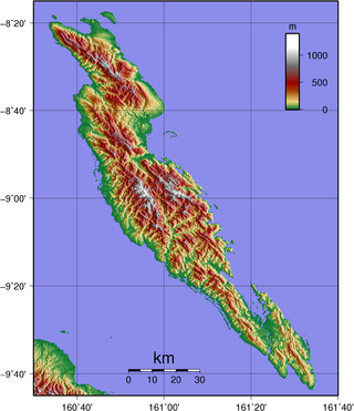
Malaita Province is the most populous and one of the largest of the nine provinces of Solomon Islands. The population of the province is 122,620 (1999). The area of the province is 4,225 km2 (1,631 sq mi).

The Solomon Islands Football Federation is a member of the Oceania Football Confederation. The Solomon Islands national football team made history when they made it to the final Oceania stages of the 2006 World Cup Qualification against Australia. Before the tournament began it was almost presumed this place would go to New Zealand.

South Malaita Island is the island at the southern tip of the larger island of Malaita in the eastern part of Solomon Islands. It is also known as Small Malaita and Maramasike for Areare speakers and Malamweimwei for more than 80% of the islanders. The island is referred to as Iola Raha. It is called "small" to distinguish it from the much larger sibling. It is part of Malaita Province. South Malaita came under effective control of the colonial administration after the Solomon Islands was declared a British Protectorate in 1893. During the colonial days, the island was divided by the colonial government and missionary establishments into the Asimeuri, Asimae, and Raroisu'u districts.

Santa Isabel is the largest island in Isabel Province, Solomon Islands. It is also the longest island, with the third largest surface area, in the country.
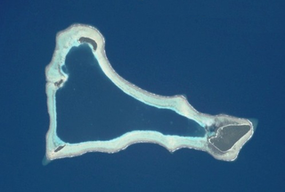
Sikaiana is a small atoll 212 kilometres NE of Malaita in Solomon Islands in the south Pacific Ocean. It is almost 14 kilometres in length and its lagoon, known as Te Moana, is totally enclosed by the coral reef. Its total land surface is only 2 square kilometres. There is no safe anchorage close to this atoll, which makes it often inaccessible to outsiders.
Funaafou or Funa'afou is an artificial island built on the reef in the Lau Lagoon off the northeast coast of Malaita Island. Administratively, it is in the Malaita Province of Solomon Islands. Funa'afou island, which is near the edge of the Makwanu Passage, has about 200 inhabitants. It is the first artificial Island built in the Lau lagoon. According to history, the people of Baleo tribe are the first descendants of Funafou Islands

Laulasi island is an artificial island in the Langa Langa Lagoon, South of Auki on the island of Malaita in Solomon Islands. It is believed that hostilities among the inlanders of Malaita forced some people into the lagoon where over time they built their islands on sandbars after diving for coral. The religion of the island was based on prayers and offerings to the ghosts of dead ancestors, mediated by priests who kept their skulls and relics in tabu houses. Some ancestors were incarnated as sharks which protected their descendants. Langalanga is also the main source of the shell money now made in Solomon Islands.

Langa Langa Lagoon or Akwalaafu is a natural lagoon on the West coast of Malaita near the provincial capital Auki within Solomon Islands. The lagoon is 21 km in length and just under 1 km wide. The "lagoon people" or "salt water people" live on small artificial islands built up on sand bars over time where they were forced to flee from the headhunters of mainland Malaita.
Adagege, alternatively spelled Ada Gege or Ada-gege, is an artificial island built on the reef in the Lau Lagoon on Malaita in Solomon Islands; it is located in Malaita Province. The road from Auki ends at Fouia wharf opposite the islands of Sulufou and Adaege in the Lau Lagoon.
Anuta Paina is an island in Malaita Province, Solomon Islands. It is located off the east coast of Malaita Island.
Maana'omba is an island in Malaita Province, in Solomon Islands.
Mbasakana is an island in Malaita Province, Solomon Islands.

Ndai, formerly known as Gower Island, is an island in Malaita Province, Solomon Islands. It is located to the north of Malaita Island.
Sulufou is an artificial island built on the reef in the Lau Lagoon on Malaita, Malaita Province in the nation of Solomon Islands. The road from Auki ends at Fouia wharf opposite the islands of Sulufou and Adaege in the Lau Lagoon.
The Diocese of Malaita is one of the nine current dioceses of the Anglican Church of Melanesia. One of the four original ACOM dioceses, Malaita diocese was erected in January 1975; it is currently subdivided into six regions of 46 parishes.
The Solomon Cup is the top knockout tournament of the Telekom S-League, an association football cup competition in the Solomon Islands. It is played by senior male football clubs from the top division.
Malu'u is a village on the north coast of Malaita island in the Solomon Islands. The seat of the sub provincial area, it lies on Suafa Bay, within Malaita Province, along the road between Auki and Lau Lagoon.
The 2020–21 Telekom S-League was the 17th season of the Telekom S-League, the top football league in the Solomon Islands.

The Coral reefs of the Solomon Islands consists of six major islands and over 986 smaller islands, in Oceania, to the east of Papua New Guinea and northwest of Vanuatu. The Solomon Islands lie between latitudes 5° and 13°S, and longitudes 155° and 169°E. The distance between the westernmost and easternmost islands is about 1,500 km (930 mi). The Santa Cruz Islands are situated north of Vanuatu and are especially isolated at more than 200 km (120 mi) from the other islands. The Solomon Islands has the 22nd largest Exclusive Economic Zone of 1,589,477 km2 (613,701 sq mi) of the Pacific Ocean.
