Related Research Articles

Solomon Islands is an island country in the South Pacific Ocean, that lies east of Papua New Guinea.
The Shortland Islands is an archipelago of Western Province, Solomon Islands, at 6.92°S 155.88°E. The island group lies in the extreme north-west of the country's territory, close to the south-east edge of Bougainville Island, Papua New Guinea.
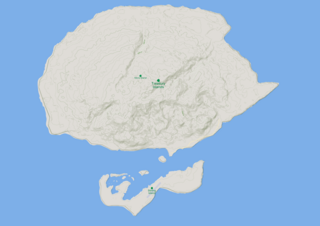
Treasury Islands are a small group of islands a few kilometres to the south of Bougainville and 24 kilometres from the Shortland Islands. They form part of the Western Province of the country of Solomon Islands. The two largest islands in the Treasuries are Mono Island and the smaller Stirling Island. The deep water strait between these two islands is called Blanche Harbour.

The North Solomon Islands form a geographical area covering the more northerly group of islands in the Solomon Islands archipelago and includes Bougainville and Buka Islands, Choiseul, Santa Isabel, the Shortland Islands and Ontong Java Atoll. In 1885 Germany declared a protectorate over these islands forming the German Solomon Islands Protectorate. With the exception of Bougainville and Buka, these were transferred to the British Solomon Islands Protectorate in 1900. Bougainville and Buka continued under German administration until the outset of World War I, when they were transferred to Australia, and after the war, were formally passed to Australian jurisdiction under a League of Nations mandate.
Kennedy Island, is a 1.17 hectares, uninhabited island in Solomon Islands that was named after John F. Kennedy, following an incident involving Kennedy during his World War II naval career. Kennedy Island lies 15 minutes by boat from Gizo, the provincial capital of the Western Province of Solomon Islands.

Kinugasa (衣笠) was the second vessel in the two-vessel Aoba class of heavy cruisers in the Imperial Japanese Navy. The ship was named after Mount Kinugasa, located in Yokosuka, Kanagawa, Japan.

Hatsuyuki was the third of twenty-four Fubuki-class destroyers built for the Imperial Japanese Navy following World War I. When introduced into service, these ships were the most powerful destroyers in the world. They served as first-line destroyers through the 1930s, and remained formidable weapons systems well into the Pacific War.
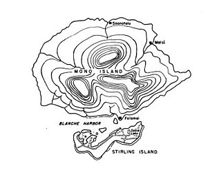
Stirling Island is the smaller island of the Treasury Islands,in the nation state of Solomon Islands.

Fauro Island is an island of the Shortland Islands archipelago, located in the Western Province of Solomon Islands, located at 6°55′S156°4′E. Along the center spine of the island are Mount Pauboleala with an elevation of 574 metres, Mount Lalauka with an elevation of 517 m, and Sharp Peak with an elevation of 484 m.

Shortland Island is the largest island of the Shortland Islands archipelago, in the Western Province of Solomon Islands, at 7°3′S155°45′E.

The Solomon Islands (archipelago) is an island group in the western South Pacific Ocean, north-east of Australia. The archipelago is in the Melanesian subregion and bioregion of Oceania and forms the eastern boundary of the Solomon Sea. The many islands of the archipelago are distributed across Papua New Guinea and Solomon Islands (country). The largest island in the archipelago is Bougainville Island, which is a part of the Autonomous Region of Bougainville along with Buka Island, the Nukumanu Islands, and a number of smaller nearby islands. Much of the remainder falls within the territory of Solomon Islands and include the atolls of Ontong Java, Sikaiana, the raised coral atolls of Bellona and Rennell, and the volcanic islands of Choiseul, Guadalcanal, Makira, Malaita, New Georgia, the Nggelas, Santa Isabel, and the Shortlands. The Santa Cruz Islands are not a part of the archipelago.
Bougainville Strait separates Choiseul Island, part of the Solomon Islands from Bougainville Island, the next to the northward and part of Papua New Guinea. The first European to pass through the strait was Louis Antoine de Bougainville in 1768, whose name was given to this water pathway. Lieutenant John Shortland of the Royal Navy sailed through the strait in 1788, giving the name of Treasury Islands to the numerous islands, lying in the strait. He named the strait after himself, but it later became known as Bougainville.
Faisi is a small island in the Western Province of Solomon Islands. The island is a part of Shortland Islands archipelago.
Balalae Island is an island of the Shortland Islands Group in the Western Province of Solomon Islands.
Pirumeri Island is an island of the Shortland Islands archipelago, in Western Province, in the independent nation of Solomon Islands. The estimated terrain elevation above sea level is some 25 metres.
Magusaiai is an island in the Shortland Islands archipelago, in Western Province, in the independent nation of Solomon Islands. The estimated terrain elevation above sea level is some 14 metres.
Masamasa is an island of the Shortland Islands Archipelago, located in the Western Province of Solomon Islands in the Pacific Ocean. The estimated terrain elevation above sea level is some 97 meters. To the east lies Fauro Island, to the south lies Piedu Island (Piru), and to the east lies the northern tip of Choiseul Island.
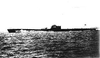
I-16 was one of five Type C cruiser submarines of the C1 sub-class built for the Imperial Japanese Navy, Commissioned in 1940, she deployed a midget submarine for the attack on Pearl Harbor and for an attack on ships at Diego-Suarez in Madagascar, conducted an anti-shipping patrol in the Indian Ocean, and took part in the Guadalcanal campaign, New Guinea campaign, and Bougainville campaign before she was sunk in May 1944.
References
- ↑ "Ovau Island: Solomon Islands". Geographic Names. Retrieved 27 July 2018.
- ↑ "Ovau Island". Geoview. Retrieved 27 July 2018.
- ↑ "Ovau Island". MapCarta. Retrieved 27 July 2018.
- ↑ "Shortland Islands". Solomon Islands Historical Encyclopaedia 1893-1978. Retrieved 4 August 2018.
6°47′S156°0′E / 6.783°S 156.000°E
| | This Solomon Islands location article is a stub. You can help Wikipedia by expanding it. |